
Majorstuen or Majorstua is a particularly affluent neighbourhood in the Frogner borough in the inner part of Oslo, Norway.

Røa is a neighbourhood and a former administrative borough of the city of Oslo, Norway. In 2004 the borough of Røa was merged with neighbouring Vinderen to become Vestre Aker borough.

The Oslo Metro is the rapid transit system of Oslo, Norway, operated by Sporveien T-banen on contract from the transit authority Ruter. The network consists of five lines that all run through the city centre, with a total length of 85 kilometres (53 mi), serving 101 stations of which 17 are underground or indoors. In addition to serving 14 out of the 15 boroughs of Oslo, two lines run to Kolsås and Østerås, in the neighboring municipality of Bærum. In 2016, the system had an annual ridership of 118 million.

Stortinget is an underground rapid transit station on the Common Line of the Oslo Metro, Norway. It is located in the heart of the city center, next to the Parliament of Norway Building (Stortinget). The station is served by all of the five lines of the metro. At the street level, the station serves tram routes 11, 12, 13, 17, 18 and 19. Lines 11, 12 and 13 serves Øvre Slottsgate on the Vika Line while Lines 17, 18 and 19 stops at Tinghuset in the Ullevål Hageby Line. Also close to the station, there is a stop named Prof. Aschehougs gate that stops line FB5 to Oslo Airport, Gardermoen. Stortinget is 'kilometer marker zero' for the metro network and is owned by Sporveien T-banen.

The Røa Line is a rapid transit line of the Oslo Metro, Norway, which runs from Majorstuen in Oslo to Østerås in Bærum. It serves neighborhoods such as Smestad, Hovseter, Huseby and Røa in northwestern Oslo, and Grini, Øvrevoll and Østerås in northeastern Bærum. The line is served by Line 2 of the metro, which connects to the city center via the Common Tunnel and onwards along the Furuset Line. The lowest part of the Røa Line, consisting of two stations, is shared with the Kolsås Line, and thus also served by Line 2 of the metro. The Røa Line is owned by Kollektivtransportproduksjon, and operated by Oslo T-banedrift on contract with the public transport agency Ruter.

The Sognsvann Line is a rapid transit line on the Oslo Metro of Norway. It branches from the Common Tunnel at Majorstuen and runs 6.0 kilometers (3.7 mi) to Sognsvann. After Ullevål stadion, the Ring Line branches off. The Sognsvann Line serves the northwestern and northern neighborhoods of Oslo, mostly within the borough of Nordre Aker. The line is owned and maintained by Kollektivtransportproduksjon and has nine stations. The western end of line 5 serves the entire line. Line 4 and the eastern end of line 5 serve the southern part of the line up to Ullevål stadion before branching off and continuing along the Ring Line. This gives an average five-minute headway on the southern part and an average fifteen-minute headway on the northern part of the line.

Peder Balke was a Norwegian painter. He is known for portraying the landscape of Norway in a romantic and dramatic manner.
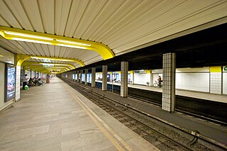
The Common Tunnel, sometimes called the Common Line, is a 7.3-kilometer (4.5 mi) long tunnel of the Oslo Metro which runs through the city center of Oslo, Norway. The name derives from the fact that all five lines of the metro use the tunnel, which runs from Majorstuen to Tøyen. The section has six stations, including the four busiest on the metro.

Valkyrie plass is a square in Oslo, Norway, located one block southeast of Majorstuen.

Valkyrie plass was a metro station and a tram station on the Oslo Metro and the Oslo Tramway.
A/S Kristiania Elektriske Sporvei or KES, nicknamed the Blue Tramway, was a company which operated part of the Oslo Tramway between 1894 and 1924. It built a network of four lines in Western Oslo, the Briskeby Line and the Frogner Line which ran to Majorstuen, and two other consecutive lines, the Skøyen Line and the Lilleaker Line. These all connected to a common line through the city center which terminated at Jernbanetorget.

The Briskeby Line is a line of the Oslo Tramway in Norway. It runs westwards from Jernbanetorget in the city center, passing through the neighborhoods of Briskeby and Uranienborg before reaching its terminus at Majorstuen. The section from Jernbanetorget to Inkognitogata is shared with the Skøyen Line; on this section it connects with the important transport hub Nationatheatret. This part is variously served by route 11, 12 and 13. From the Inkognitogata stop, the line moves through the residential areas around the Royal Palace, in the streets named Riddervolds gate, Briskebyveien, Holtegata and Bogstadveien. The part of the line in Bogstadveien from Majorstuen to Rosenborg is also served by route 19, which operates the Homansbyen Line.

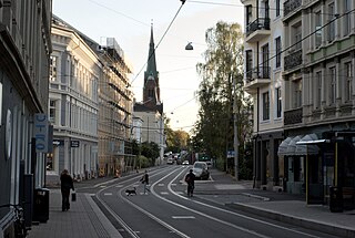
The history of the Oslo Tramway and Oslo Metro in Oslo, Norway, starts in 1875, when Kristiania Sporveisselskab (KSS) opened two horsecar lines through the city centre. In 1894, Kristiania Elektriske Sporvei (KES) built the first electric street tramways, which ran west from the city centre. Within six years, all tramways were electric. The city council established Kristiania Kommunale Sporveie (KKS) in 1899, which built three lines before it was sold to KSS six years later. Both KSS and KES were taken over by the municipality in 1924, becoming Oslo Sporveier. The company gradually expanded the city tram network, which reached its peak length in 1939.

Schultz' gate station was a tram stop on the Oslo Tramway located in the Bogstadveien Street. It was preceded by the Majorstuen stop and succeeded by Rosenborg stop on the Briskeby Line. In 2014, the Rosenborg and Schultz' gate stops were merged with the newly established Bogstadveien, located between those stops.
Rosenborg was a tram stop on the Oslo Tramway. It was located on the shopping street Bogstadveien, in the area of the same name in the neighbourhood Hegdehaugen. The station was preceded by Schultz' gate on the Briskeby Line and succeeded by Homansbyen and Uranienborgveien on the Homansby and Briskeby Line, respectively. In 2005, the station was upgraded, with heightened platforms, new skeds and real-time monitors. In 2014, the stop was closed and replaced by the newly established Bogstadveien stop, located a bit further north on the Bogstadveien street, closer to Majorstuen. The succeeding Uranienborg stop was relocated to the street junction between Bogstadveien and Josefines gate, and renamed Rosenborg.

Hegdehaugen is a neighbourhood in the borough Frogner of Oslo, Norway. It is located in the West End between Homansbyen and Majorstuen. The name origins from the man's name Heide.
Rosenborg, formerly Uranienborgveien is at tram stop on the Briskeby Line of the Oslo Tramway. It is located in Josefines gate, close to its street junction with Bogstadveien. It serves the neighborhoods Rosenborg, Hegdehaugen and Uranienborg in the West End of Oslo. The station is preceded and succeeded by Bogstadveien and Briskeby, respectively. The station used to be near the junction of Holtegata and Uranienborgveien streets, but it was moved towards Hegdehaugen and Rosenborg in 2009, after the line had been upgraded and reconstructed. In 2014, it was moved even further towards Rosenborg, and consequently renamed. In the same move, the former Rosenborg stop was replaced with the newly established Bogstadveien stop, situated further north, closer to Majorstuen.

Bogstadveien is a tram stop on the Homansbyen Line and the Briskeby Line. It is served by lines 11 and 19. The Homansbyen Line served by Line 19 and the Briskeby Line served by line 11, branch off here. The next station westbound is the terminus, Majorstuen. There are two different tram stops eastbound. For passengers on Line 11, the next stop is Rosenborg. For passengers on Line 19, the next stop is Homansbyen.

Disen is a tram stop located on the Oslo Tramway network. Located in Nordre Aker in northern Oslo, the station is part of the Kjelsås Line, that operates between Storo and Kjelsås. Disen also has a balloon loop, for trams to turn around and change direction. However, trams do not regularly terminate at Disen anymore. Disen was opened on the 25th September, 1934. Disen was also closed along with the rest of the Kjelsås Line between 2002 and 2004. Uni-directional SL79 trams serve the tram stop, but occasionally SL95 trams serve Line 12.


