Related Research Articles

East Liberty is an unincorporated community and census-designated place (CDP) located in Perry Township, Logan County, Ohio, United States. As of the 2020 census, it had a population of 371. It is located just off U.S. Route 33, 10 miles (16 km) east of Bellefontaine and 46 miles (74 km) northwest of Columbus. It has a post office with the ZIP code 43319.

Rushcreek Township is one of the seventeen townships of Logan County, Ohio, United States. As of the 2020 census, the population was 2,153.

Ridley Creek is a tributary of the Delaware River in Chester and Delaware counties, Pennsylvania in the United States.

Big Walnut Creek starts near Mount Gilead, Ohio in Morrow County. It flows south to eastern Delaware County and parallels Alum Creek. It passes to the east of Sunbury and into Hoover Reservoir, which then crosses into Franklin County. From the dam outflow in Westerville the creek flows through Gahanna and Whitehall. Near Obetz it is joined by its principal tributaries Alum Creek and Blacklick Creek at the Three Creeks Columbus Metro Park. It flows through southern Franklin County and joins the Scioto River near the Franklin-Pickaway Counties line at 39°47′57″N83°00′34″W.
Turtle Creek is a 13.7-mile-long (22.0 km) tributary of the Little Miami River in Turtlecreek Township, Warren County, Ohio, which takes its name from this creek. Turtle Creek is named for Chief Little Turtle, of the Miami Indian Tribe Turtle Creek is a tributary within the Little Miami and Ohio River watersheds.
Conotton Creek is a tributary of the Tuscarawas River, 38.7 miles (62.3 km) long, in eastern Ohio in the United States. Via the Tuscarawas, Muskingum and Ohio Rivers, it is part of the watershed of the Mississippi River, draining an area of 286 square miles (741 km2) in Carroll, Harrison and Tuscarawas County, Ohio. The source is at 1240 feet and the mouth is at 874 feet. Dover Dam, downstream on the Tuscarawas river, is normally dry, but can impound a reservoir on Conotton and tributaries to a pool elevation of 916 feet for downstream flood control by the Corps of Engineers. From its source in eastern Harrison County, Ohio the creek flows west northwest through Jewitt, Scio, Conotton, Bowerston, Leesville, Sherrodsville, New Cumberland and Somerdale before reaching its mouth in central Tuscarawas County, Ohio. The Wheeling and Lake Erie Railway is situated in the valley. Ohio State Route 151 runs in the valley from near the source to Bowerston. Ohio State Route 212 run along the valley from Bowerston to the mouth. The Conotton Creek Trail runs from Bowerston to Jewett.
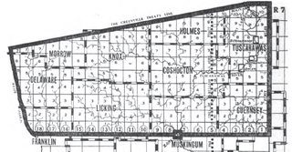
The United States Military District was a land tract in central Ohio that was established by the Congress to compensate veterans of the American Revolutionary War for their service. The tract contains 2,539,110 acres (10,275.4 km2) in Noble, Guernsey, Tuscarawas, Muskingum, Coshocton, Holmes, Licking, Knox, Franklin, Delaware, Morrow, and Marion counties.

The Salt Reservations were a collection of land tracts surrounding salt springs in Ohio and some other states that were donated to the states by the federal government early in the 19th century.

Zane's Tracts were three parcels of land in the Northwest Territory of the United States, later Ohio, that the federal government granted to Ebenezer Zane late in the 18th century, as compensation for establishing a road with ferry service over several rivers.

Wolf Creek is a 19.8-mile-long (31.9 km) tributary of the Great Miami River in southwestern Ohio in the United States. It rises in western Montgomery County, northwest of Brookville, and flows generally southeast, passing through the center of Trotwood and joining the Great Miami in downtown Dayton.
Slate Run is a tributary to the Scioto River; it flows through the Northwest corner of Upper Arlington, Ohio. The creek gets its name from the slate that makes up the creek bed. It winds through a ravine and has several small, yet prominent waterfalls. The creek is mainly fed by storm water runoff which makes the creek very susceptible to running dry during extended periods of no rain.
Todd Fork is a stream in Clinton and Warren counties, Ohio, in the United States. It is a tributary of the Little Miami River.
Swamp Creek is a stream in Preble County, Ohio, in the United States.
Cherokee Run is a stream in the U.S. state of Ohio.
Bokengehalas Creek is a stream in the U.S. state of Ohio. It is a tributary of the Great Miami River.
McKees Creek is a stream in the U.S. state of Ohio. It is a tributary of Stony Creek.
Cherokee Mans Run is a stream located entirely within Logan County, Ohio.
Blue Jacket Creek is a stream located entirely within Logan County, Ohio. The 7.8-mile (12.6 km) long stream is a tributary of Bokengehalas Creek.
Cones Mills is a ghost town in Delaware County, in the U.S. state of Ohio. It was located in Thompson Township.
Edinburgh is a ghost town in Delaware County, in the U.S. state of Ohio. It was located in Scioto Township, but the precise location of the extinct town is unknown to the GNIS.
References
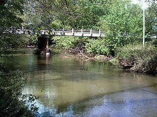
- 1 2 3 U.S. Geological Survey Geographic Names Information System: Bokes Creek
- ↑ Lentz, Ed (2003). Columbus: The Story of a City. The Making of America Series. Arcadia Publishing. p. 33. ISBN 9780738524290. OCLC 52740866.
- ↑ History of Logan County and Ohio: Containing a History of the State of Ohio, from Its Earliest Settlement to the Present Time. O.L. Baskin. 1880. p. 507.
- ↑ History of Delaware County and Ohio. O. L. Baskin & Company. 1880. p. 483.