Bomputu

Last updated
Bomputu
Village
Democratic Republic of the Congo relief location map.jpg
Red pog.svg
Bomputu
Coordinates: 0°28′01″S20°08′31″E / 0.466980°S 20.141985°E / -0.466980; 20.141985 Coordinates: 0°28′01″S20°08′31″E / 0.466980°S 20.141985°E / -0.466980; 20.141985
CountryDemocratic Republic of the Congo
Province Tshuapa
Elevation
331 m (1,086 ft)

Bomputu is a community on the Salonga River in the province of Tshuapa in the Democratic Republic of the Congo. In the colonial period it held a trading post.

Contents

Location

Bomputu is on the east shore of the Salonga River in the province of Tshuapa. [1] It is in the extreme west of Boende Territory. [2] The village is at an elevation of about 331 metres (1,086 ft). [3]

Colonial era

The villages of Bomputu, Boende, Baliko and Iyonje all belonged to one Bolangala clan. Ekof'Olomba was in charge of Bomputu. A local account says how Ekof'Olomba took a shield and spears and went to make a pact of friendship with the Whites. Lemesu, leader of the Whites, told him to get his people out of the forest, where they were hiding. The White then imposed the harvest of rubber on all four villages, and told Ekof'Olomba to bring him supplies each day. [4]

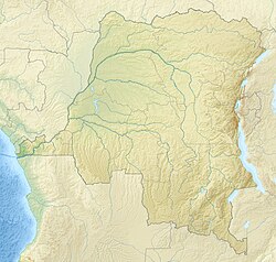
As of 1 January 1894 the Société anonyme belge pour le commerce du Haut-Congo (SAB) had 83 factories and posts, including some in the French territory to the west of the Congo and Ubangi rivers. A map shows the company had posts along the upper Ruki River (i.e. the Busira) at Bilakamba, Bombimba, Bussira Manene, Moniaca, Bocoté and Yolongo. It also had the post at Bomputu on the Lengué (Salonga) River, and posts at Balalondzy, Ivulu and Ivuku on the Momboyo River. [5]

In the late 1920a and early 1930s the local people in Equateur district were passively resisting the colonial occupation. [6] The authorities found the people of the villages of Bolemba, Bombongo, Bomputu, Liemba, Biala and Yundji were aggressively hostile, and implemented a military action in the area. [7]

Notes

    Citatiions

    1. Node: Bomputu (1736044949).
    2. Province de la Tshuapa Territoire de Boende.
    3. Bomputu ... Geonames.
    4. Vinck 1991, p. 546.
    5. Map: Société anonyme belge ...
    6. Veerle Nollet 2003, p. 85.
    7. Veerle Nollet 2003, p. 86.

    Sources

    Related Research Articles

    Équateur (former province) Place in Democratic Republic of the Congo

    Équateur was a province in the northwest of the Belgian Congo and the successor Republic of the Congo, now known as Democratic Republic of the Congo. It had its origins in the Équateur District of the Congo Free State, the private property of King Leopold II of Belgium. It was upgraded to the status of a province in 1917. Between 1933 and 1947 it was named Coquilhatville. In 1962 it was divided into three smaller provinces, but there were recombined in 1966. Équateur was one of the eleven provinces of the Democratic Republic of the Congo until 2015, when it was split into the new, smaller Équateur province, as well as the Tshuapa, Mongala, Nord-Ubangi and Sud-Ubangi provinces.

    Ruki River

    The Ruki is a river in the Democratic Republic of the Congo. It is a left tributary of the Congo River. It may be seen as the lower reach of the Busira River, which in turn may be seen as the lower reach of the Tshuapa River.

    Busira River

    The Busira River is a river in the Democratic Republic of the Congo. It is the main tributary of the Ruki River, which in turn is a tributary of the Congo River. The Busira may be seen as the upper reach of the Ruki River. It is navigable year round.

    Tshuapa District District in Équateur, Democratic Republic of the Congo

    Tshuapa District, was a district of the Belgian Congo and the Democratic Republic of the Congo created in 1933 in the Coquilhatville Province. At its greatest extent it roughly corresponded to the present provinces of Équateur and Tshuapa.

    Sankuru District District in Kasaï-Oriental, Democratic Republic of the Congo

    Sankuru District was a district of the Belgian Congo and Democratic Republic of the Congo. It went through various changes in extent, but roughly corresponded to the modern Sankuru Province.

    Marcel Maquet

    Marcel Maquet was a Belgian colonial administrator who became commissioner of Stanleyville Province in 1940, then governor of Léopoldville Province in 1943.

    Charles-Marie-Nestor Duchesne was a Belgian lawyer and colonial administrator who was governor of Équateur Province in the Belgian Congo from 1921 to 1933.

    Georges Van der Kerken

    Georges Van der Kerken was a Belgian lawyer, colonial administrator and professor. He served as acting governor of Équateur Province in the Belgian Congo in 1922. He is known for his publications on the ethnology of peoples of the Belgian Congo.

    Lac Léopold II District District in Équateur, Belgian Congo

    Lac Léopold II District was a district of the Congo Free State, Belgian Congo and Democratic Republic of the Congo. It went through various changes in extent, but roughly corresponded to the modern Mai-Ndombe Province.

    Stanleyville District District in Orientale, Democratic Republic of the Congo

    Stanleyville District was a district of the Belgian Congo and Democratic Republic of the Congo. It went through various changes in extent. Between 1933 and 1963 it had roughly the same extent as the current Tshopo province.

    Gada River (Uele)

    The Gada River is a left tributary of the Uele River, which it joins downstream from Niangara in the Haut-Uélé province of the Democratic Republic of the Congo.

    Ernest Baert

    Ernest Baert was a Belgian soldier, explorer and colonial administrator who was active in the Congo Free State.

    The Société anonyme belge pour le commerce du Haut-Congo (SAB) was a private enterprise in the Congo Free State, later the Belgian Congo, that operated a string of trading stations in the Congo River basin, and exported ivory, rubber and other local products. The ruthless treatment of the local people by SAB agents inspired Joseph Conrad to write his 1899 novel Heart of Darkness.

    Lomela River

    The Lomela River is a river in the Democratic Republic of the Congo. It is one of the main tributaries of the Busira River, which forms where the Lomela meets the Tshuapa River. The Busira is in turn the main tributary of the Ruki River, which enters the Congo River to the north of Mbandaka.

    Busira (Democratic Republic of the Congo) Village in Province of Équateur, Democratic Republic of the Congo

    Busira, or Busira Manene, is a village in the Province of Équateur in the Democratic Republic of the Congo, in Busira Territory.

    Bokote Village in Équateur, Democratic Republic of the Congo

    Bokote is a community on the Busira River in the Province of Équateur in the Democratic Republic of the Congo. In the colonial period it held a trading post and a Catholic mission.

    Lotoko, Democratic Republic of the Congo Village in Sankuru, Democratic Republic of the Congo

    Lotoko is a community on the Busira River in the Province of Équateur in the Democratic Republic of the Congo. In the colonial period it held a trading post.

    Monieka Village in Équateur, Democratic Republic of the Congo

    Monieka is a community on the Busira River in the Province of Équateur in the Democratic Republic of the Congo. In the colonial period it held a trading post and a Protestant mission.

    Bus Bloc

    The Bus Bloc, or Bloc de la Busira-Momboyo, was a huge concession in the Congo Free State, later the Belgian Congo, operated by the Société anonyme belge pour le commerce du Haut-Congo (SAB). It covered land along and between the Busira River and Momboyo River. In the early days the SAB exploited the local people ruthlessly in their demands for rubber, and many died.