Warren County is a county located on the Cumberland Plateau in Middle Tennessee, one of the three Grand Divisions of the U.S. state of Tennessee. As of the 2020 census, the population was 40,953. Its county seat is McMinnville. Warren County comprises the McMinnville, TN Micropolitan Statistical Area.

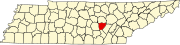
Van Buren County is a county located in the U.S. state of Tennessee. As of the 2020 census, the population was 6,168, making it the second-least populous county in Tennessee. Its county seat is Spencer.

Grayling Charter Township is a charter township of Crawford County in the U.S. state of Michigan. The population was 5,827 as of the 2010 census, down from 6,516 at the 2000 census. The city of Grayling is surrounded by Grayling Charter Township, but both are administered autonomously.

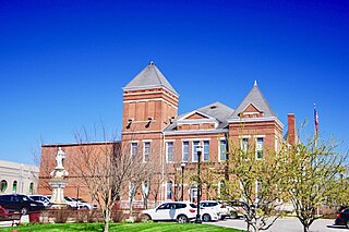
Spencer is a town in Van Buren County, Tennessee, United States. The population was 1,683 as of the 2010 census. It is the county seat of Van Buren County. It is home to Fall Creek Falls State Park.

McClurg is an unincorporated community in extreme northeastern Taney County, Missouri, United States. It is located on Missouri Supplemental Route W, approximately three miles east of Brownbranch or twenty miles (32 km) northeast of Forsyth. McClurg is part of the Branson, Missouri Micropolitan Statistical Area.
Pittsburg is an unincorporated community in Van Buren County, Iowa, United States. It is located at 40.75639ºN and 91.99167ºW.
St. Albans is an unincorporated community in northeastern Franklin County, Missouri, United States. It lies approximately five miles northeast of Labadie and about seven miles west of Wildwood. St. Albans is above the Missouri River floodplain. The town borders a small section of St. Charles County which, unlike the rest of the county, lies on the south side of the Missouri River.
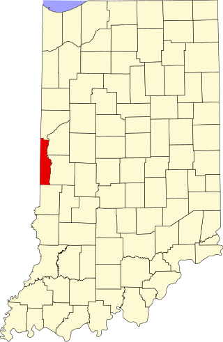
Randall is a former town in Helt Township, Vermillion County, in the U.S. state of Indiana. Randall is also 1.6 miles northwest of another extinct town: Toronto, on W County Road 700 S. The nearest extant community is the town of Dana, to the northeast.
Foxboro is an unincorporated community, in Douglas County, in the town of Summit, in the northwestern part of the U.S. state of Wisconsin.

Lees Station is an unincorporated community in Bledsoe County, Tennessee. It lies along U.S. Route 127 southwest of the city of Pikeville, the county seat of Bledsoe County. Its elevation is 853 feet (260 m), and it is at 35°33′27″N85°15′3″W. The various forms of its names led the Board on Geographic Names officially to designate it Lees in 1916. In 1969, the official name was changed to Lees Station.
ʻŌʻōkala is an unincorporated community on the island of Hawaiʻi in Hawaiʻi County, Hawaii, United States. It lies along Hawaii Route 19 north of Hilo, the county seat of Hawaiʻi County. Its elevation is 371 feet (113 m), and it is located at 20°1′3″N155°17′14″W. Because the community has borne multiple names, the Board on Geographic Names officially designated it "ʻŌʻōkala" in 2000. It has a post office with the ZIP code 96774.
Selma is an unincorporated community in northwestern Van Buren County, Iowa, United States. It lies along Iowa Highway 16 northwest of the city of Keosauqua, the county seat of Van Buren County. Its elevation is 617 feet (188 m).

Buffalo is an unincorporated community and census-designated place (CDP) in southern LaRue County, Kentucky, United States. Its population was 498 as of the 2010 census. It lies along Kentucky Route 61 south of the city of Hodgenville, the county seat of LaRue County. Its elevation is 748 feet (228 m), and it is located at 37°30′43″N85°41′55″W. Although Buffalo is unincorporated, it has a post office, with the ZIP code of 42716.

Big Plain is an unincorporated community in Fairfield Township, Madison County, Ohio, United States. It is located at 39°50′19″N83°17′21″W, at the intersection of West Jefferson-Kiousville Road and Big Plain-Circleville Road, approximately four miles north of Kiousville.
Manara is an unincorporated community in Marion Township, Fayette County, Ohio, United States. It is located at 39°36′09″N83°18′47″W, at the intersection of Washington-Waterloo Road and Bloomingburg-New Holland Road.
Unitia is an Unincorporated community of Loudon County, Tennessee. Historically it was a crossroads village, the site of a post office, and a stop on the Underground Railroad. The historical center of the community was flooded in the 1940s by the filling of the reservoir behind Fort Loudoun Dam.
Nashville is an unincorporated community in Jackson County, in the U.S. state of Iowa.
Springboro is an unincorporated community in Prairie Township, White County, in the U.S. state of Indiana.
Vernon is an unincorporated community in Van Buren County, in the U.S. state of Iowa.
Utica is an unincorporated community in Van Buren County, in the U.S. state of Iowa. The community is at the junction of County Road W-30 and Iowa Highway 16.