
Lake Mead is a reservoir formed by Hoover Dam on the Colorado River in the Southwestern United States. It is located in the states of Nevada and Arizona, 24 mi (39 km) east of Las Vegas. It is the largest reservoir in the US in terms of water capacity. Lake Mead provides water to the states of Arizona, California, and Nevada as well as some of Mexico, providing sustenance to nearly 20 million people and large areas of farmland.
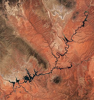
Lake Powell is an artificial reservoir on the Colorado River in Utah and Arizona, United States. It is a major vacation destination visited by approximately two million people every year. It is the second largest artificial reservoir by maximum water capacity in the United States behind Lake Mead, storing 24,322,000 acre-feet (3.0001×10¹⁰ m3) of water when full. However, Lake Mead has fallen below Lake Powell in size several times during the 21st century in terms of volume of water, depth and surface area.

Horsetooth Reservoir is a large reservoir in southern Larimer County, Colorado, in the foothills just west of the city of Fort Collins, Colorado. The reservoir runs north-south for approximately 6.5 miles (10 km) and is approximately one-half mile (1 km) wide. Its shape and orientation are the result of the fact that the main body of the reservoir is contained between several homoclinal ridges. A ridge composed of Dakota sandstone runs along the east side where gaps in the ridge are plugged by dams. On the west (uphill) side there are two prominent ridges topped by erosion-resistant sandstones of the Lyons and Ingleside formations. Gaps in these ridges have created a handful of bays and coves the largest of which is Inlet Bay, home to a marina and campgrounds.

Bonny Lake State Park is a former state park located in Yuma County, Colorado near Hale. Created in 1966 and closed in 2011, Bonny Lake was the easternmost state park in Colorado.
The Central Utah Project is a US federal water project that was authorized for construction under the Colorado River Storage Project Act of April 11, 1956, as a participating project. In general, the Central Utah Project develops a portion of Utah's share of the yield of the Colorado River, as set out in the Colorado River Compact of 1922.
Lake Pueblo State Park is a state park located in Pueblo County, Colorado. It includes 60 miles (97 km) of shoreline and 10,000 acres (40 km2) of land. Activities it offers include two full-service marinas, recreational fishing, hiking, camping and swimming at a special swim beach.

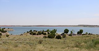
Keith Sebelius Lake, formerly known as Norton Reservoir, is a man-made reservoir on Prairie Dog Creek in northwest Kansas. Built and managed by the U.S. Bureau of Reclamation, it is used for flood control, irrigation, recreation, and local water supply. Prairie Dog State Park is located on its shore.

Waconda Lake, also known as Glen Elder Reservoir, is a reservoir in Mitchell County and Osborne County, Kansas, United States. Built and managed by the U.S. Bureau of Reclamation for flood control and irrigation, it is also used for recreation. Glen Elder State Park is located on its north shore.

Lovewell Reservoir is a reservoir in Jewell County, Kansas, United States. Built and managed by the U.S. Bureau of Reclamation, it is used for flood control, irrigation, and recreation. Lovewell State Park is located on its north shore.

Cedar Bluff Reservoir is a reservoir in Trego County, Kansas, United States. Built and managed by the U.S. Bureau of Reclamation for irrigation and area water supply, it is also used for flood control and recreation. Cedar Bluff State Park is located on its shore.

Webster Reservoir is a reservoir in Rooks County, Kansas, United States. Built and managed by the U.S. Bureau of Reclamation, it is used for flood control, irrigation, and recreation. Webster State Park is located on its shore.
Virginia Smith Dam is a dam in Garfield County, Nebraska, about five miles northwest of Burwell.

Carter Lake Dam is a dam in Larimer County, Colorado.
Twin Lakes Dam is a dam in Lake County, Colorado, about 13 miles (21 km) south of Leadville.

Angostura Dam is an embankment dam across the Cheyenne River in Fall River County in southwestern South Dakota in the United States, about 75 miles (121 km) south of Rapid City. The dam consists of an earth-fill embankment with a concrete spillway section, 193 feet (59 m) high and 2,030 feet (620 m) long; it withholds the 195,121-acre-foot (0.240678 km3) Angostura Reservoir. The dam was conceived as early as 1913, but it was not until the 1930s when a regional drought caused crop failures that the project received widespread support from farmers. Built from 1946 to 1949, the dam is part of the Angostura Division of the Pick-Sloan Missouri Basin Program, and is operated by the U.S. Bureau of Reclamation.

Cherry Creek Dam is a dam in Arapahoe County, Colorado southeast of Denver.
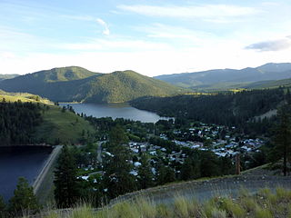
Salmon Lake Dam is a dam in Okanogan County, Washington.
The Marble Canyon Dam, also known as the Redwall Dam, was a proposed dam on the Colorado River in Arizona. The dam was intended to impound a relatively small reservoir in the central portion of Marble Canyon to develop hydroelectric power. Plans centered on two sites between miles 30 and 40 in the canyon. At one point a 38-mile (61 km) tunnel was proposed to a site just outside Grand Canyon National Park to develop the site's full power generation potential, reducing the Colorado River to a trickle through the park.

