| Borów | |
|---|---|
| Village | |
 Borów | |
| Coordinates: 52°5′N19°35′E / 52.083°N 19.583°E | |
| Country | |
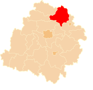
| Voivodeship | Łódź |
| County | Łowicz |
| Gmina | Bielawy |
| Population (approx.) | 350 |
Borów [ˈbɔruf] is a village in the administrative district of Gmina Bielawy, within Łowicz County, Łódź Voivodeship, in central Poland. [1] It lies approximately 5 kilometres (3 mi) west of Bielawy, 25 km (16 mi) west of Łowicz, and 35 km (22 mi) north of the regional capital Łódź.

A village is a clustered human settlement or community, larger than a hamlet but smaller than a town, with a population ranging from a few hundred to a few thousand. Though villages are often located in rural areas, the term urban village is also applied to certain urban neighborhoods. Villages are normally permanent, with fixed dwellings; however, transient villages can occur. Further, the dwellings of a village are fairly close to one another, not scattered broadly over the landscape, as a dispersed settlement.
Gmina Bielawy is a rural gmina in Łowicz County, Łódź Voivodeship, in central Poland. Its seat is the village of Bielawy, which lies approximately 20 kilometres (12 mi) west of Łowicz and 34 km (21 mi) north of the regional capital Łódź.
Łowicz County is a unit of territorial administration and local government (powiat) in Łódź Voivodeship, central Poland. It came into being on January 1, 1999, as a result of the Polish local government reforms passed in 1998. Its administrative seat and only town is Łowicz, which lies 48 kilometres (30 mi) north-east of the regional capital Łódź.
The village has an approximate population of 350.
The manor of the Grabski family, where the politicians of the Second Polish Republic Władysław Grabski, Stanisław Grabski and Zofia Kirkor-Kiedroniowa were born, is located there.

The Second Polish Republic, commonly known as interwar Poland, refers to the country of Poland in the period between the First and Second World Wars (1918–1939). Officially known as the Republic of Poland, sometimes Commonwealth of Poland, the Polish state was re-established in 1918, in the aftermath of World War I. When, after several regional conflicts, the borders of the state were fixed in 1922, Poland's neighbours were Czechoslovakia, Germany, the Free City of Danzig, Lithuania, Latvia, Romania and the Soviet Union. It had access to the Baltic Sea via a short strip of coastline either side of the city of Gdynia. Between March and August 1939, Poland also shared a border with the then-Hungarian governorate of Subcarpathia. The Second Republic ceased to exist in 1939, when Poland was invaded by Nazi Germany, the Soviet Union and the Slovak Republic, marking the beginning of the European theatre of World War II.
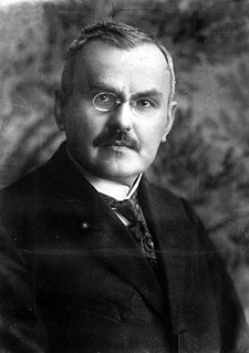
Władysław Dominik Grabski was a Polish National Democratic politician, economist and historian. He was the main author of the currency reform in the Second Polish Republic and served as Prime Minister of Poland in 1920 and from 1923–1925. He was the brother of Stanisław Grabski and Zofia Kirkor-Kiedroniowa.

Stanisław Grabski was a Polish economist and politician, member of the Sejm, associated with the National Democracy political camp. Stanisław was the brother of another prominent Polish politician, economist and Prime Minister Władysław Grabski, and political activist Zofia Kirkor-Kiedroniowa.


