
The Brahmaputra is a trans-boundary river which flows through Tibet, Northeastern India, and Bangladesh. It is also known as the Yarlung Tsangpo in Tibetan, the Siang/Dihang River in Arunachali, Luit and Brahmaputra in Assamese, Brahmaputro in Bengali in India and Jamuna River in Bangla in Bangladesh. It is the 9th largest river in the world by discharge, and the 15th longest.
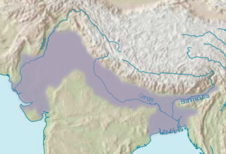
The Indo-Gangetic Plain, also known as the North Indian River Plain, is a 700-thousand km2 (172-million-acre) fertile plain encompassing northern regions of the Indian subcontinent, including most of northern and eastern India, most of eastern-Pakistan, virtually all of Bangladesh and southern plains of Nepal. The region is named after the Indus and the Ganges rivers and encompasses a number of large urban areas. The plain is bound on the north by the Himalayas, which feed its numerous rivers and are the source of the fertile alluvium deposited across the region by the two river systems. The southern edge of the plain is marked by the Deccan Plateau. On the west rises the Iranian Plateau. Many developed cities like Delhi, Dhaka, Kolkata, Lahore and Karachi are located in the Indo-Gangetic Plain.

The Ganges Basin is a part of the Ganges-Brahmaputra-Meghna (GBM) basin draining 1,999,000 square kilometres in Tibet, Nepal, India and Bangladesh. To the north, the Himalaya or lower parallel ranges beyond form the Ganges-Brahmaputra divide. On the west the Ganges Basin borders the Indus basin and then the Aravalli ridge. Southern limits are the Vindhyas and Chota Nagpur Plateau. On the east the Ganges merges with the Brahmaputra through a complex system of common distributaries into the Bay of Bengal. Its catchment lies in the states of Uttar Pradesh (294,364 km2), Madhya Pradesh (198,962 km2), Bihar (143,961 km2), Rajasthan (112,490 km2), West Bengal (71,485 km2), Haryana (34,341 km2), Himachal Pradesh (4,317 km2), Delhi, Arunachal Pradesh (1,484 km2), the whole of Bangladesh, Nepal and Bhutan. Several tributaries rise inside Tibet before flowing south through Nepal. The basin has a population of more than 500 million, making it the most populated river basin in the world.

Dihing or Burhi Dihing is a large tributary, about 380 kilometres (240 mi) long, of the Brahmaputra River in Upper Assam in northeastern India. The river originates at 2,375 metres (7,792 ft) above sea level in the Eastern Himalayas in Arunachal Pradesh and flows through Tinsukia (Tinicukeeya) and Dibrugarh Districts in Assam to its confluence with the Brahmaputra at Dihingmukh. Its watershed covers about 6,000 square kilometres (2,300 sq mi). The Dihing has created number of oxbow lakes in the area.
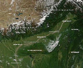
This article discusses the geological origin, geomorphic characteristics, and climate of the northeastern Indian state of Assam. Extending from 89° 42′ E to 96° E longitude and 24° 8′ N to 28° 2′ N latitude, it has an area of 78,438 km2, similar to that of Ireland or Austria.
The Bhogdoi River is a tributary of the Brahmaputra in India. From its origin in the Naga hills it flows through the city of Jorhat and then it merges with another river and its name becomes Gelabill. The previous name of the river was Desoi. The Bhoghdoi river has become heavily polluted over the years.

The Subansiri River is a trans-Himalayan river and a tributary of the Brahmaputra River that flows through Tibet's Lhuntse County in the Shannan Prefecture, and the Indian states of Arunachal Pradesh and Assam. The Subansiri is 442 kilometres (275 mi) long, with a drainage basin 32,640 square kilometres (12,600 sq mi). It is the largest tributary of the Brahmaputra contributing 7.92% of the Brahmaputra's total flow.

Dibang River, also known as Sikang by the Adi and Talo in Idu, is an upstream tributary river of the Brahmaputra in the Indian state of Arunachal Pradesh. It originates and flows through the Mishmi Hills in the (Upper) Dibang Valley and Lower Dibang Valley districts.
The Brahmaputra floods refers to a catastrophic flood event that occurred in 2012 along the Brahmaputra River and its tributaries, as well as in subsequent years.

The Pagladiya River is a northern bank tributary of the Brahmaputra River in the Indian state of Assam. The Pagladiya river originates in the Bhutan hills and flows through Baksa District and Nalbari district before its confluence with the Brahmaputra river. Pagladiya River is perennial, very shallow, and is characteristically known for flash floods and high discharge rates.
The Gabharu River is a northern bank tributary of the Brahmaputra River in the Indian state of Assam. The Gabharu river originates in the Kalafangapo hills of Arunachal Pradesh in the West Kameng District and flows through Sonitpur district of Assam before its confluence with the Brahmaputra river at Gadharu Mukh of Sonitpur district. The Gabharu river consists of two right bank subtributaries known as Sonairupai river and Gelgeli river and Mora Depota river is the left bank sub tributary.
The Kulsi River is a tributary of the Brahmaputra River in the Indian state of Assam. The river originates from West Khasi Hills of Meghalaya. The Kulsi river is known as Khir River in its origin. After travelling 12 km in Meghalaya, this river then flows through Kamrup district of Assam and is known as Kulsi. The confluence of the Kulsi river with Brahmaputra River is at Nagarbera of Kamrup district, Assam.

The Champabati River is a tributary of the Brahmaputra River in the Indian state of Assam. The Champabati River has three sub tributaries - Bhur River, Lopani and Dhol pani which are originated from Bhutan hills.
The Jiadhal River is a northern sub-tributary of the Brahmaputra River in the Indian state of Assam. The river originates from the hills of Arunachal Pradesh. The Jiadhali river flows through the Dhemaji district and takes the name of Kumotiya River from Gogamukh.The river finally joins Subansiri river, a major tributary of Brahmaputra River. Jiadhal River is known as ‘Sorrow of Dhemaji’ for the heavy damage caused by annual flood and erosion.

The Dikrong River is a sub-tributary of the Brahmaputra River in the Indian state of Assam. The Dikrong river originates in the hills of Arunachal Pradesh and flows through major cities like Nirjuli in Arunachal Pradesh and Bihpuria in Assam before its confluence with the Subansiri River.
The Bharalu River is a tributary of the Brahmaputra River in the Indian state of Assam. The Bharalu river originates in the Khasi Hills of Meghalaya and flows through the heart of Guwahati before its confluence with the Brahmaputra river. Bharalu river is one of the most polluted rivers in the state of Assam.

The Dudhnoi River is a sub-tributary of the Brahmaputra River in the Indian state of Assam. The Dudhnoi river originates in the East Garo Hills of Meghalaya. The Dudhnoi River meets Krishnai River at Matia of Goalpara district and then flows as Mornoi River before its confluence with the Brahmaputra river. Floods in Goalpara district is dictated by the Dudhnoi river.
The Krishnai River is a sub-tributary of the Brahmaputra River in the Indian state of Assam. The Krishnai river originates in the West Garo Hills of Meghalaya. The Krishnai River meets Dudhnoi River at Matia of Goalpara district and then flows as Mornoi River before its confluence with the Brahmaputra river.

The Tipkai River is a north and Himalayan tributary of the Brahmaputra River in the Indian state of Assam. It rises in the Bhutan hills, flows through the Kokrajhar district and Dhubri district of Assam and joins the Brahmaputra River at Chatakurachar of Dhubri district.

