This article needs additional citations for verification .(February 2022) |
In Canada, a borough is a municipal subdivision of, and formerly a suburb politically associated with (but not part of), a city.
This article needs additional citations for verification .(February 2022) |
In Canada, a borough is a municipal subdivision of, and formerly a suburb politically associated with (but not part of), a city.
In what is today Toronto, the former Metropolitan Toronto, an upper-tier regional municipality-type of municipal government, had five boroughs; East York, Etobicoke, North York, Scarborough, and York, surrounding a then-much-smaller City of Toronto, which was not a borough. In the late 1970s and early 1980s, the boroughs were promoted to city status, with the exception of East York. At the time, East York was the only municipality in Canada designated as a borough. When the municipalities of Metro Toronto were amalgamated in 1998 to create the present city, East York lost this status. [1] Today, there are no longer any boroughs in Ontario.
In Quebec, the term borough is used as the formal translation into English of the French arrondissement , an administrative subdivision of a major city. There are many boroughs in Quebec. Most of the communities in Quebec now designated as boroughs were villes (cities or towns) prior to 2002.

A borough is an administrative division in various English-speaking countries. In principle, the term borough designates a self-governing walled town, although in practice, official use of the term varies widely.

A municipality is usually a single administrative division having corporate status and powers of self-government or jurisdiction as granted by national and regional laws to which it is subordinate.

The Golden Horseshoe is a secondary region of Southern Ontario, Canada, which lies at the western end of Lake Ontario, with outer boundaries stretching south to Lake Erie and north to Lake Scugog, Lake Simcoe and Georgian Bay of Lake Huron. The region is the most densely populated and industrialized in Canada. Based on the 2021 census, with a population of 7,759,635 people in its core and 9,765,188 in its greater area, the Golden Horseshoe accounts for over 20 percent of the population of Canada and more than 54 percent of Ontario's population. It is part of the Quebec City–Windsor Corridor, itself part of the Great Lakes megalopolis.

King is a township in York Region north of Toronto, within the Greater Toronto Area in Ontario, Canada.

Temiskaming Shores is a city in the Timiskaming District in Northeastern Ontario, Canada. It was created by the amalgamation of the town of New Liskeard, the town of Haileybury, and the township of Dymond in 2004. The city had a total population of 9,634 in the Canada 2021 Census. Temiskaming Shores is Ontario's second-smallest city, in terms of population, after Dryden. Haileybury is the seat of Timiskaming District.
The Municipality of Metropolitan Toronto was an upper-tier level of municipal government in Ontario, Canada, from 1953 to 1998. It was made up of the old city of Toronto and numerous townships, towns and villages that surrounded Toronto, which were starting to urbanize rapidly after World War II. It was commonly referred to as "Metro Toronto" or "Metro".
The term township, in Canada, is generally the district or area associated with a town. The specific use of the term to describe political subdivisions has varied by country, usually to describe a local rural or semirural government within the country itself.
A regional municipality is a type of Canadian municipal government similar to and at the same municipal government level as a county, although the specific structure and servicing responsibilities may vary from place to place. Regional municipalities were formed in highly populated areas where it was considered more efficient to provide certain services, such as water, emergency services, and waste management over an area encompassing more than one local municipality. For this reason, regions may be involved in providing services to residents and businesses.
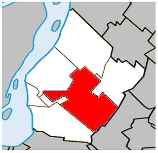
Saint-Hubert is a borough in the city of Longueuil, located in the Montérégie region of Quebec, Canada. It had been a separate city prior to January 1, 2002, when it along with several other neighbouring south shore municipalities were merged into Longueuil. Saint-Hubert had a population of 78,336 in 2006. The area of the borough is 65.98 km2 (25.48 sq mi). Longueuil's city hall is now located in Saint-Hubert. Saint-Hubert is located about 14 kilometres (8.7 mi) from downtown Montreal.

The census geographic units of Canada are the census subdivisions defined and used by Canada's federal government statistics bureau Statistics Canada to conduct the country's quinquennial census. These areas exist solely for the purposes of statistical analysis and presentation; they have no government of their own. They exist on four levels: the top-level (first-level) divisions are Canada's provinces and territories; these are divided into second-level census divisions, which in turn are divided into third-level census subdivisions and fourth-level dissemination areas.

York County is a historic county in Upper Canada, Canada West, and the Canadian province of Ontario. It was organized by the Upper Canada administration from the lands of the Toronto Purchase and others.

Montreal East is an on-island suburb in southwestern Quebec, Canada, on the island of Montreal. Montreal-Est has been home to many large oil refineries since 1915.

Napanee station in Napanee, Ontario, Canada is served by Via Rail trains running from Toronto to Ottawa. The 1856 limestone railway station was an unstaffed but heated shelter with telephones and washrooms, which would open at least half an hour before a train arrives. The platform is wheelchair-accessible. As of February 2023, the shelter was locked.
Local government in Canada can be defined as all elected local authorities which are legally empowered to make decisions on behalf of its electors, excluding the federal government, provincial and territorial governments, and First Nations, Métis and Inuit governments. This can include municipalities, school boards, health authorities, and so on.

The amalgamation of Toronto was the creation of the city limits of Toronto, Ontario, Canada after amalgamating, annexing, and merging with surrounding municipalities since the 18th century. The most recent occurrence of amalgamation was in 1998, which dissolved the federation of Metropolitan Toronto and its constituent municipalities, and created the current "megacity" of Toronto.
A merger, consolidation or amalgamation, in a political or administrative sense, is the combination of two or more political or administrative entities, such as municipalities, counties, districts, etc., into a single entity. This term is used when the process occurs within a sovereign entity.
| | This Canadian location article is a stub. You can help Wikipedia by expanding it. |