
The Lake District, also known as the Lakes or Lakeland, is a mountainous region and national park in Cumbria, North West England. It is famous for its landscape, including its lakes, coast, and the Cumbrian mountains; and for its literary associations with Beatrix Potter, John Ruskin, and the Lake Poets.

Westmorland is a historic county in Northern England.

Kirkby Lonsdale is a town and civil parish in the Westmorland and Furness district of Cumbria, England, on the River Lune. Historically in Westmorland, it lies 13 miles (21 km) south-east of Kendal on the A65. The parish recorded a population of 1,771 in the 2001 census, increasing to 1,843 at the 2011 Census.

Eden was a local government district in Cumbria, England, based at Penrith Town Hall in Penrith. It was named after the River Eden, which flows north through the district toward Carlisle. Its population of 49,777 at the 2001 census, increased to 52,564 at the 2011 Census. A 2019 estimate was 53,253. In July 2021 it was announced that, in April 2023, Cumbria would be divided into two unitary authorities. On 1 April 2023, Eden District Council was abolished and its functions transferred to the new authority Westmorland and Furness, which also covers the former districts of Barrow-in-Furness and South Lakeland.

Wast Water or Wastwater is a lake located in Wasdale, a valley in the western part of the Lake District National Park, England. The lake is almost three miles long and more than one-third mile (500 m) wide. It is a glacial lake, formed in a glacially 'over-deepened' valley. It is the deepest lake in England at 258 feet (79 m). The surface of the lake is about 200 feet (60 m) above sea level, while its bottom is over 50 feet (15 m) below sea level. It is owned by the National Trust.
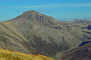
Great Gable is a mountain in the Lake District, United Kingdom. It is named after its appearance as a pyramid from Wasdale, though it is dome-shaped from most other directions. It is one of the most popular of the Lakeland fells, and there are many different routes to the summit. Great Gable is linked by the high pass of Windy Gap to its smaller sister hill, Green Gable, and by the lower pass of Beck Head to its western neighbour, Kirk Fell.

The River Kent is a short river in the county of Cumbria in England. It originates in hills surrounding Kentmere, and flows for around 20 miles (32 km) into the north of Morecambe Bay. The upper reaches and the western bank of the estuary are located within the boundaries of the Lake District National Park. The river flows in a generally north to south direction, passing through Kentmere, Staveley, Burneside, Kendal and Sedgwick. Near Sedgwick, the river passes through a rock gorge which produces a number of low waterfalls. This section is popular with kayakers as it offers high quality whitewater for several days after rain. The village of Arnside is situated on the east bank of the Kent estuary, just above Morecambe Bay, and a tidal bore known as the Arnside Bore forms in the estuary at this point on high spring tides.

Dale Head is a fell in the north-western sector of the Lake District, in northern England. It is 753 metres or 2,470 foot above sea level and stands immediately north of Honister Pass, the road between Borrowdale and Buttermere.

Grayrigg Forest is a hill in Cumbria, England, located on the eastern edge of what might be considered the Lake District. In August 2016 it became part of the eponymous national park. Reaching 494 metres (1,621 ft) above sea level, its summit is attainable from the less well-known Borrowdale valley.
Orton is a village and civil parish in Cumbria, England. It lies 15 miles (24 km) south of Penrith, 8 miles (13 km) from Appleby-in-Westmorland and 1.5 miles (2.4 km) from the M6 motorway. The village is in the upper Lune Valley, at the foot of Orton Scar in the Orton Fells. The Lake District is nearby. The parish includes a wide area outside the village, and had a population of 594 in 2001, decreasing to 588 at the 2011 Census.

Tebay Services are motorway service stations on the M6 motorway in the Westmorland and Furness district of Cumbria, England. The northbound opened in 1972 and the southbound in 1993. They are known for their family-run business which eschews the typical facilities at British motorway services for a farm shop and buildings in keeping with the local environment.

Coniston is a village and civil parish in the Westmorland and Furness district of Cumbria, England. In the 2001 census the parish had a population of 1,058, decreasing at the 2011 census to 928. Within the boundaries of the historic county of Lancashire, it is in the southern part of the Lake District National Park, between Coniston Water, the third longest lake in the Lake District, and Coniston Old Man.

Borrowdale is a valley in the English Lake District. It is located in the county of Westmorland, and is sometimes referred to as Westmorland Borrowdale in order to distinguish it from a more famous Borrowdale located in Cumberland.

Walla Crag is a fell in the English Lake District, near Keswick. The fell is a short walk from Keswick and overlooks Derwentwater.

Seat Sandal is a fell in the English Lake District, situated four kilometres north of the village of Grasmere from where it is very well seen. Nevertheless, it tends to be overshadowed by its more illustrious neighbours in the Eastern Fells, Helvellyn and Fairfield.

Stainton Beck is a watercourse in Cumbria, England. Its upper reaches are known as St. Sunday's Beck.
Birk Beck is a minor river in Cumbria.

Keisley is a small hamlet in the English county of Cumbria. It is located in the Dufton civil parish and the Eden district.

Whinfell Beacon is a hill of 472 metres (1,549 ft) in South Lakeland, Cumbria, England, to the east of the Lake District. It is in the far east of the Lake District National Park since the national park's expansion in 2019. It is east of the A6 road and west of the M6 motorway, south of Borrowdale, Westmorland and east of the upper reaches of the River Mint.
Stock Ghyll, also known as Stock Gill, Stock Gill Beck and Stock Beck, is a stream in South Lakeland, in the ceremonial county of Cumbria and the historic county of Westmorland. It flows about four miles from Red Screes through the town of Ambleside to the River Rothay. Its course includes two long-popular tourist attractions, Stockghyll Force and Bridge House. Stock Ghyll has been painted by J. M. W. Turner, John Ruskin, Kurt Schwitters, and many others. Its name derives from Old English stocc, 'tree-trunk', and Old Norse gil, 'a deep glen'.
