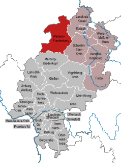
Mengeringhausen is a village and a municipal district of Bad Arolsen in Waldeck-Frankenberg, in Hesse, Germany. Its population is estimated at 3,800. First time mentioned as a town 'Stadt Mengeringhausen' in 1234. The town was in possession of sovereign principality Waldeck. Between 1689–1728 town was a headquarters of chancellors of Waldeck state.
Dreiskopf is a mountain of Landkreis Waldeck-Frankenberg, Hesse, Germany.
The Eisenberg is a hill in the county of Landkreis Waldeck-Frankenberg, Hesse, Germany.
Ettelsberg is a mountain of Landkreis Waldeck-Frankenberg, Hesse, Germany.
Hegekopf is a mountain of Landkreis Waldeck-Frankenberg, Hesse, Germany.
Hohe Warte is a mountain of Landkreis Waldeck-Frankenberg, Hesse, Germany.
Hopperkopf is a mountain of Landkreis Waldeck-Frankenberg, Hesse, Germany.
Iberg is a mountain of Landkreis Waldeck-Frankenberg, Hesse, Germany.
Hohes Lohr is a mountain of Landkreis Waldeck-Frankenberg, Hesse, Germany.
Mittelsberg is a mountain of Landkreis Waldeck-Frankenberg, Hesse, Germany.
Mühlenkopf is a mountain of Landkreis Waldeck-Frankenberg, Hesse, Germany.
Orenberg is a mountain of Landkreis Waldeck-Frankenberg, Hesse, Germany.
Peterskopf is a mountain of Landkreis Waldeck-Frankenberg, Hesse, Germany.
Hohe Pön is a mountain of Landkreis Waldeck-Frankenberg, Hesse, Germany.
Sengelsberg is a mountain of Landkreis Waldeck-Frankenberg, Hesse, Germany.
Traddelkopf is a mountain of Landkreis Waldeck-Frankenberg, Hesse, Germany.
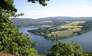
The Edersee is an 11.8 km² reservoir in Waldeck-Frankenberg, Hesse, Germany with 199.3 million m³ of storage space. It has the 2nd largest area, and the 3rd largest volume, of all reservoirs in Germany. It is located on the Fulda Tributary of Eder behind the 48m high Edersee Dam.

The Edertalschule is a traditional Gymnasium in Frankenberg (Eder). It is located in the southwestern part of the district Waldeck-Frankenberg in Hesse, and is the only Gymnasium in the old district of Frankenberg. Despite the more rural location, it is one of the largest Gymnasium in Hesse.