Burgwald

Last updated

Burgwald
Evangelische Kirche Burgwald Ernsthausen.jpg
Protestant Church
Wappen Burgwald.svg
Location of Burgwald within Waldeck-Frankenberg district
Burgwald in KB.svgBattenbergRosenthalFrankenbergLichtenfelsDiemelseeWaldeck
Germany adm location map.svg
Red pog.svg
Burgwald
Hesse location map.svg
Red pog.svg
Burgwald
Coordinates: 51°00′N08°45′E / 51.000°N 8.750°E / 51.000; 8.750
Country Germany
State Hesse
Admin. region Kassel
District Waldeck-Frankenberg
Subdivisions5 Ortsteile
Government
   Mayor (202026) Lothar Koch [1] (Ind.)
Area
  Total41.29 km2 (15.94 sq mi)
Highest elevation
400 m (1,300 ft)
Lowest elevation
250 m (820 ft)
Population
 (2022-12-31) [2]
  Total5,034
  Density120/km2 (320/sq mi)
Time zone UTC+01:00 (CET)
  Summer (DST) UTC+02:00 (CEST)
Postal codes
35099
Dialling codes 06451 / 06457
Vehicle registration KB
Website www.burgwald.de

Burgwald is a municipality in Waldeck-Frankenberg in Hesse, Germany.

Contents

Geography

Location

Burgwald lies east of Battenberg and roughly 30 km north of the university town of Marburg. The community lies on the northwestern edge of the Burgwald range, Hesse's biggest contiguous woodland.

Neighbouring communities

Burgwald borders in the north on the town of Frankenberg, in the east on the community of Haina, in the south on the town of Rosenthal (all in Waldeck-Frankenberg), in the southwest on the community of Münchhausen (Marburg-Biedenkopf), and in the west on the town of Battenberg and the community of Allendorf (both in Waldeck-Frankenberg).

Constituent communities

The community is divided into Birkenbringhausen in the northwest, Bottendorf somewhat more towards the northeast, Burgwald and Wiesenfeld towards the centre, and Ernsthausen to the south.

History

Burgwald is quite a new name for the main community. Until 1996, it was known as Industriehof.

Amalgamations

As part of Hesse's municipal reforms on 1 July 1971, the communities of Birkenbringhausen, Ernsthausen and Wiesenfeld merged to form the greater community. On 1 January 1974, Bottendorf was amalgamated with Burgwald as well.

Politics

Municipal council

The council's 27 seats are apportioned thus, in accordance with municipal elections held on 26 March 2006 (each party's share of the vote is also shown, and figures in parentheses are for the 2001 election):

Note: The last three are citizens' coalitions.

Coat of arms

Burgwald's civic coat of arms has some unusual divisions. The crenellated wall and the line of fir trees are, as the German blazon describes them, not charges, but rather divisions of the shield, although most observers would see a castle wall and a line of trees (things, rather than dividing lines). According to the blazon, the only charge is the cross of the Order of St. John in the shield's lowest division.

The shield's colours are blue, green and silver – blue for the sky, silver for a castle's battlements and the cross, and green for the treetops. The battlements refer to the Kesterburg (now called the Christenberg), a castle in the Burgwald range. The cross refers to local history, namely Wiesenfeld's. In 1238, this village was founded as a prospective Order of St. John centre.

Partnerships

Economy and infrastructure

Transport

Through the community runs Federal Highway (Bundesstraße) B 252 connecting Marburg and Korbach.

Birkenbringhausen, Wiesenfeld and Ernsthausen are stops on the Burgwaldbahn railway line from Frankenberg to Marburg. The stations in Burgwald are in the tariff zone of the North Hesse Transport Association (Nordhessischer Verkehrsverbund; NVV).

Several signposted bicycle paths cross the municipal area or lead right to it. West past Birkenbringhausen run the Hessian cycle path R8 and the Ederauenweg ("Eder floodplain way"), which runs alongside the Eder from its source in the Rothaargebirge to its mouth where it empties into the Fulda. East of Bottendorf, the Hessian cycle path R6 runs through the Burgwald range. The Lahn-Eder cycle path, running from Marburg to Frankenberg reaches the former district seat of Frankenberg from Ernsthausen in the south by way of the Bottendorf area.

Literature

Established businesses

Related Research Articles

Waldeck-Frankenberg is a Kreis (district) in the north of Hesse, Germany. Neighbouring districts are Höxter, Kassel, Schwalm-Eder, Marburg-Biedenkopf, Siegen-Wittgenstein, Hochsauerland.

<span class="mw-page-title-main">Wetter, Hesse</span> Town in Hesse, Germany

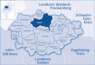
Wetter (Hessen) is a small town in Hesse, Germany. The rather unusual designation Wetter (Hessen-Nassau) stems from a time when the town belonged to the Prussian province of the same name, and nowadays is only used by the railway – even today, the railway station in town bears this name.

<span class="mw-page-title-main">Rauschenberg, Hesse</span> Town in Hesse, Germany

Rauschenberg is a town in the north of Marburg-Biedenkopf district in Hesse, Germany.

<span class="mw-page-title-main">Waldeck, Hesse</span> Town in Hesse, Germany

Waldeck is a small town in Waldeck-Frankenberg district in northwestern Hesse, Germany. Its located near the Edersee, which is a popular destination for tourists and locals alike.

<span class="mw-page-title-main">Battenberg (Eder)</span> Town in Hesse, Germany

Battenberg (Eder) is a small town in Waldeck-Frankenberg district, the state of Hesse, Germany. The town is noted for giving its name to the Battenberg family, a morganatic branch of the ruling House of Hesse-Darmstadt, and through it, the name Mountbatten used by members of the British royal family, a literal translation of Battenberg.

<span class="mw-page-title-main">Hatzfeld</span> Town in Hesse, Germany

Hatzfeld (Eder) is a small town in Waldeck-Frankenberg district in Hesse, Germany.

<span class="mw-page-title-main">Twistetal</span> Municipality in Hesse, Germany

Twistetal is a municipality in Waldeck-Frankenberg in northwest Hesse, Germany, southwest of Bad Arolsen.

<span class="mw-page-title-main">Angelburg</span> Municipality in Hesse, Germany

Angelburg is a municipality in western Marburg-Biedenkopf in northwest Middle Hesse in Germany.

<span class="mw-page-title-main">Wohratal</span> Municipality in Hesse, Germany

Wohratal is a municipality in Marburg-Biedenkopf district in Hessen, Germany.

<span class="mw-page-title-main">Bad Zwesten</span> Municipality in Hesse, Germany

Bad Zwesten is a municipality in the Schwalm-Eder district of Hesse, Germany.

<span class="mw-page-title-main">Frankenberg, Hesse</span> Town in Hesse, Germany

Frankenberg an der Eder is a town in Waldeck-Frankenberg district, Hesse, Germany.

<span class="mw-page-title-main">Neuental</span> Municipality in Hesse, Germany

Neuental is a municipality in the Schwalm-Eder district in Hesse, Germany.

<span class="mw-page-title-main">Frankenau</span> Town in Hesse, Germany

Frankenau is a small town in Waldeck-Frankenberg district in Hesse, Germany.

<span class="mw-page-title-main">Gemünden (Wohra)</span> Town in Hesse, Germany

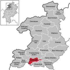
Gemünden is a town in Waldeck-Frankenberg district in Hesse, Germany.

<span class="mw-page-title-main">Rosenthal, Hesse</span> Town in Hesse, Germany

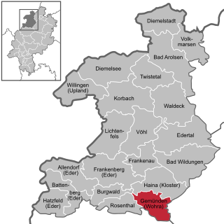
Rosenthal is a small town in southeast Waldeck-Frankenberg district in Hesse, Germany.

<span class="mw-page-title-main">Allendorf (Eder)</span> Municipality in Hesse, Germany

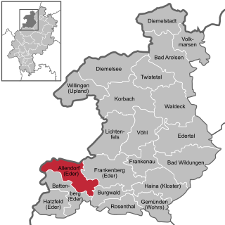
Allendorf (Eder) (German:[ˈaləndɔʁf] ) is a municipality which situated in the north west of Hesse, Germany. The municipality is within the Waldeck-Frankenberg district in a rural region called the upper Eder Valley. The Burgwald range is located west of Allendorf while the Breite Struth hills are in Allendorf's east.

<span class="mw-page-title-main">Edertal</span> Municipality in Hesse, Germany

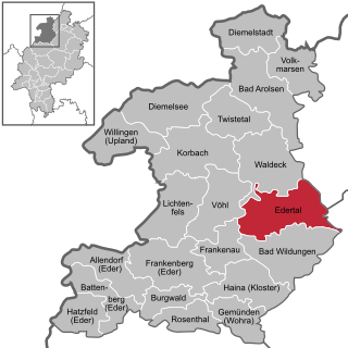
Edertal is a municipality in Waldeck-Frankenberg in northern Hesse, Germany.

<span class="mw-page-title-main">Haina</span> Municipality in Hesse, Germany

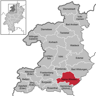
Haina (Kloster) is a municipality in Waldeck-Frankenberg in northwest Hesse, Germany.

<span class="mw-page-title-main">Warburg–Sarnau railway</span>

The Warburg–Sarnau railway is a 100.9 kilometre-long, single-track, partially disused secondary railway line in North Rhine-Westphalia and North Hesse. The middle section, Korbach–Frankenberg, is called the Untere Edertalbahn or the Nationalparkbahn and the southern section, Frankenberg–Sarnau(–Marburg), is called the Burgwaldbahn.

References

  1. "Ergebnisse der letzten Direktwahl aller hessischen Landkreise und Gemeinden" (XLS) (in German). Hessisches Statistisches Landesamt. 5 September 2022.
  2. "Bevölkerung in Hessen am 31.12.2022 nach Gemeinden" (XLS) (in German). Hessisches Statistisches Landesamt. June 2023.