Marburg-Biedenkopf is a Kreis (district) in the west of Hesse, Germany. Neighboring districts are Waldeck-Frankenberg, Schwalm-Eder, Vogelsbergkreis, Gießen, Lahn-Dill, Siegen-Wittgenstein.
Schwalm-Eder-Kreis is a Kreis (district) in the north of Hesse, Germany. Neighbouring districts are Kassel, Werra-Meißner, Hersfeld-Rotenburg, Vogelsberg, Marburg-Biedenkopf, and Waldeck-Frankenberg.
Waldeck-Frankenberg is a Kreis (district) in the north of Hesse, Germany. Neighbouring districts are Höxter, Kassel, Schwalm-Eder, Marburg-Biedenkopf, Siegen-Wittgenstein, Hochsauerland.
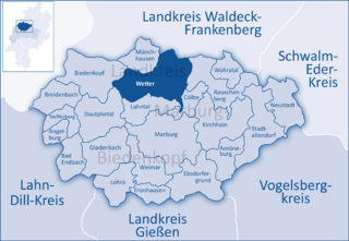
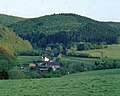
Wetter (Hessen) is a small town in Hesse, Germany. The rather unusual designation Wetter (Hessen-Nassau) stems from a time when the town belonged to the Prussian province of the same name, and nowadays is only used by the railway – even today, the railway station in town bears this name.

Rauschenberg is a town in the north of Marburg-Biedenkopf district in Hesse, Germany.

Waldeck is a small town in Waldeck-Frankenberg district in northwestern Hesse, Germany. Its located near the Edersee, which is a popular destination for tourists and locals alike.

Battenberg is a small town in the district of Waldeck-Frankenberg in the state of Hesse, Germany. It is located on the river Eder, a tributary of the Fulda, which flows into the Weser, and lies at the southeastern edges of the Rothaar Mountains. The closest larger cities are Marburg, Siegen, and Kassel, and the town is approximately equally far away from Frankfurt am Main, Cologne, and Dortmund.

Biedenkopf is a spa town in western Hesse, Germany with a population of 13,491 (2020).
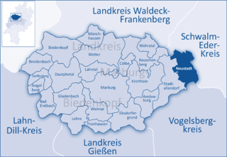
Neustadt is a town in the Marburg-Biedenkopf district in Hesse, Germany.

Cölbe is a municipality in Marburg-Biedenkopf district in Hesse, Germany.

Wohratal is a municipality in Marburg-Biedenkopf district in Hessen, Germany.
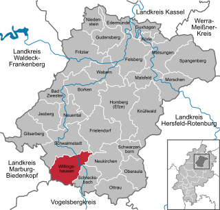
Willingshausen is a municipality in the Schwalm-Eder district in Hesse, Germany.

Frankenau is a small town in Waldeck-Frankenberg district in Hesse, Germany.
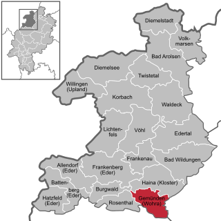
Gemünden is a town in Waldeck-Frankenberg district in Hesse, Germany.

Rosenthal is a small town in southeast Waldeck-Frankenberg district in Hesse, Germany.
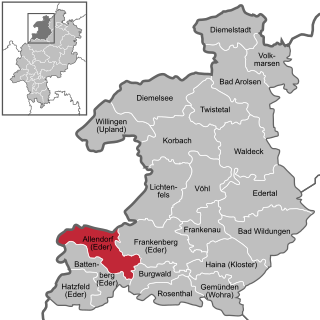
Allendorf (Eder) (German:[ˈaləndɔʁf] ) is a municipality which situated in the north west of Hesse, Germany. The municipality is within the Waldeck-Frankenberg district in a rural region called the upper Eder Valley. The Burgwald range is located west of Allendorf while the Breite Struth hills are in Allendorf's east.

Burgwald is a municipality in Waldeck-Frankenberg in Hesse, Germany.
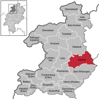
Edertal is a municipality in Waldeck-Frankenberg in northern Hesse, Germany.
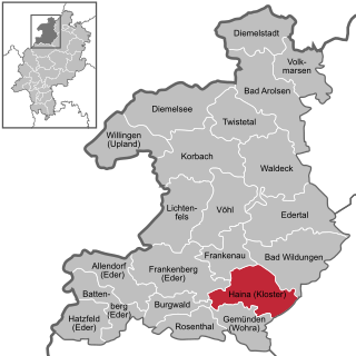
Haina (Kloster) is a municipality in Waldeck-Frankenberg in northwest Hesse, Germany.

The Sackpfeife is a mountain, 673.3 m above sea level (NHN),, in the Rothaar Mountains on the boundary of the counties of Waldeck-Frankenberg and Marburg-Biedenkopf in the German state of Hesse.