Rosenthal, Hesse

Last updated
Rosenthal
DEU Rosenthal COA.svg
Location of Rosenthal within Waldeck-Frankenberg district
Rosenthal in KB.svgBattenbergAllendorfRosenthalFrankenbergLichtenfelsDiemelseeWaldeck
Germany adm location map.svg
Red pog.svg
Rosenthal
Hesse location map.svg
Red pog.svg
Rosenthal
Coordinates: 50°58′N08°52′E / 50.967°N 8.867°E / 50.967; 8.867 Coordinates: 50°58′N08°52′E / 50.967°N 8.867°E / 50.967; 8.867
Country Germany
State Hesse
Admin. region Kassel
District Waldeck-Frankenberg
Subdivisions3 Ortsteile
Government
   Mayor (202127) Stefan Jakob [1] (CDU)
Area
  Total51.54 km2 (19.90 sq mi)
Elevation
294 m (965 ft)
Population
 (2020-12-31) [2]
  Total2,158
  Density42/km2 (110/sq mi)
Time zone UTC+01:00 (CET)
  Summer (DST) UTC+02:00 (CEST)
Postal codes
35119
Dialling codes 06458
Vehicle registration KB
Website www.rosenthaler.de

Rosenthal is a small town in southeast Waldeck-Frankenberg district in Hesse, Germany.

Contents

Geography

Location

Rosenthal lies in the Burgwald range 11 km southeast of Frankenberg and 18 km northeast of Marburg.

Neighbouring communities

Rosenthal borders in the north on the community of Burgwald, in the east on the town of Gemünden (both in Waldeck-Frankenberg), in the southeast on the community of Wohratal, in the south on the towns of Rauschenberg and Wetter, and in the west on the community of Münchhausen (all in Marburg-Biedenkopf).

Constituent communities

Besides the main town, which bears the same name as the whole, the town of Rosenthal consists of the centres of Roda and Willershausen.

History

Rosenthal was founded in 1327 as a Mainz town and outpost in the dispute over the Hessian fief, but nevertheless passed to the Landgraviate of Hesse in 1464.

In 1688, the town achieved dubious fame by being the scene of Hesse's last witch burnings.

In 1866, Rosenthal passed, along with the rest of the Electorate of Hesse, to Prussia.

Amalgamations

As part of Hesse's municipal reforms in the early 1970s, the heretofore independent communities of Roda and Willershausen were amalgamated with Rosenthal.

Politics

The Church in Rosenthal Rosenthal church.jpg
The Church in Rosenthal

Town council

The town council's 15 seats are apportioned thus, in accordance with municipal elections held on 26 March 2006:

CDU 7 seats
Bürgerliste Roda5 seats
FDP 3 seats

Note: Bürgerliste Roda is a citizens' coalition.

Mayor

At the mayoral election on 26 September 2021, Stefan Jakob was elected Rosenthal's mayor with a 82% share of the vote.

Rathaus from Rosenthal Rosenthal-Rathaus-vorne-links.jpg
Rathaus from Rosenthal

Coat of arms

Rosenthal's civic coat of arms might heraldically be described thus: In gules a six-spoked wheel argent surrounded per square by four roses Or with centres azure and sepals vert.

This describes the arms shown in this article, and also seen at the town's official website. At least one source, however, describes a different composition with three stemmed roses growing out of the top of the wheel.

The wheel is the Wheel of Mainz, symbolizing the town's founders.

Literature

Related Research Articles

Waldeck-Frankenberg is a Kreis (district) in the north of Hesse, Germany. Neighbouring districts are Höxter, Kassel, Schwalm-Eder, Marburg-Biedenkopf, Siegen-Wittgenstein, Hochsauerland.

<span class="mw-page-title-main">Münchhausen am Christenberg</span> Municipality in Hesse, Germany

The community of Münchhausen is found 20 km (12 mi) north of Marburg on the northern edge of Marburg-Biedenkopf district. It has 3,605 inhabitants and has had its current boundaries since 1974. The community's area is roughly 41 km².

<span class="mw-page-title-main">Wetter, Hesse</span> Town in Hesse, Germany

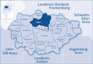
Wetter (Hessen) is a small town in Hesse, Germany. The rather unusual designation Wetter (Hessen-Nassau) stems from a time when the town belonged to the Prussian province of the same name, and nowadays is only used by the railway – even today, the railway station in town bears this name.

<span class="mw-page-title-main">Rauschenberg, Hesse</span> Town in Hesse, Germany

Rauschenberg is a town in the north of Marburg-Biedenkopf district in Hesse, Germany.

<span class="mw-page-title-main">Battenberg (Eder)</span> Town in Hesse, Germany

Battenberg (Eder) is a small town in Waldeck-Frankenberg district, the state of Hesse, Germany. The town is noted for giving its name to the Battenberg family, a morganatic branch of the ruling House of Hesse-Darmstadt, and through it, the name Mountbatten used by members of the British royal family, a literal translation of Battenberg.

<span class="mw-page-title-main">Hatzfeld</span> Town in Hesse, Germany

Hatzfeld (Eder) is a small town in Waldeck-Frankenberg district in Hesse, Germany.

<span class="mw-page-title-main">Twistetal</span> Municipality in Hesse, Germany

Twistetal is a community in Waldeck-Frankenberg in northwest Hesse, Germany, southwest of Bad Arolsen.

<span class="mw-page-title-main">Neustadt, Hesse</span> Town in Hesse, Germany

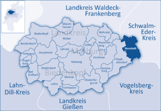
Neustadt is a town in the Marburg-Biedenkopf district in Hesse, Germany. For the town of the same name in Canada see Neustadt, Ontario.

<span class="mw-page-title-main">Lohra, Germany</span> Municipality in Hesse, Germany

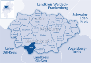
Lohra is a community in Marburg-Biedenkopf district in the administrative region of Gießen in Hesse, Germany.

<span class="mw-page-title-main">Cölbe</span> Municipality in Hesse, Germany

Cölbe is a community in Marburg-Biedenkopf district in Hesse, Germany.

<span class="mw-page-title-main">Steffenberg</span> Municipality in Hesse, Germany

Steffenberg is a municipality in Marburg-Biedenkopf district in Hesse, Germany.

<span class="mw-page-title-main">Wohratal</span> Municipality in Hesse, Germany

Wohratal is a community in Marburg-Biedenkopf district in Hessen, Germany.

<span class="mw-page-title-main">Frankenau</span> Town in Hesse, Germany

Frankenau is a small town in Waldeck-Frankenberg district in Hesse, Germany.

<span class="mw-page-title-main">Gemünden (Wohra)</span> Town in Hesse, Germany

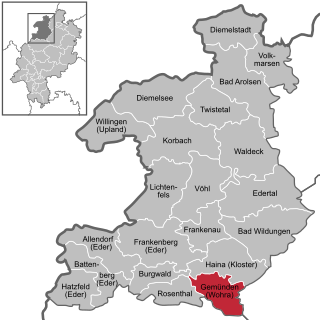
Gemünden is a town in Waldeck-Frankenberg district in Hesse, Germany.

<span class="mw-page-title-main">Allendorf (Eder)</span> Municipality in Hesse, Germany

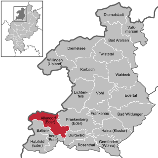
Allendorf (Eder) is a municipality which situated in the north west of Hesse, Germany. The municipality is within the Waldeck-Frankenberg district in a rural region called the upper Eder Valley. The Burgwald range is located west of Allendorf while the Breite Struth hills are in Allendorf's east.

<span class="mw-page-title-main">Bromskirchen</span> Municipality in Hesse, Germany

Bromskirchen is a community in Waldeck-Frankenberg in Hesse, Germany.

<span class="mw-page-title-main">Burgwald</span> Municipality in Hesse, Germany

Burgwald is a municipality in Waldeck-Frankenberg in Hesse, Germany.

<span class="mw-page-title-main">Diemelsee (municipality)</span> Municipality in Hesse, Germany

Diemelsee is a municipality in Waldeck-Frankenberg in northwest Hesse, Germany, and is part of the low mountain region called Upland. Adorf is the district seat of this municipality.

<span class="mw-page-title-main">Edertal</span> Municipality in Hesse, Germany

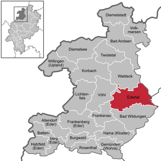
Edertal is a municipality in Waldeck-Frankenberg in northern Hesse, Germany.

<span class="mw-page-title-main">Haina</span> Municipality in Hesse, Germany

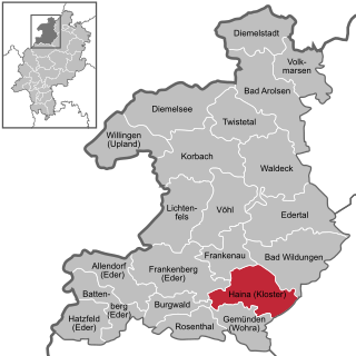
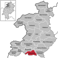
Haina (Kloster) is a community in Waldeck-Frankenberg in northwest Hesse, Germany.

References

  1. "Ergebnisse der letzten Direktwahl aller hessischen Landkreise und Gemeinden" (XLS) (in German). Hessisches Statistisches Landesamt. 5 September 2022.
  2. "Bevölkerung in Hessen am 31.12.2020 nach Gemeinden". Hessisches Statistisches Landesamt (in German). June 2021.