Rauschenberg, Hesse

Last updated
Rauschenberg
Wappen Rauschenberg (Hessen).svg
Coat of arms
Location of Rauschenberg within Marburg-Biedenkopf district
Marburg-Biedenkopf Rauschenberg.png
Germany adm location map.svg
Red pog.svg
Rauschenberg
Hesse location map.svg
Red pog.svg
Rauschenberg
Coordinates: 50°52′0″N8°55′0″E / 50.86667°N 8.91667°E / 50.86667; 8.91667 Coordinates: 50°52′0″N8°55′0″E / 50.86667°N 8.91667°E / 50.86667; 8.91667
Country Germany
State Hesse
Admin. region Gießen
District Marburg-Biedenkopf
Subdivisions7 Ortsteile
Government
   Mayor (201824) Michael Emmerich [1] (CDU)
Area
  Total67.33 km2 (26.00 sq mi)
Elevation
227 m (745 ft)
Population
 (2020-12-31) [2]
  Total4,410
  Density65/km2 (170/sq mi)
Time zone UTC+01:00 (CET)
  Summer (DST) UTC+02:00 (CEST)
Postal codes
35282
Dialling codes 06425
Vehicle registration MR
Website www.rauschenberg.de

Rauschenberg is a town in the north of Marburg-Biedenkopf district in Hesse, Germany.

Contents

Geography

Location

Rauschenberg lies at the southern edge of the Burgwald, a low mountain range, near Marburg and Kirchhain.

Neighbouring communities

Rauschenberg borders in the north on the town of Rosenthal (Waldeck-Frankenberg) as well as on the communities of Wohratal (Marburg-Biedenkopf) and Gilserberg (Schwalm-Eder-Kreis), in the east on the town of Stadtallendorf, in the south on the town of Kirchhain, in the southwest on the community of Cölbe, and in the west on the town of Wetter (all in Marburg-Biedenkopf).

Municipality divisions

Rauschenberg consists out of following villages:

History

Rauschenberg's town hall Rauschenberg City hall.jpg
Rauschenberg's town hall

Even as far back as 1000, a castle was built in what is now Rauschenberg. After a fire about 1250, almost the whole settlement was destroyed. Shortly after Rauschenberg was founded by the Counts of Ziegenhain, it was granted town rights. When the "von Ziegenhain" family died out in 1450, the castle and the town fell to the House of Hesse. In this time, the castle was expanded and made into a hunting lodge.

During the Thirty Years' War, Rauschenberg was mostly destroyed and thoroughly plundered by Swedish troops. Ever since the castle was blown up at a Kassel colonel's behest two years before the war ended, there has been nothing left of it but a ruin.

Politics

Town council

Results of municipal election on 6 March 2016:

Parties and voter coalitionsShare in %Seats
CDU Christian Democratic Union 26.16
SPD Social Democratic Party of Germany 23.15
Greens Alliance '90/The Greens 21.15
FBLFreie Bürgerliste (citizens' coalition)29.77
total10023

Coat of arms

Rauschenberg's civic coat of arms might be described thus: Party per fess; above, in sable a six-pointed star argent; below in Or. It matches the arms used by the town's old overlords, the Counts of Ziegenhain. [3] An eight-pointed star in a modification of the Counts coat of arms. [4]

Town partnership

Culture and Sightseeing

Buildings

There has not been much left of the castle, later stately home, of Rauschenberg since it was destroyed in the Thirty Years' War. The ruins on the hill over the constituent community – also known as Rauschenberg – are open and free to all.

Economy and infrastructure

Transport

Rauschenberg is connected to the road network by Federal Highway (Bundesstraße) B 3 between Frankfurt and Kassel, and by Bundesstraße B 62. As for public transportation, there is a bus connection to Kirchhain which runs many times daily.

Personalities

People born in Rauschenberg

Personalities who have lived or worked in Rauschenberg

In pop culture

A Finnish industrial music group, named Rauschenmaschine (German for noisemaschine) has a song on their website called Rauschenberg. [5]

Related Research Articles

Marburg-Biedenkopf is a Kreis (district) in the west of Hesse, Germany. Neighboring districts are Waldeck-Frankenberg, Schwalm-Eder, Vogelsbergkreis, Gießen, Lahn-Dill, Siegen-Wittgenstein.

Schwalm-Eder-Kreis is a Kreis (district) in the north of Hesse, Germany. Neighbouring districts are Kassel, Werra-Meißner, Hersfeld-Rotenburg, Vogelsberg, Marburg-Biedenkopf, and Waldeck-Frankenberg.

Waldeck-Frankenberg is a Kreis (district) in the north of Hesse, Germany. Neighbouring districts are Höxter, Kassel, Schwalm-Eder, Marburg-Biedenkopf, Siegen-Wittgenstein, Hochsauerland.

Wetter, Hesse Place in Hesse, Germany

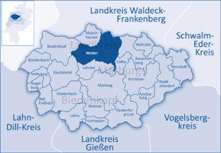
Wetter (Hessen) is a small town in Hesse, Germany. The rather unusual designation Wetter (Hessen-Nassau) stems from a time when the town belonged to the Prussian province of the same name, and nowadays is only used by the railway – even today, the railway station in town bears this name.

Lahntal Place in Hesse, Germany

The community of Lahntal is found in the Marburg-Biedenkopf district in northwest Middle Hesse, Germany.

Amöneburg Place in Hesse, Germany

Amöneburg is a town in the Marburg-Biedenkopf district in Hesse, Germany. It lies on a mountain and is built around the castle of the same name, Burg Amöneburg.

Ebsdorfergrund Place in Hesse, Germany

Ebsdorfergrund is a community consisting of eleven villages in the southeast of Marburg-Biedenkopf district in Hesse, Germany.

Kirchhain Place in Hesse, Germany

Kirchhain is a town in Marburg-Biedenkopf district in Hesse, Germany.

Stadtallendorf Place in Hesse, Germany

Stadtallendorf is a town in the county of Marburg-Biedenkopf, Hesse, Germany. It lies about 18 km east of Marburg. In 2010, the town hosted the 50th Hessentag state festival.

Lohra Place in Hesse, Germany

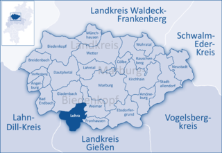
Lohra is a community in Marburg-Biedenkopf district in the administrative region of Gießen in Hesse, Germany.

Cölbe Place in Hesse, Germany

Cölbe is a community in Marburg-Biedenkopf district in Hesse, Germany.

Wohratal Place in Hesse, Germany

Wohratal is a community in Marburg-Biedenkopf district in Hessen, Germany.

Schwalmstadt Place in Hesse, Germany

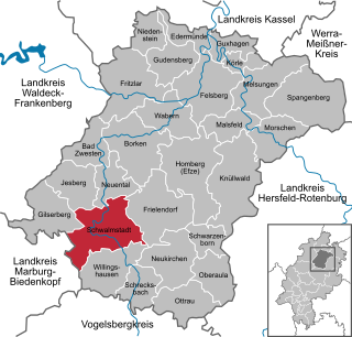
Schwalmstadt is the largest town in the Schwalm-Eder district, in northern Hesse, Germany. It was established only in 1970 with the amalgamation of the towns of Treysa and Ziegenhain together with some outlying villages to form the town of Schwalmstadt.

Melsungen Place in Hesse, Germany

Melsungen is a small climatic spa town in the Schwalm-Eder district in northern Hesse, Germany. In 1987, the town hosted the 27th Hessentag state festival.

Oberaula Place in Hesse, Germany

Oberaula is a community in the Schwalm-Eder district in Hesse, Germany.

Homberg (Ohm) Place in Hesse, Germany

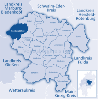
Homberg (Ohm) is a town in the Vogelsbergkreis in Hesse, Germany.

Kirtorf Place in Hesse, Germany

Kirtorf is a town in the northern Vogelsbergkreis in Hesse, Germany. Through the town runs the Deutsche Märchenstraße, or German Fairytale Road, a touristic route joining many of the places commonly associated with the Brothers Grimm's tales.

Bischoffen Place in Hesse, Germany

Bischoffen is a community in the Lahn-Dill-Kreis in Hesse, Germany.

Gemünden (Wohra) Place in Hesse, Germany

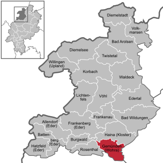
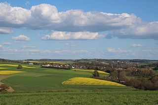
Gemünden is a town in Waldeck-Frankenberg district in Hesse, Germany.

Rosenthal, Hesse Place in Hesse, Germany

Rosenthal is a small town in southeast Waldeck-Frankenberg district in Hesse, Germany.

References

  1. Direkt gewählte (Ober-) Bürgermeister/-innen der hessischen Städte und Gemeinden, accessed 7 July 2021.
  2. "Bevölkerung in Hessen am 31.12.2020 nach Gemeinden". Hessisches Statistisches Landesamt (in German). June 2021.
  3. Hessisches Ortswappenbuch (1956, published by Verlag C. A. Starke, Limburg)
  4. http://www.ngw.nl/int/dld/r/rauschen.html International Civic Heraldry website
  5. "Rauschenmaschine".