Flanders is the Dutch-speaking northern portion of Belgium and one of the communities, regions and language areas of Belgium. However, there are several overlapping definitions, including ones related to culture, language, politics, and history, and sometimes involving neighbouring countries. The demonym associated with Flanders is Fleming, while the corresponding adjective is Flemish, which can also refer to the collective of Dutch dialects spoken in that area, or more generally the Belgian variant of Standard Dutch. The official capital of Flanders is the City of Brussels, although the Brussels-Capital Region that includes it has an independent regional government. The powers of the government of Flanders consist, among others, of economic affairs in the Flemish Region and the community aspects of Flanders life in Brussels, such as Flemish culture and education.

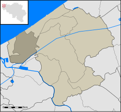
West Flanders is the westernmost province of the Flemish Region, in Belgium. It is the only coastal Belgian province, facing the North Sea to the northwest. It has land borders with the Dutch province of Zeeland to the northeast, the Flemish province of East Flanders to the east, the Walloon province of Hainaut in the south and the French department of Nord to the west. Its capital is Bruges (Brugge). Other important cities are Kortrijk in the south and Ostend (Oostende) on the coast, Roeselare and Ypres (Ieper). The province has an area of 3,197 km2 (1,234 sq mi) which is divided into eight administrative districts (arrondissementen) containing 64 municipalities. As of January 2019, West Flanders has a population of 1,195,796.

Bredene is a municipality located in the Belgian province of West Flanders. The municipality only comprises the town of Bredene proper. On 1 January 2006, Bredene had a total population of 15,118. The total area is 13.08 km2 which gives a population density of 1156 inhabitants per km2.

Zeelandic Flanders is the southernmost region of the province of Zeeland in the south-western Netherlands. It lies south of the Western Scheldt that separates the region from the remainder of Zeeland and the Netherlands to the north. Zeelandic Flanders is bordered to the south and to the east by Belgium.
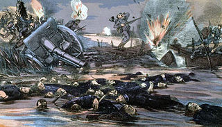
The Battle of the Yser was a battle of the First World War that took place in October 1914 between the towns of Nieuwpoort and Diksmuide, along a 35 km (22 mi) stretch of the Yser River and the Yperlee Canal, in Belgium. The front line was held by a large Belgian force, which halted the German advance in a costly defensive battle.
Testerep once comprised an island along the Belgian coast. It existed as early as the 10th century. Fishing villages were scattered about, including Ostend and Westende, with Ostend on the far east, Westende on the far west, and Middelkerke the middle of the island. Later, canals and dikes were built and the island became connected to the West Flanders mainland.

Knokke is a town in the municipality of Knokke-Heist, which is located in the province of West Flanders in Flanders, Belgium. The town itself has 15,708 inhabitants (2007), while the municipality of Knokke-Heist has 33,818 inhabitants (2009).

The Yser Towers are a monument complex near the Yser river at Diksmuide, West Flanders in Belgium. The first tower was built in 1928–30 to commemorate the Belgian soldiers killed on the surrounding Yser Front during World War I and as a monument to Christian pacifism. However, it subsequently became an important political symbol for the Flemish Movement and was destroyed in 1946 as a result of its association with Flemish nationalist collaboration in German-occupied Belgium in World War II. The current tower was rebuilt alongside the remains of the original and copied its design. It was finished in 1965. It remains a site of political significance to Flemish nationalists and is the center for their annual Yser Pilgrimage (IJzerbedevaart).

Oostduinkerke is a place in the Belgian province of West Flanders, where it is located on the southern west coast of Belgium.

Loppem Castle is a mansion situated in Loppem in the municipality of Zedelgem, near Bruges in West Flanders, in the Flemish Region of Belgium.

Westhoek or Maritime Flanders is a region in Belgium and France and includes the following areas:
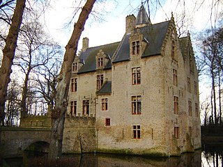
Beauvoorde Castle is a castle in Wulveringem, which since 1977 has been part of the municipality of Veurne, West Flanders, Belgium.

The N8 road in Belgium is a road connecting Brussels and Koksijde, passing Ninove, Oudenaarde, Kortrijk, Ypres and Veurne.
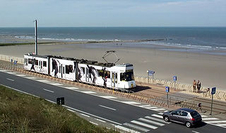
Raversijde is a neighborhood and former parish of the West Flemish town of Ostend. It is adjacent to Middelkerke, another neighborhood, which is located on the North Sea coast. Raversijde is located on the Kusttram, which is the coastal tramway.

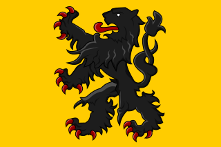
Flemish (Vlaams) is a Low Franconian dialect cluster of the Dutch language. It is sometimes referred to as Flemish Dutch, Belgian Dutch, or Southern Dutch. Flemish is native to the region known as Flanders in northern Belgium; it is spoken by Flemings, the dominant ethnic group of the region. Outside of Belgium Flanders, it is also spoken to some extent in French Flanders and the Dutch Zeelandic Flanders.

The Belgium–France border, or more commonly the Franco-Belgian border, separates France and Belgium and is 620 km (390 mi) long. Part of it is defined by the Lys river. The western end is at the North Sea. The eastern end is at the Belgium–France–Luxembourg tripoint. The straight distance between these points is 289 km (180 mi).

The Yser Front, sometimes termed the West Flemish Front in British writing, was a section of the Western Front during World War I held by Belgian troops from October 1914 until 1918. The front ran along the Yser river (IJzer) and Yser Canal (Ieperlee) in the far north-west of Belgium and defended a small strip of the country which remained unoccupied. The front was established following the Battle of the Yser in October 1914, when the Belgian army succeeded in stopping the German advance after months of retreat and remained largely static for the duration of the war.
The County of Flanders was one of the most powerful political entities in the medieval Low Countries, located on the North Sea coast of what is now Belgium. Unlike its neighbours, such as the counties of Brabant and Hainaut, it was within the territory of the Kingdom of France. The counts of Flanders held the most northerly part of the kingdom, and were among the original twelve peers of France. For centuries, the economic activity of the Flemish cities, such as Ghent, Bruges and Ypres, made Flanders one of the most affluent regions in Europe, and also gave them strong international connections to trading partners.

The Lange Max Museum (LMM) is devoted to the German 38 cm SK L/45 "Max" gun and the German occupation of Koekelare and the nearby area in World War I. The focus on the German side of the war makes it a unique museum in Belgium. The museum is named after the nickname of the German gun "Lange Max", which was one of the biggest guns in the world in 1917, and is located in Koekelare.

The Flanders Fields Memorial Garden is a monument dedicated to the participants of World War I situated alongside the Guards Chapel at Wellington Barracks in Central London, England.