
The Eastern Scheldt is a former estuary in the province of Zeeland, Netherlands, between Schouwen-Duiveland and Tholen on the north and Noord-Beveland and Zuid-Beveland on the south. It also features the largest national park in the Netherlands, founded in 2002.

Sylt is an island in northern Germany, part of Nordfriesland district, Schleswig-Holstein, well known for the distinctive shape of its shoreline. It belongs to the North Frisian Islands and is the largest island in North Frisia. The northernmost island of Germany, it is known for its tourist resorts, notably Westerland, Kampen and Wenningstedt-Braderup, as well as for its 40-kilometre-long (25-mile) sandy beach. It is frequently covered by the media in connection with its exposed situation in the North Sea and its ongoing loss of land during storm tides. Since 1927, Sylt has been connected to the mainland by the Hindenburgdamm causeway. In later years, it has been a resort for the German jet set and tourists in search of occasional celebrity sightings.

West Flanders is the westernmost province of the Flemish Region, in Belgium. It is the only coastal Belgian province, facing the North Sea to the northwest. It has land borders with the Dutch province of Zeeland to the northeast, the Flemish province of East Flanders to the east, the Walloon province of Hainaut in the south and the French department of Nord to the west. Its capital is Bruges (Brugge). Other important cities are Kortrijk in the south and Ostend (Oostende) on the coast, Roeselare and Ypres (Ieper). The province has an area of 3,197 km2 (1,234 sq mi) which is divided into eight administrative districts (arrondissementen) containing 64 municipalities. As of January 2024, West Flanders has a population of over 1.22 million.

Nieuwpoort is a city and municipality located in Flanders, one of the three regions of Belgium, in the province of West Flanders. The municipality comprises the town of Nieuwpoort proper, as well as Ramskapelle and Sint-Joris. On 1 January 2008, Nieuwpoort had a total population of 11,062. Its land area is 31.00 km² which gives a population density of 350 inhabitants per km². The current mayor of Nieuwpoort is Geert Vanden Broucke (CD&V)

Barrier islands are a coastal landform, a type of dune system and sand island, where an area of sand has been formed by wave and tidal action parallel to the mainland coast. They usually occur in chains, consisting of anything from a few islands to more than a dozen. They are subject to change during storms and other action, but absorb energy and protect the coastlines and create areas of protected waters where wetlands may flourish. A barrier chain may extend for hundreds of kilometers, with islands periodically separated by tidal inlets. The largest barrier island in the world is Padre Island of Texas, United States, at 113 miles (182 km) long. Sometimes an important inlet may close permanently, transforming an island into a peninsula, thus creating a barrier peninsula, often including a beach, barrier beach. Though many are long and narrow, the length and width of barriers and overall morphology of barrier coasts are related to parameters including tidal range, wave energy, sediment supply, sea-level trends, and basement controls. The amount of vegetation on the barrier has a large impact on the height and evolution of the island.

The Bristol Channel is a major inlet in the island of Great Britain, separating South Wales and South West England. It extends from the smaller Severn Estuary of the River Severn to the North Atlantic Ocean. It takes its name from the English city and port of Bristol.

The Yser is a river that rises in French Flanders, enters the Belgian province of West Flanders and flows through the Ganzepoot and into the North Sea at the town of Nieuwpoort.

The Frisian Islands, also known as the Wadden Islands or the Wadden Sea Islands, form an archipelago at the eastern edge of the North Sea in northwestern Europe, stretching from the northwest of the Netherlands through Germany to the west of Denmark. The islands shield the mudflat region of the Wadden Sea from the North Sea.
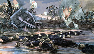
The Battle of the Yser was a battle of the First World War that took place in October 1914 between the towns of Nieuwpoort and Diksmuide, along a 35 km (22 mi) stretch of the Yser River and the Yperlee Canal, in Belgium. The front line was held by a large Belgian force, which halted the German advance in a costly defensive battle.

Stuivekenskerke is a district of the town of Diksmuide, in the Belgian province of West Flanders. Located on the Yser river, until 1970 it was an independent municipality and then merged and became a sub-municipality of Diksmuide. Stuivekenskerke, built in a polder, has an area of 7.34 km2 and had 160 inhabitants in 2007.

The River Taw in England rises at Taw Head, a spring on the central northern flanks of Dartmoor, crosses North Devon and at the town of Barnstaple, formerly a significant port, empties into Bideford Bay in the Bristol Channel, having formed a large estuary of wide meanders which at its western end is the estuary of the River Torridge.

Mandø or Manø is one of the Danish Wadden Sea islands off the southwest coast of Jutland, Denmark in the Wadden Sea, part of the North Sea. The island covers an area of 7.63 square kilometres and had between 27-31 inhabitants in January 2022. The island is part of Esbjerg Municipality and is situated approximately 12 kilometres southwest of the ancient town of Ribe.

Baltrum is a barrier island off the coast of East Frisia, in Germany, and is a municipality in the district of Aurich, Lower Saxony. It is located in-between the chain of the seven inhabited East Frisian Islands. Baltrum is the smallest island in this chain by area and inhabitants. It has a land area of 6.5 square kilometres, and a population in (2011) of just over 500 resident inhabitants.

Operation Hush was a British plan to make amphibious landings on the Belgian coast in 1917 during the First World War, supported by an attack from Nieuwpoort and the Yser bridgehead, positions which were a legacy of the Battle of the Yser in 1914. Several plans were considered in 1915 and 1916, then shelved due to operations elsewhere. Operation Hush was intended to begin when the Third Battle of Ypres, the main offensive at Ypres, had advanced to Roulers, Koekelare and Thourout, linked by advances by the French and Belgian armies in between.

The Chincoteague National Wildlife Refuge is a 14,000-acre (57 km2) wildlife preserve operated by the U.S. Fish & Wildlife Service. It is primarily located on the Virginia half of Assateague Island with portions located on the Maryland side of the island, as well as Morris Island and Wildcat Marsh. Mostly composed of beach, dunes, marsh, and maritime forest, the refuge contains a large variety of wildlife, including the Chincoteague pony. The purpose of the refuge is to maintain, regulate, and preserve animal and plant species as well as their habitats for present and future generations.
Joris Carolus was a Dutch cartographer and explorer who was employed by the Noordsche Compagnie and the Dutch East India Company.
Wenduine is a seaside resort on the Belgian North Sea coast. It is a village with a population of 4000 inhabitants in the West-Flemish municipality of De Haan.

The December 1992 nor'easter produced record high tides and snowfall across the northeastern United States. It developed as a low pressure area on December 10 over Virginia, and for two days it remained over the Mid-Atlantic states before moving offshore. In Maryland, the snowfall unofficially reached 48 in (1,200 mm); if verified, the total would have been the highest in the state's history. About 120,000 people were left without power in the state due to high winds. Along the Maryland coast, the storm was less severe than the Perfect Storm in the previous year, although the strongest portion of the storm remained over New Jersey for several days. In the state, winds reached 80 mph (130 km/h) in Cape May, and tides peaked at 10.4 ft (3.2 m) in Perth Amboy. The combination of high tides and 25 ft (7.6 m) waves caused the most significant flooding in the state since the Ash Wednesday Storm of 1962. Several highways and portions of the New York City Subway and Port Authority Trans-Hudson systems were closed due to the storm. Throughout New Jersey, the nor'easter damaged about 3,200 homes and caused an estimated $750 million in damage (1992 USD).

A gat is an inshore channel or strait connecting coastal waters with the open sea or dividing two landmasses, such as two islands or an island and a peninsula. Gats are usually relatively narrow but deep and are in many instances constantly eroded by currents flowing back and forth, such as tidal currents. The term is mostly used for features on the North Sea and Baltic Sea coasts.

Cyclone Xaver, also known as the North Sea flood or tidal surge of 2013, was a winter storm that affected northern Europe. Force 12 winds and heavy snowfall were predicted along the storm's path, and there were warnings of a significant risk of storm surge leading to coastal flooding along the coasts of the North and Irish Seas.

