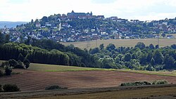
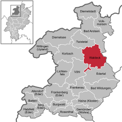
Waldeck, Hesse

Last updated
Waldeck
Waldeck, KB - Netze ostl - Waldeck v NO.jpg
Waldeck seen from the northeast
DEU Waldeck (am Edersee) COA.svg
Location of Waldeck within Waldeck-Frankenberg district
Waldeck in KB.svgBattenbergAllendorfRosenthalFrankenbergLichtenfelsWaldeck
Germany adm location map.svg
Red pog.svg
Waldeck
Hesse location map.svg
Red pog.svg
Waldeck
Coordinates: 51°12′N09°4′E / 51.200°N 9.067°E / 51.200; 9.067 Coordinates: 51°12′N09°4′E / 51.200°N 9.067°E / 51.200; 9.067
Country Germany
State Hesse
Admin. region Kassel
District Waldeck-Frankenberg
Subdivisions10 Stadtteile
Government
   Mayor (201824) Jürgen Vollbracht [1] (CDU)
Area
  Total115.73 km2 (44.68 sq mi)
Highest elevation
475 m (1,558 ft)
Lowest elevation
245 m (804 ft)
Population
 (2020-12-31) [2]
  Total6,743
  Density58/km2 (150/sq mi)
Time zone UTC+01:00 (CET)
  Summer (DST) UTC+02:00 (CEST)
Postal codes
34513
Dialling codes 05634
Vehicle registration KB
Website www.waldeck.de

Waldeck is a small town in Waldeck-Frankenberg district in northwestern Hesse, Germany. Its located near the Edersee, which is a popular destination for tourists and locals alike.

Contents

Geography

Location

Waldeck lies on the Edersee, a man-made lake. Waldeck's constituent communities stretch from the shore of the Edersee into the Kellerwald.

Neighbouring communities

Waldeck borders in the north on the community of Twistetal, in the northeast on the town of Bad Arolsen (both in Waldeck-Frankenberg), in the east on the towns of Wolfhagen and Naumburg (both in the district of Kassel), in the south on the community of Edertal, and in the west on the community of Vöhl and the town of Korbach (all three in Waldeck-Frankenberg).

Constituent communities

The town of Waldeck consists of the centres of Alraft, Dehringhausen, Freienhagen, Höringhausen, Netze, Nieder-Werbe, Ober-Werbe, Sachsenhausen, Selbach and Waldeck.

History

The first evidence of settlement at Waldeck comes from the year 1232 when a document from the Netze Monastery mentioned the universitas civitatis de waldeke. Until 1254, the town was also called Rode, possibly because there was a clearing there. The town's first seal was acquired in 1266, and the town had its first historically verifiable mayor in 1311. Until the beginning of the 20th century, Waldeck's population barely exceeded 400.

Waldeck was the residence of the Counts of Waldeck who, beginning around 1200, gradually gathered a sizeable realm under their control and, having added the county of Pyrmont to their holdings through inheritance, were elevated to Princes of Waldeck-Pyrmont in 1712. In 1655, the residence was transferred to Arolsen, and Waldeck lost its importance.

The Edersee, Germany's third largest reservoir, was created by the construction of the Eder dam in 1914. The dam, designed to help regulate water levels for shipping on the Weser and to generate hydroelectricity, was destroyed by the RAF on 17 May 1943 (see Operation Chastise), causing massive flooding and loss of life downstream, but was rebuilt.

Freienhagen

Until municipal reforms in 1974, Freienhagen was a town in its own right. It already had town rights when history first mentioned the town in 1253; it is believed that they were granted in 1231. On the Hünenburg, a 472 m-high mountain in the Freienhagen Municipal Forest, traces of a prehistoric settlement have been found.

In the Middle Ages, Freienhagen had a complete ring of walls with two town gates through which led the old trade road from Cologne to Leipzig. Likewise historically interesting is the Freienhagen Free Court (Freienhagener Freigericht), which sat at first at the Schiebenscheid and later under the linden tree at the Steinborn. Under the Free Counts (Freigrafen – chairmen of the court) Sigmund Manegold (1435–1455) and Johann Manhoff (1438–1458), the court reached its greatest importance: the Teutonic Knights, and the cities of Frankfurt and Cologne, were referred to Freienhagen.

Amalgamations

As part of municipal reforms, the greater town of Waldeck was formed out of the formerly independent communities of Alraft, Höringhausen, Netze, Nieder-Werbe, Selbach, Sachsenhausen and Waldeck. In 1974, Dehringhausen, Freienhagen and Ober-Werbe also joined the town.

Politics

Town council

The town council's 31 seats are apportioned thus, in accordance with municipal elections held on 6 March 2016:

SPD 8 seats
CDU 10 seats
FWG6 seats
FDP 3 seats
Greens 4 seat

Note: FWG is a citizens' coalition.

The town's executive consists of 7 councillors. Three of these seats are held by the SPD, 2 by the CDU, and one seat each by the FWG and the FDP.

Mayoral elections are held every six years. The most recent mayors were: [1]

Coat of arms

The official blazon roughly translates thus: In Or a six-pointed star sable.

This simply describes a black six-pointed star on a gold background, with no mention at all of the fleur-de-lys. Furthermore, Waldeck's official Internet presence does not contain any text about the civic coat of arms, although it does display the version with the lily. At least one source, however, shows arms for Waldeck matching the blazon.

According to this same source, the star was originally eight-pointed, as commonly appears in many civic arms in the Waldeck region. It is an heraldic charge once borne by the Counts of Waldeck in the Middle Ages. The number of points was changed in the 19th century to distinguish the town's arms from the district's.

Town partnerships

Culture and sightseeing

Museums

Buildings

Edersee Dam (Edertalsperre) Edersee, Staumauer, 2011-08 CN-01.jpg
Edersee Dam (Edertalsperre)

Parks

Sport

Economy and infrastructure

Transport

Through the town run the Federal Highways (Bundesstraßen) B 251 and B 485.

Operations on the stretch of the Ederseebahn railway line between Bad Wildungen and Korbach, on which lies Waldeck, ceased on 27 May 1995.

There is a cableway to the Edersee and well built hiking trails in the Kellerwald-Edersee National Park.

Related Research Articles

Waldeck-Frankenberg is a Kreis (district) in the north of Hesse, Germany. Neighbouring districts are Höxter, Kassel, Schwalm-Eder, Marburg-Biedenkopf, Siegen-Wittgenstein, Hochsauerland.

Ingelheim am Rhein Town in Rhineland-Palatinate, Germany

Ingelheim, officially Ingelheim am Rhein, is a town in the Mainz-Bingen district in the Rhineland-Palatinate state of Germany. The town sprawls along the Rhine's west bank. It has been Mainz-Bingen's district seat since 1996.

Lichtenfels, Hesse Town in Hesse, Germany

Lichtenfels is a small town in Waldeck-Frankenberg district in northwest Hesse, Germany.

Bad Arolsen Place in Hesse, Germany

Bad Arolsen is a small town in northern Hesse, Germany, in Waldeck-Frankenberg district. From 1655 until 1918 it served as the residence town of the Princes of Waldeck-Pyrmont and then until 1929 as the capital of the Waldeck Free State. The International Tracing Service has its headquarters in Bad Arolsen. In 2003, the town hosted the 43rd Hessentag state festival.

Korbach Town in Hesse, Germany

Korbach, officially the Hanseatic City of Korbach, is the district seat of Waldeck-Frankenberg in northern Hesse, Germany. It is over a thousand years old and is located on the German Timber-Frame Road. In 2018, the town has hosted the 58th Hessentag state festival.

Twistetal Municipality in Hesse, Germany

Twistetal is a community in Waldeck-Frankenberg in northwest Hesse, Germany, southwest of Bad Arolsen.

Willingen Municipality in Hesse, Germany

Willingen is a community in Waldeck-Frankenberg in northern Hesse, Germany, some 80 km west of Kassel.

Wohratal Municipality in Hesse, Germany

Wohratal is a community in Marburg-Biedenkopf district in Hessen, Germany.

Bad Zwesten Municipality in Hesse, Germany

Bad Zwesten is a community in the Schwalm-Eder district of Hesse, Germany.

Bad Wildungen Town in Hesse, Germany

Bad Wildungen, officially the City of Bad Wildungen, is a state-run spa and a small town in Waldeck-Frankenberg district in Hesse, Germany. It is located on the German Timber-Frame Road.

Diemelstadt Town in Hesse, Germany

Diemelstadt is a small town in Waldeck-Frankenberg district in Hesse, Germany.

Frankenau Town in Hesse, Germany

Frankenau is a small town in Waldeck-Frankenberg district in Hesse, Germany.

Gemünden (Wohra) Town in Hesse, Germany

Gemünden is a town in Waldeck-Frankenberg district in Hesse, Germany.

Volkmarsen Town in Hesse, Germany

Volkmarsen[ˈfɔlkˌmaʁzn̩] is a small town in Waldeck-Frankenberg district in northern Hesse, Germany. It is home to 6840 residents.

Burgwald Municipality in Hesse, Germany

Burgwald is a community in Waldeck-Frankenberg in Hesse, Germany.

Diemelsee (municipality) Municipality in Hesse, Germany

Diemelsee is a municipality in Waldeck-Frankenberg in northwest Hesse, Germany, and is part of the low mountain region called Upland. Adorf is the district seat of this municipality.

Edertal Municipality in Hesse, Germany

Edertal is a municipality in Waldeck-Frankenberg in northern Hesse, Germany.

Vöhl Municipality in Hesse, Germany

Vöhl is a community in Waldeck-Frankenberg in Hesse, Germany, not far southwest of Kassel.

Henry VIII (1465–1513) was a count of Waldeck and the founder of the older line of Waldeck-Wildungen. He was also temporarily governor of the County of Vianden, a possession of the House of Nassau.

Wabern–Brilon Wald railway

The Wabern–Brilon Wald railway is a 86.7 kilometre-long, single-track, partially disused secondary railway line from Wabern in North Hesse to Brilon-Wald in North Rhine-Westphalia.

References

  1. 1 2 Direkt gewählte (Ober-) Bürgermeister/-innen der hessischen Städte und Gemeinden, accessed 7 July 2021.
  2. "Bevölkerung in Hessen am 31.12.2020 nach Gemeinden". Hessisches Statistisches Landesamt (in German). June 2021.