Edertal

Last updated
Edertal
DEU Edertal COA.svg
Location of Edertal within Waldeck-Frankenberg district
Edertal in KB.svgBattenbergAllendorfRosenthalFrankenbergLichtenfelsDiemelseeWaldeck
Germany adm location map.svg
Red pog.svg
Edertal
Hesse location map.svg
Red pog.svg
Edertal
Coordinates: 51°10′N09°06′E / 51.167°N 9.100°E / 51.167; 9.100 Coordinates: 51°10′N09°06′E / 51.167°N 9.100°E / 51.167; 9.100
Country Germany
State Hesse
Admin. region Kassel
District Waldeck-Frankenberg
Government
   Mayor (201824) Klaus Gier [1] (Ind.)
Area
  Total115.72 km2 (44.68 sq mi)
Elevation
226 m (741 ft)
Population
 (2021-12-31) [2]
  Total6,211
  Density54/km2 (140/sq mi)
Time zone UTC+01:00 (CET)
  Summer (DST) UTC+02:00 (CEST)
Postal codes
34549
Dialling codes 05623, 05621
Vehicle registration KB
Website www.edertal.de

Edertal is a municipality in Waldeck-Frankenberg in northern Hesse, Germany.

Contents

Geography

Location

Edertal lies roughly 30 km in a straight line southwest of Kassel. It is on the north and northwest edges of the Kellerwald range and stretches to the south shore of the Edersee and south and southwest of its dam. It lies at the eastern edge of the Kellerwald-Edersee National Park, a small part of which is inside municipal limits.

The community of Edertal is crossed by the river Eder, the biggest body of flowing water in the community, from northwest to southeast. Into this empties the Wesebach at the constituent community of Giflitz. The Affolderner See, which is found within municipal limits, is another reservoir used as lower reservoir for the Waldeck Pumped Storage Station (one of Germany's largest hydro power stations) and for recreation.

On the whole, hydroelectric use at the Edersee is also well developed.

Neighbouring communities

Edertal borders in the north on the town of Waldeck, in the east on the towns of Naumburg (Kassel district) and Fritzlar (Schwalm-Eder-Kreis), in the south on the town of Bad Wildungen, and in the west on the town of Frankenau and the community of Vöhl (all three in Waldeck-Frankenberg).

Constituent communities

In Giflitz is the community's administrative seat. With the neighbouring centre of Bergheim to the northeast, it forms the heart of the community and, accordingly, a lower centre in the Regional Plan (in terms of Walter Christaller's Central Place Theory).

The community of Edertal consists of the following centres:

  • Affoldern
  • Anraff
  • Bergheim
  • Böhne
  • Bringhausen
  • Buhlen
  • Gellershausen
  • Giflitz
  • Hemfurth-Edersee
  • Kleinern
  • Königshagen
  • Mehlen
  • Wellen

Bringhausen was one of three villages that originally stood where the Edersee is now. It was relocated to higher ground early in the 20th century.

Geology

The area belongs to the foothills of the Rhenish Slate Mountains. Outcrops here are mainly shale and greywacke.

Politics

Municipal council

Edertal's council is made up of 31 councillors, with seats apportioned thus, in accordance with municipal elections held on 26 March 2006:

SPD 14 seats
CDU 9 seats
FWG5 seats
FDP 3 seats

Note: FWG is a citizens' coalition.

Mayor

In November 2012 Klaus Gier (independent) was elected the new mayor. [4]

Related Research Articles

Schwalm-Eder-Kreis is a Kreis (district) in the north of Hesse, Germany. Neighbouring districts are Kassel, Werra-Meißner, Hersfeld-Rotenburg, Vogelsberg, Marburg-Biedenkopf, and Waldeck-Frankenberg.

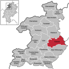
Waldeck-Frankenberg is a Kreis (district) in the north of Hesse, Germany. Neighbouring districts are Höxter, Kassel, Schwalm-Eder, Marburg-Biedenkopf, Siegen-Wittgenstein, Hochsauerland.

<span class="mw-page-title-main">Rauschenberg, Hesse</span> Town in Hesse, Germany

Rauschenberg is a town in the north of Marburg-Biedenkopf district in Hesse, Germany.

<span class="mw-page-title-main">Lichtenfels, Hesse</span> Town in Hesse, Germany

Lichtenfels is a small town in Waldeck-Frankenberg district in northwest Hesse, Germany.

<span class="mw-page-title-main">Waldeck, Hesse</span> Town in Hesse, Germany

Waldeck is a small town in Waldeck-Frankenberg district in northwestern Hesse, Germany. Its located near the Edersee, which is a popular destination for tourists and locals alike.

<span class="mw-page-title-main">Battenberg (Eder)</span> Town in Hesse, Germany

Battenberg (Eder) is a small town in Waldeck-Frankenberg district, the state of Hesse, Germany. The town is noted for giving its name to the Battenberg family, a morganatic branch of the ruling House of Hesse-Darmstadt, and through it, the name Mountbatten used by members of the British royal family, a literal translation of Battenberg.

<span class="mw-page-title-main">Korbach</span> Town in Hesse, Germany

Korbach, officially the Hanseatic City of Korbach, is the district seat of Waldeck-Frankenberg in northern Hesse, Germany. It is over a thousand years old and is located on the German Timber-Frame Road. In 2018, the town has hosted the 58th Hessentag state festival.

<span class="mw-page-title-main">Twistetal</span> Municipality in Hesse, Germany

Twistetal is a municipality in Waldeck-Frankenberg in northwest Hesse, Germany, southwest of Bad Arolsen.

<span class="mw-page-title-main">Willingen</span> Municipality in Hesse, Germany

Willingen is a municipality in Waldeck-Frankenberg in northern Hesse, Germany, some 80 km west of Kassel.

<span class="mw-page-title-main">Wohratal</span> Municipality in Hesse, Germany

Wohratal is a municipality in Marburg-Biedenkopf district in Hessen, Germany.

<span class="mw-page-title-main">Bad Zwesten</span> Municipality in Hesse, Germany

Bad Zwesten is a municipality in the Schwalm-Eder district of Hesse, Germany.

<span class="mw-page-title-main">Bad Wildungen</span> Town in Hesse, Germany

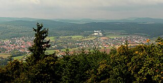
Bad Wildungen is a state-run spa and a small town in Waldeck-Frankenberg district in Hesse, Germany. It is located on the German Timber-Frame Road.

<span class="mw-page-title-main">Frankenau</span> Town in Hesse, Germany

Frankenau is a small town in Waldeck-Frankenberg district in Hesse, Germany.

<span class="mw-page-title-main">Gemünden (Wohra)</span> Town in Hesse, Germany

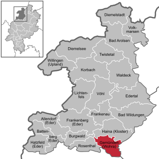
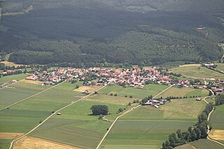
Gemünden is a town in Waldeck-Frankenberg district in Hesse, Germany.

<span class="mw-page-title-main">Volkmarsen</span> Town in Hesse, Germany

Volkmarsen[ˈfɔlkˌmaʁzn̩] is a small town in Waldeck-Frankenberg district in northern Hesse, Germany. It is home to 6840 residents.

<span class="mw-page-title-main">Bromskirchen</span> Municipality in Hesse, Germany

Bromskirchen is a municipality in Waldeck-Frankenberg in Hesse, Germany.

<span class="mw-page-title-main">Burgwald</span> Municipality in Hesse, Germany

Burgwald is a municipality in Waldeck-Frankenberg in Hesse, Germany.

<span class="mw-page-title-main">Diemelsee (municipality)</span> Municipality in Hesse, Germany

Diemelsee is a municipality in Waldeck-Frankenberg in northwest Hesse, Germany, and is part of the low mountain region called Upland. Adorf is the seat of this municipality.

<span class="mw-page-title-main">Haina</span> Municipality in Hesse, Germany

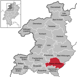
Haina (Kloster) is a municipality in Waldeck-Frankenberg in northwest Hesse, Germany.

<span class="mw-page-title-main">Vöhl</span> Municipality in Hesse, Germany

Vöhl is a municipality in Waldeck-Frankenberg in Hesse, Germany, not far southwest of Kassel.

References

  1. "Ergebnisse der letzten Direktwahl aller hessischen Landkreise und Gemeinden" (XLS) (in German). Hessisches Statistisches Landesamt. 5 September 2022.
  2. "Die Bevölkerung der hessischen Gemeinden am 31. Dezember 2021" (PDF) (in German). Hessisches Statistisches Landesamt. June 2022.
  3. "Ergebnis der Gemeindewahl am 6. März 2016". Hessisches Statistisches Landesamt. April 2016.
  4. "Klaus Gier mit 54,5 Prozent gewählt – Video".