Waldeck-Frankenberg is a Kreis (district) in the north of Hesse, Germany. Neighbouring districts are Höxter, Kassel, Schwalm-Eder, Marburg-Biedenkopf, Siegen-Wittgenstein, Hochsauerland.

The Lahn is a 245.6-kilometre-long (152.6 mi), right tributary of the Rhine in Germany. Its course passes through the federal states of North Rhine-Westphalia (23.0 km), Hesse (165.6 km), and Rhineland-Palatinate (57.0 km).

The Eder is a 177-kilometre (110 mi)-long major river in Germany that begins in eastern North Rhine-Westphalia and passes in to Hesse, where it empties into the River Fulda.

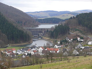
The Edersee Dam is a hydroelectric dam spanning the Eder river in northern Hesse, Germany. Constructed between 1908 and 1914, it lies near the small town of Waldeck at the northern edge of the Kellerwald. Breached by Allied bombs during World War II, it was rebuilt during the war, and today generates hydroelectric power and regulates water levels for shipping on the Weser river.

Waldeck is a small town in Waldeck-Frankenberg district in northwestern Hesse, Germany. Its located near the Edersee, which is a popular destination for tourists and locals alike.

Battenberg (Eder) is a small town in the district of Waldeck-Frankenberg in the state of Hesse, Germany. It is located on the river Eder, a tributary of the Fulda, which flows into the Weser, and lies at the southeastern edges of the Rothaar Mountains. The closest larger cities are Marburg, Siegen, and Kassel, and the town is approximately equally far away from Frankfurt am Main, Cologne, and Dortmund.

Frankenau is a small town in Waldeck-Frankenberg district in Hesse, Germany.

Burgwald is a municipality in Waldeck-Frankenberg in Hesse, Germany.
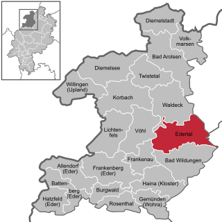
Edertal is a municipality in Waldeck-Frankenberg in northern Hesse, Germany.
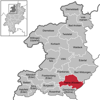
Haina (Kloster) is a municipality in Waldeck-Frankenberg in northwest Hesse, Germany.

Vöhl is a municipality in Waldeck-Frankenberg in Hesse, Germany, not far southwest of Kassel.

The Kellerwald is a low mountain range reaching heights of up to 675 m in the western part of northern Hesse, Germany. Its assets include Germany's largest contiguous beech woodland and it contains Hesse's only national park, the Kellerwald-Edersee National Park. It is a UNESCO World Heritage Site.

The West Hesse Highlands, also known as the West Hessian Lowlands and Highlands, are a heavily forested region of the Central Uplands in Germany. These highlands lie mainly within the state of Hesse, between that part of the Rhenish Massif right of the Rhine in the west, the Weser Uplands to the north, the Hessian Central Uplands to the east and the Wetterau to the south.

Wüstegarten is a mountain in the counties of Waldeck-Frankenberg and Schwalm-Eder-Kreis in the north of the German state of Hesse. It is in the Kellerwald mountains and has an elevation of 675.3 metres (2,216 ft).

Urff is a 20.1-kilometre-long (12.5 mi) tributary of the river Schwalm in Waldeck-Frankenberg and Schwalm-Eder-Kreis, North Hesse (Germany). It flows into the Schwalm near Niederurff.

Waldeck Pumped Storage Station is one of the largest pumped storage power stations in Germany. It is located in the Waldeck-Frankenberg district in the municipality Edertal near the town Waldeck in the northern part of the state Hesse and is owned by German electric utility E.ON.
The Diemelsee or Diemel Reservoir is a reservoir with a surface area of 1.65 km² and about capacity of 19.9 million m³ on the River Diemel in the counties of Waldeck-Frankenberg in North Hesse, and Hochsauerlandkreis, Westphalia, Germany.

The Kellerwald-Edersee National Park, CDDA-No. 318077) in the North Hessian county of Waldeck-Frankenberg is a national park, 57.38 km² in area, that lies south of the Edersee lake in the northern part of the low mountain range of the Kellerwald in the German state of Hesse. Since 25 June 2011 the beech forested area of the national park has been part of the UNESCO World Heritage Site known as Ancient and Primeval Beech Forests of the Carpathians and Other Regions of Europe, because of its testimony to the ecological history of the beech family and the forest dynamics of Europe since the Last Glacial Period.

The Wabern–Brilon Wald railway is a 86.7 kilometre-long, single-track, partially disused secondary railway line from Wabern in North Hesse to Brilon-Wald in North Rhine-Westphalia.


