Bromskirchen

Last updated
Bromskirchen
Bromskirchen Sauerland Ost 256 pk.jpg
Aerial photograph (2013)
Wappen Bromskirchen.png
Location of Bromskirchen
Bromskirchen
Germany adm location map.svg
Red pog.svg
Bromskirchen
Hesse location map.svg
Red pog.svg
Bromskirchen
Coordinates: 50°58′N08°52′E / 50.967°N 8.867°E / 50.967; 8.867 Coordinates: 50°58′N08°52′E / 50.967°N 8.867°E / 50.967; 8.867
Country Germany
State Hesse
Admin. region Kassel
District Waldeck-Frankenberg
Municipality Allendorf (Eder)
Subdivisions5 Ortsteile
Area
  Total35.23 km2 (13.60 sq mi)
Elevation
414 m (1,358 ft)
Population
 (2021-12-31)
  Total1,917
  Density54/km2 (140/sq mi)
Time zone UTC+01:00 (CET)
  Summer (DST) UTC+02:00 (CEST)
Postal codes
59969
Dialling codes 02984
Vehicle registration KB
Website www.bromskirchen.de

Bromskirchen is a village and a former municipality in Waldeck-Frankenberg in Hesse, Germany. On 1 January 2023, it was merged into the municipality of Allendorf (Eder). [1]

Contents

Geography

Location

Bromskirchen lies at the edge of the Rothaargebirge in southwest Waldeck-Frankenberg, right on the boundary with North Rhine-Westphalia's district of Hochsauerlandkreis.

More than 70% of the community's area is wooded.

Neighbouring communities

Bromskirchen borders in the north on the town of Hallenberg (Hochsauerlandkreis in North Rhine-Westphalia), in the east on the town of Frankenberg, in the south on the community of Allendorf and the town of Battenberg (all three in Waldeck-Frankenberg), and in the west on the town of Bad Berleburg (Siegen-Wittgenstein in North Rhine-Westphalia).

Constituent communities

History

Bromskirchen had its first documentary mention in 1238 in an account from the Archbishopric of Mainz. After the Thirty Years' War, the village passed to Hesse-Darmstadt, and in 1866 to Prussia.

For centuries, the village's livelihood was based on agriculture on scant land, and the forest.

Population development

Year199019911992199319941995199619971998199920002001200220032020
Inhabitants1,8521,8681,8961,8951,8581,8791,8951,9201,9131,9521,9611,9581,9401,9161,905

Coat of arms

Bromskirchen's civic coat of arms might heraldically be described thus: Party per pale, dexter in sable a sword Or with hilt per cross pattée Or, sinister in argent a lattice per lozengy sable, thereover a fess Or.

These arms were conferred on 12 November 1982. The sword stands for the local patron saint, Saint Martin of Tours, who is actually depicted in some Hessian civic coats of arms (see Amöneburg and Neustadt (Hesse)). The cross stands for the church, thereby making it a canting element for the —kirchen name ending (which means "church"). The other half of the arms comes from those borne by the Lords of Winter, the local rulers from the 15th to 18th century. The black and silver (or white, or indeed grey, as it appears in this article) were the old County of Battenberg colours.

Partnerships

Bromskirchen maintains partnership links with:

Culture and sightseeing

Bromskirchen's town hall was built between 1619 and 1621. It is a half-timbered house with ornamental carvings.

Economy and infrastructure

Bromskirchen is an economic centre and offers more than 900 jobs in its working trades, the greatest share of which is held by the firm Hoppe AG, a leading manufacturer of door and window fittings.[ citation needed ]

Related Research Articles

Hochsauerlandkreis is a Kreis (district) in the east of North Rhine-Westphalia, Germany. Neighboring districts are Soest, Paderborn, Höxter, Waldeck-Frankenberg, Siegen-Wittgenstein, Olpe, Märkischer Kreis.

Waldeck-Frankenberg is a Kreis (district) in the north of Hesse, Germany. Neighbouring districts are Höxter, Kassel, Schwalm-Eder, Marburg-Biedenkopf, Siegen-Wittgenstein, Hochsauerland.

<span class="mw-page-title-main">Bad Arolsen</span> Place in Hesse, Germany

Bad Arolsen is a small town in northern Hesse, Germany, in Waldeck-Frankenberg district. From 1655 until 1918 it served as the residence town of the Princes of Waldeck-Pyrmont and then until 1929 as the capital of the Waldeck Free State. The International Tracing Service has its headquarters in Bad Arolsen. In 2003, the town hosted the 43rd Hessentag state festival.

<span class="mw-page-title-main">Battenberg (Eder)</span> Town in Hesse, Germany

Battenberg (Eder) is a small town in Waldeck-Frankenberg district, the state of Hesse, Germany. The town is noted for giving its name to the Battenberg family, a morganatic branch of the ruling House of Hesse-Darmstadt, and through it, the name Mountbatten used by members of the British royal family, a literal translation of Battenberg.

<span class="mw-page-title-main">Korbach</span> Town in Hesse, Germany

Korbach, officially the Hanseatic City of Korbach, is the district seat of Waldeck-Frankenberg in northern Hesse, Germany. It is over a thousand years old and is located on the German Timber-Frame Road. In 2018, the town has hosted the 58th Hessentag state festival.

<span class="mw-page-title-main">Hatzfeld</span> Town in Hesse, Germany

Hatzfeld (Eder) is a small town in Waldeck-Frankenberg district in Hesse, Germany.

<span class="mw-page-title-main">Willingen</span> Municipality in Hesse, Germany

Willingen is a municipality in Waldeck-Frankenberg in northern Hesse, Germany, some 80 km west of Kassel.

<span class="mw-page-title-main">Hallenberg</span> Town in North Rhine-Westphalia, Germany

Hallenberg is a town in the Hochsauerland district, in North Rhine-Westphalia, Germany.

<span class="mw-page-title-main">Frankenberg, Hesse</span> Town in Hesse, Germany

Frankenberg an der Eder is a town in Waldeck-Frankenberg district, Hesse, Germany.

Allendorf may refer to the following places:

<span class="mw-page-title-main">Diemelstadt</span> Town in Hesse, Germany

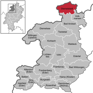
Diemelstadt is a small town in Waldeck-Frankenberg district in Hesse, Germany.

<span class="mw-page-title-main">Frankenau</span> Town in Hesse, Germany

Frankenau is a small town in Waldeck-Frankenberg district in Hesse, Germany.

<span class="mw-page-title-main">Gemünden (Wohra)</span> Town in Hesse, Germany

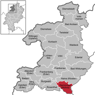
Gemünden is a town in Waldeck-Frankenberg district in Hesse, Germany.

<span class="mw-page-title-main">Allendorf (Eder)</span> Municipality in Hesse, Germany

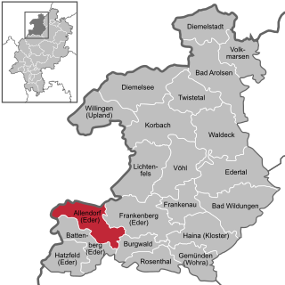
Allendorf (Eder) is a municipality which situated in the north west of Hesse, Germany. The municipality is within the Waldeck-Frankenberg district in a rural region called the upper Eder Valley. The Burgwald range is located west of Allendorf while the Breite Struth hills are in Allendorf's east.

<span class="mw-page-title-main">Volkmarsen</span> Town in Hesse, Germany

Volkmarsen[ˈfɔlkˌmaʁzn̩] is a small town in Waldeck-Frankenberg district in northern Hesse, Germany. It is home to 6840 residents.

<span class="mw-page-title-main">Burgwald</span> Municipality in Hesse, Germany

Burgwald is a municipality in Waldeck-Frankenberg in Hesse, Germany.

<span class="mw-page-title-main">Diemelsee (municipality)</span> Municipality in Hesse, Germany

Diemelsee is a municipality in Waldeck-Frankenberg in northwest Hesse, Germany, and is part of the low mountain region called Upland. Adorf is the seat of this municipality.

<span class="mw-page-title-main">Waldeck (electoral district)</span>

Waldeck is an electoral constituency represented in the Bundestag. It elects one member via first-past-the-post voting. Under the current constituency numbering system, it is designated as constituency 167. It is located in northern Hesse, comprising most of the Landkreis Kassel district and the northern part of the Waldeck-Frankenberg district.

The Eder Uplands refers to a region in North Hesse in Germany. It covers several municipalities that lies around the upper reaches of the Eder river on the edge of the Rothaar Mountains. The Eder Uplands includes a large part of the old county of Frankenberg, which was absorbed into Waldeck-Frankenberg in the wake of the administrative reforms.

References

  1. Bromskirchen wird Ortsteil von Allendorf, Hessenschau, 14 March 2021.