
Boudica or Boudicca was a queen of the ancient British Iceni tribe, who led a failed uprising against the conquering forces of the Roman Empire in AD 60 or 61. She is considered a British national heroine and a symbol of the struggle for justice and independence.

The Icknield Way is an ancient trackway in southern and eastern England that runs from Norfolk to Wiltshire. It follows the chalk escarpment that includes the Berkshire Downs and Chiltern Hills.

The A47 is a major road in England linking Birmingham to Lowestoft, Suffolk. Most of the section between Birmingham and Nuneaton is now classified as the B4114. From Peterborough eastwards, it is a trunk road.

Norfolk is a rural county in the East of England. Knowledge of prehistoric Norfolk is limited by a lack of evidence — although the earliest finds are from the end of the Lower Paleolithic period. Communities have existed in Norfolk since the last Ice Age and tools, coins and hoards such as those found at Snettisham indicate the presence of an extensive and industrious population.
Quidenham is a small rural village and civil parish in the English county of Norfolk. It covers an area of 22.51 km2 (8.69 sq mi) and had a population of 576 in 183 households at the 2001 census, falling to a population of 560 living in 189 households at the 2011 Census. For the purposes of local government, it falls within the district of Breckland.

Pulham Market is a village and civil parish in Norfolk, situated approximately 8 miles (13 km) northeast of Diss and 14 miles (23 km) south of Norwich. It covers an area of 12.08 km2 (4.66 sq mi) and had a population of 999 in 443 households as of the 2001 census, the population falling to 977 at the 2011 Census.

Long Stratton is a town and civil parish in Norfolk, England. It historically consisted of two villages; the larger, Stratton St. Mary, is to the south, and the other, Stratton St. Michael, is to the north. It had a population of 4,424 in the 2011 Census. South Norfolk Council are based in the town.
The following are lists of recreational walks in Norfolk, England.

The Angles Way is a long-distance footpath in England, close to the River Waveney and River Little Ouse and thus close to the Norfolk/Suffolk border between Great Yarmouth and Thetford.
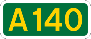
The A140 is an 'A-class' road in Norfolk and Suffolk, East Anglia, England partly following the route of the Roman Pye Road. It runs from the A14 near Needham Market to the A149 south of Cromer. It is of primary status for the entirety of its route. It is approximately 56 miles (90 km) in length.

The A149 is commonly known as "The Coast Road" to local residents and tourists, as this road runs along the North Norfolk coast from King's Lynn to Great Yarmouth, via coastal villages.

The A143 is a road that runs from the Gorleston-on-Sea area of Great Yarmouth, in Norfolk to Haverhill in Suffolk.

Stoke Holy Cross is a village in South Norfolk which lies approximately 4 miles (6.4 km) south of Norwich.

The A148 is an English A road entirely in the county of Norfolk. It runs from King's Lynn to Cromer via Fakenham, which it bypasses to the north. The road starts and ends on the A149.
The National Cycle Route 13 is a cycling route that is part of the National Cycle Network in the United Kingdom. It connects Tower Bridge in London with Fakenham in Norwich.
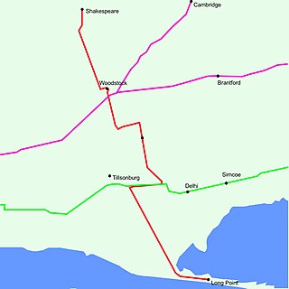
King's Highway 59, commonly referred to as Highway 59, was a provincially maintained highway in the Canadian province of Ontario. It connected Long Point Provincial Park in Norfolk County to the town of Shakespeare in Perth County, passing through the city of Woodstock in Oxford County en route. Several smaller towns also lined the highway, notably Courtland, Delhi, Norwich and Tavistock. Highway 59 featured junctions with Highway 3, Highway 2, Norfolk County Highway 24 and the concurrent routes of Highway 7 and Highway 8. Highway 59 also had an interchange with Highway 401.
This is part of a series on the History of Norfolk
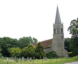
St Andrew's Church is a redundant Anglican church in the civil parish of Scole, Norfolk, England. It is recorded in the National Heritage List for England as a designated Grade I listed building, and is under the care of the Churches Conservation Trust. The church stands in an isolated position adjacent to Frenze Hall, near to the long-distance footpath, Boudica's Way, 1 mile (1.6 km) northeast of Diss.

The Boudican revolt was an armed uprising by native Celtic Britons against the Roman Empire during the Roman conquest of Britain. It took place circa AD 60–61 in the Roman province of Britain, and was led by Boudica, the Queen of the Iceni tribe. The uprising was motivated by the Romans' failure to honour an agreement they had made with Boudica's husband, Prasutagus, regarding the succession of his kingdom upon his death, and by the brutal mistreatment of Boudica and her daughters by the occupying Romans.

