Balé is one of the 45 provinces of Burkina Faso, located in its Boucle du Mouhoun Region with Boromo as capital. Its area is 4,596 km2 (1,775 sq mi), and had a population of 297,367 in 2019. The province is known for its Deux Balé Forest, populated by savannah elephant herds. Boromo, the provincial capital, is located on the main road from Ouagadougou to Bobo-Dioulasso. In June 2007, the Canadian mining company, Semafo, open the third gold mine in the country in Mana in the province, with an investment of about $116 million.
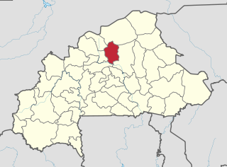
Bam is one of the 45 provinces of Burkina Faso. It is located in Centre-Nord Region and the capital of Bam is Kongoussi. In 2019 it has a population of 473,955. It is a rural province with 420,314 of its residents living in the countryside; only 53,641 live in urban areas. There are 229,786 men living in Bam Province and 244,169 women.
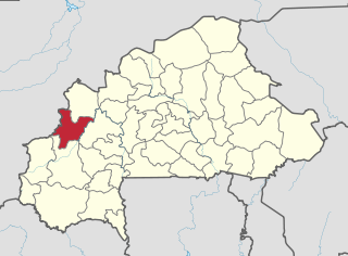
Banwa is one of the 45 provinces of Burkina Faso and is in Boucle du Mouhoun Region. The capital of Banwa is Solenzo. In 2019 it had a population of 345,749.

Bazèga is one of the 45 provinces of Burkina Faso and is in Centre-Sud Region. The capital of Bazèga is Kombissiri. Bazèga had a population of 238,202 in 2006 and in 2011 it was estimated to be 263,603.

Boulkiemdé is one of the 45 provinces of Burkina Faso and is in Centre-Ouest Region. The capital of Boulkiemdé is Koudougou. The population of Boulkiemdé was 498,008 in 2006 and 567,680 in 2011.

Comoé is one of the 45 provinces of Burkina Faso, located in its Cascades Region. The capital of Comoé is Banfora. The population of Comoé was 632,695 in 2019.

Gnagna is one of the 45 provinces of Burkina Faso, and is in Est Region. The capital of Gnagna is Bogandé. The population of Gnagna in 2019 was 675,897.

Kouritenga is one of the 45 provinces of Burkina Faso, located in its Centre-Est Region. In 2019, the province had a population of 479,930. Its capital is Koupéla.

Mouhoun is one of the 45 provinces of Burkina Faso. It is in the Boucle du Mouhoun region. The capital of Mouhoun is Dédougou.

Centre-Ouest is one of Burkina Faso's 13 administrative regions. The population of Centre-Ouest was 1,659,339 in 2019. The region's capital is Koudougou. Four provinces make up the region.

Centre-Sud is one of Burkina Faso's 13 administrative regions. The population of Centre-Sud was 638,379 in 2006 and was estimated at 722,631 in 2011. The region's capital is Manga. Three provinces – Bazèga, Nahouri, and Zoundwéogo – make up the region.

Bana is a department or commune of Balé Province in southern Burkina Faso. Its capital lies at the town of Bana. According to the 2019 census the department has a population of 19,787.
Pompoï is a department or commune of Balé Province in southern Burkina Faso. Its capital lies at the town of Pompoï. According to the 2019 census the commune has a total population of 14,067.
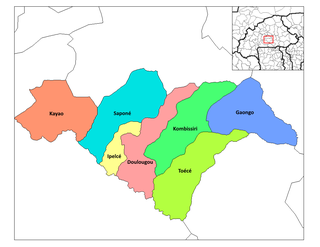
Toece is a department or commune of Bazèga Province in central Burkina Faso. Its capital lies at the town of Toece. According to the 1996 census the department has a total population of 33,608.

Bondigui is a department or commune of Bougouriba Province in south-western Burkina Faso. Its capital lies at the town of Bondigui. According to the 2006 census the department has a total population of 18,782.

Komki-Ipala is a department or commune of Kadiogo Province in central Burkina Faso. Its capital lies at the town of Komki-Ipala.

Andemtenga is a department of Kouritenga Province in eastern Burkina Faso. Its capital lies at the town of Andemtenga. It had a total population of 49,207 in 2006. Its name is sometimes shortened to Andem in colloquial usage.

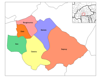
Cassou is a department or commune of Ziro Province in southern Burkina Faso. The capital is Cassou. The population of the department was 40,833 in 2006.
Kounla is a village in the Sanaba Department of Banwa Province in western Burkina Faso. As of 2005 it had a population of 452.
Iolonioro is a department or commune of Bougouriba Province in south-western Burkina Faso. Its capital lies at the town of Iiolonioro. According to the 2019 census the department has a population of 35,351.