For the town in India, see Ziro.
Bam is one of the 45 provinces of Burkina Faso. It is located in Centre-Nord Region and the capital of Bam is Kongoussi. In 2019 it has a population of 473,955. It is a rural province with 420,314 of its residents living in the countryside; only 53,641 live in urban areas. There are 229,786 men living in Bam Province and 244,169 women.
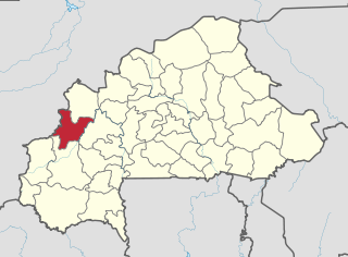
Banwa is one of the 45 provinces of Burkina Faso and is in Boucle du Mouhoun Region. The capital of Banwa is Solenzo. In 2019 it had a population of 345,749.

Bazèga is one of the 45 provinces of Burkina Faso and is in Centre-Sud Region. The capital of Bazèga is Kombissiri. Bazèga had a population of 238,202 in 2006 and in 2011 it was estimated to be 263,603.

Boulkiemdé is one of the 45 provinces of Burkina Faso and is in Centre-Ouest Region. The capital of Boulkiemdé is Koudougou. The population of Boulkiemdé was 498,008 in 2006 and 567,680 in 2011.

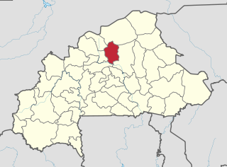
Kouritenga is one of the 45 provinces of Burkina Faso, located in its Centre-Est Region. In 2019, the province had a population of 479,930. Its capital is Koupéla.

Sanguié is one of the 45 provinces of Burkina Faso, located in its Centre-Ouest Region. In 2019 the population was 391,520. Its capital is Réo.
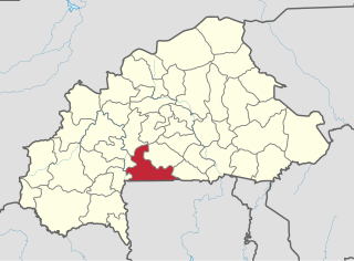
Sissili is one of the 45 provinces of Burkina Faso, located in its Centre-Ouest Region. In 2006 the population was 212,628 and in 2011 the population was 240,830, an increase of 13.3%.

Centre is one of Burkina Faso's 13 administrative regions. The population of Centre Province was 1,727,390 at the 2006 census and increased by 75.6% in 13 years to 3,030,384 at the 2019 census, of which 50.8% was female. It is the most populous and urbanised region in Burkina Faso; in 2019 14.8% of Burkina Faso's population lived in Centre. The region's capital is Ouagadougou, which also serves as the national capital. Centre region consists of only one province, Kadiogo.

Centre-Ouest is one of Burkina Faso's 13 administrative regions. The population of Centre-Ouest was 1,659,339 in 2019. The region's capital is Koudougou. Four provinces make up the region.

Centre-Sud is one of Burkina Faso's 13 administrative regions. The population of Centre-Sud was 638,379 in 2006 and was estimated at 722,631 in 2011. The region's capital is Manga. Three provinces – Bazèga, Nahouri, and Zoundwéogo – make up the region.
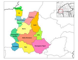
Satiri is a department or commune of Houet Province in south-western Burkina Faso. Its capital lies at the town of Satiri.

Andemtenga is a department of Kouritenga Province in eastern Burkina Faso. Its capital lies at the town of Andemtenga. It had a total population of 49,207 in 2006. Its name is sometimes shortened to Andem in colloquial usage.
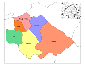
Dalo Department is a department or commune of Ziro Province in southern Burkina Faso. The administrative seat is the village of Dalo. The population of the department was 10,746 in 2006.
Ouenga, sometimes spelt Oueenga, Winga or Wenga, is a commune in the Andemtenga Department of Kouritenga Province in the Centre-Est region of Burkina Faso. It had a population of 5,241 in 2006.
Sabrabinatenga, also spelt Sabrabintenga, is a commune in the Andemtenga Department of Kouritenga Province in the Centre-Est region of Burkina Faso. It had a population of 2,034 in 2006.
Neneogo is a commune in the Dialgaye Department of Kouritenga Province in the Centre-Est region of Burkina Faso. It had a population of 2,194 in 2006.
Ténoaghin, also spelt Tenoaghin or Tenoinghin, is a commune in the Dialgaye Department of Kouritenga Province in the Centre-Est region of Burkina Faso. It had a population of 1,297 in 2006.
Belembaoghin, also spelt Belembaghin, Belmbaghin or Bélembaoguen, is a commune in the Gounghin Department of Kouritenga Province in the Centre-Est region of Burkina Faso. It had a population of 522 in 2006.
Belemboulghin, also spelt Belemboulgui, is a commune in the Gounghin Department of Kouritenga Province in the Centre-Est region of Burkina Faso. It had a population of 1,350 in 2006.