Related Research Articles
The Pike's Peak Gold Rush was the boom in gold prospecting and mining in the Pike's Peak Country of western Kansas Territory and southwestern Nebraska Territory of the United States that began in July 1858 and lasted until roughly the creation of the Colorado Territory on February 28, 1861. An estimated 100,000 gold seekers took part in one of the greatest gold rushes in North American history.
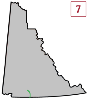
The Atlin Road is a road in British Columbia and Yukon, Canada. It is designated as Highway 7 in Yukon, and has no official highway number in British Columbia.

The Stikine Country, also referred to as the Stikine District or simply "the Stikine", is one of the historical geographic regions of the Canadian province of British Columbia, located inland from the central Alaska Panhandle and comprising the basin of the Stikine River and its tributaries. The term Stikine–Iskut is also fairly common to describe the area, and references the Iskut River, the Stikine's largest tributary and describable as its south fork.
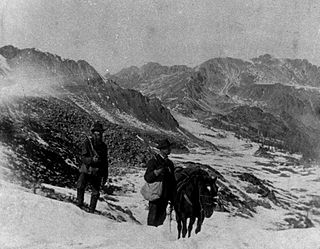
The Atlin District, also known as the Atlin Country, is a historical region located in the far northwestern corner of the Canadian province of British Columbia, centred on Atlin Lake and the gold-rush capital of the region, the town of Atlin. The term "Atlin District" was also used synonymously with the official administrative area named the Atlin Mining District, established during the gold-mining heyday contemporaneous with the Klondike Gold Rush. The region also includes adjoining Teslin and Tagish Lakes and the Bennett Lake area in the narrow strip of BC separating the Alaska Panhandle from the Yukon. The Atlin District is currently part of the Stikine Region in the regional district system. The communities of the Atlin lakes district, as the area is casually called, are referred to in national weather reports as "the Southern Lakes", as in "Whitehorse and the Southern Lakes", although this also includes towns on the Yukon end of the lakes.

Bummerville is an unincorporated community in Calaveras County, California, about 1 mile east of West Point. It has frequently been noted on lists of unusual place names. It lies at an elevation of 898 m (2946 ft) and is located at 38°24′05″N120°30′21″W.
The Taku River Tlingit First Nation are the band government of the Inland Tlingit in far northern British Columbia, Canada and also in Yukon. They comprise two ḵwaan (tribes) of the Tlingit people, who are otherwise coastal, the Áa Tlein Ḵwáan of the Atlin Lake area and the Deisleen Ḵwáan of Teslin Lake, whose main focus is the Teslin Tlingit Council in Teslin, Yukon. Their band offices are in Atlin, British Columbia.

Gold Rush is a reality television series that airs on Discovery and its affiliates worldwide. The series follows the placer gold mining efforts of various family-run mining companies, mostly in the Klondike region of Dawson City, Yukon, Canada. In its 11th season as of early 2020, prior seasons also included mining efforts in South America and western North America.
Birch Creek is a creek located in the Atlin Country region of British Columbia. Birch Creek flows parallel to Boulder Creek and Ruby Creek. The creek is located west of Lake Surprise. Birch Creek flows into Pine Creek and was discovered in 1898. The greatest mining activity took place between 1902 and the start of the First World War. Some mining activity also occurred during the 1930s. The Dominion Trust Company hydraulicked Birch Creek in the 1930s. The largest pure gold nugget in the district was recovered from this creek in 1913. The nugget was 73 ounces. In the Gold Boom years the Creek was largely ignored as the depth of bed rock discouraged hand mining operations. When gold in other creeks in the vicinity were exhausted, attention was turned to Birch.

Discovery City is a ghost town located in the Atlin Country region of British Columbia. The city was located near Pine Creek, southwest of the south end of Surprise Lake. Discovery City was also known as Pine City. Discovery City existed to support the gold mining operations in the area. The city was founded in 1898 with the discovery of gold in Pine Creek. For a few years it had a population of 1,000. The city had hotels such as the Pine Tree, The Nugget, The Gold House and others. When the gold was depleted, the city was vacated. By 1915 it was deserted.
Surprise City is a ghost town located in the Atlin Country Region of British Columbia. Surprise City is located on Otter Creek near the southwest end of Surprise Lake. Surprise City is also known as Otter Creek. The city existed to support the gold mining operations in the area.
McKee Creek is a creek located in the Atlin Country region of British Columbia. The creek flows into Atlin Lake from the east side. It is located 8 miles south of Atlin Town and is 7 miles in length. McKee Creek was first discovered in 1898, and since then has been hand-mined and hydraulicked. Outfits such as Atlin Mining Company have worked the creek, with the largest gold nugget recovered from the creek weighing just over 28 ounces. McKee Creek was a consistent mining producer well into the 1930s.
O'Donnel River is a river located in the Atlin Country region of British Columbia. This river flows into the east side of Atlin Lake about 23 kilometres (14 mi) south of the town of Atlin. The river is about 48 kilometres (30 mi) long. The river was first recorded in 1898 and was originally known as Moose River or Caribou River. In 1912 a rich gold streak was discovered in the river, which attracted many miners. The river has been sluiced, drifted, and hydraulicked.
Otter Creek is a creek located in the Atlin Country region of British Columbia. This creek flows into the south side of Lake Surprise about 2 miles west of Wright Creek. Otter Creek was discovered in 1898. The creek has been mined and for some years Compagnie Francaise des Mines d'Or du Canada hydraulicked a number of leases along Otter Creek.
Pine Creek is a creek located in the Atlin Country region of British Columbia. Pine Creek flows out of Lake Surprise and empties into Atlin Lake just south of the town of Atlin. The creek is 12 miles in length. The gold bearing section is 2 miles long. This creek was staked in 1898 by Fritz Miller and Kenneth McLaren. By 1899, 3,000 prospectors stood on the banks of this creek. The largest nugget found weighed just over 48 ounces and was discovered in 1925. The creek has been worked with rockers, waterwheels, sluices and hydraulicked.
Ruby Creek is a creek located in the Atlin Country region of British Columbia. This creek flows into the north side of Lake Surprise about 3 miles to the east of Boulder Creek. The creek has been mined and was discovered in 1898. The largest nugget recovered from the creek weighed just over 47 ounces on July 3, 1931.
Spruce Creek is located in the Atlin Country region of British Columbia. The creek flows into Pine Creek. Fred Marius discovered gold in this creek in 1898. In 1899 two American prospectors named West and Hoffenen found a gold nugget which weighed just over 83 ounces. The nugget was nicknamed "the west". "The west" nugget contained some quartz and thus was not the largest solid gold nugget found in British Columbia. The creek produced over 300,000 fine ounces of gold, valued at $7,000,000.
Dollis Creek is a creek that spans the border between British Columbia and the Yukon. The creek is 8 miles in length and flows from the Atlin Country region of British Columbia north across the BC-Yukon boundary into the Tatshenshini River approximately 10 miles from Old Dalton Post.
Wright Creek is a creek located in the Atlin Country region of British Columbia. The creek flows into the south side of Lake Surprise. It is located 2 miles to east of Otter Creek. The creek was mined for gold.
The Atlin River is a river located in the Atlin/Téix'gi Aan Tlein Provincial Park in British Columbia, Canada. It flows out from Atlin Lake
Latta Creek is a tributary stream of Salado Creek in the Diablo Range in Stanislaus County, California. It has its source at 37°24′05″N121°19′33″W. Its mouth is at its confluence with Salado Creek. The creek is named for Eli C. Latta, a pioneer that came to California during the California Gold Rush and homesteaded the headwaters of the creek.
References
- ↑ N.L. Barlee (1980), The Guide to Gold Panning, Revised Second Edition, Second Printing. Canada West Publications., ISBN 0-920164-04-8