Bluie was the United States military code name for Greenland during World War II. It is remembered by the numbered sequence of base locations identified by the 1941 United States Coast Guard South Greenland Survey Expedition, and subsequently used in radio communications by airmen unfamiliar with pronunciation of the Inuit and Old Norse names of those locations. These were typically spoken BLUIE (direction) (number), with direction being east or west along the Greenland coast from Cape Farewell.
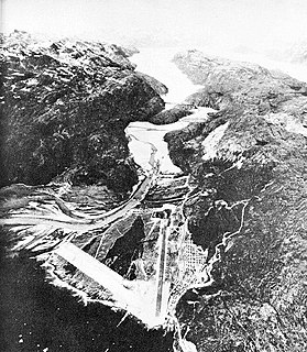
Anemometer Hill is a hill 25 metres (80 ft) high northeast of Fishtrap Cove on Stonington Island, in Marguerite Bay, Antarctica. It was surveyed by the East Base party of the U.S. Antarctic Service, 1939–41, which built its base on this island, and so named by the United Kingdom Antarctic Place-Names Committee because the hill was the site of an anemometer in 1961.

Caulfeild Glacier is the northern of two glaciers flowing into Hugi Glacier west of Dodunekov Peak, on the west coast of Graham Land. It was photographed by Hunting Aerosurveys Ltd in 1955–57 and mapped from these photos by the Falkland Islands Dependencies Survey. It was named by the UK Antarctic Place-Names Committee in 1959 for Vivian Caulfeild (1874–1958), English pioneer ski instructor, one of the greatest authorities on technique.

Chinstrap Cove is a cove 6 km (3.7 mi) north-east of Escarpada Point on the north-west coast of Clarence Island, South Shetland Islands, Antarctica entered northeast of Vaglen Point. The cove has been identified as an Important Bird Area (IBA) by BirdLife International because it supports a large breeding colony of about 20,000 pairs of chinstrap penguins, after which it was named by the UK Joint Services Expedition which visited the site in 1970-1971. The 74 ha IBA includes the ice-free area south of the cove, extending 2 km along the coast.
Norseman Point is an easternmost point of Neny Island, lying in Marguerite Bay off the west coast of Graham Land. First surveyed in 1936 by the British Graham Land Expedition (BGLE) under Rymill. Named by the Falkland Islands Dependencies Survey (FIDS) after the Norseman airplane which landed near the point to relieve the FIDS party on Stonington Island in February 1950.
Earnshaw Glacier is a glacier 10 nautical miles (19 km) long, flowing northward to the east of Norwood Scarp and entering Maitland Glacier to the south of Werner Peak, in the eastern Antarctic Peninsula. It was photographed from the air by the United States Antarctic Service on September 28, 1940. It was surveyed by the Falkland Islands Dependencies Survey in January 1961, and was named by the UK Antarctic Place-Names Committee after Thomas Earnshaw, an English watchmaker who made innovations leading to the modern marine chronometer.
Fishtrap Cove is a small cove 0.1 nautical miles (0.2 km) northwest of Boulder Point on the southwest side of Stonington Island, close off the west coast of Graham Land, Antarctica. It was first surveyed by the United States Antarctic Service, 1939–41, and resurveyed in 1946–47 by the Falkland Islands Dependencies Survey (FIDS), who so named it because FIDS parties used this cove for setting fish traps.
Flagpole Point is a point 0.2 nautical miles (0.4 km) northwest of Fishtrap Cove, forming the southern part of the western extremity of Stonington Island, close off the west coast of Graham Land, Antarctica. It was first surveyed by the United States Antarctic Service (USAS), 1939–41, whose East Base was located on this island. It was resurveyed in 1946–47 by the Falkland Islands Dependencies Survey, and so named by them because of the flagpole which was erected by the USAS on a rocky knoll close northeast of this point.
Fricker Glacier is a glacier, 10 nautical miles (19 km) long, which lies close north of Monnier Point and flows in a northeasterly direction into the southwest side of Mill Inlet, on the east coast of Graham Land, Antarctica. It was charted by the Falkland Islands Dependencies Survey (FIDS) and photographed from the air by the Ronne Antarctic Research Expedition in 1947, and was named by the FIDS for Karl Fricker, a German Antarctic historian.
The Harvey Shoals are three shoal patches with least depths of 3 fathoms (5.5 m), located between Miller Island and Northstar Island in Marguerite Bay, Antarctica. They were charted by the Hydrographic Survey Unit from RRS John Biscoe in 1966, and were named for Petty Officer Brian E. Harvey, the surveying recorder who carried out all the sounding for this survey.
Haulaway Point is a small rocky point midway along the northeast side of Stonington Island, close off the west coast of Graham Land, Antarctica. It was first surveyed by the United States Antarctic Service, 1939–41. It was resurveyed in 1946–47 by the Falkland Islands Dependencies Survey, who so named the point because it is one of the best places for hauling stores ashore.
Hunt Peak is a triangular rock peak, 610 metres (2,000 ft) high, marking the north side of the entrance to Stonehouse Bay on the east coast of Adelaide Island, Antarctica. It was discovered and first roughly surveyed in 1909 by the French Antarctic Expedition under Jean-Baptiste Charcot. It was resurveyed in 1948 by the Falkland Islands Dependencies Survey (FIDS), who named the point marked by this peak for Sergeant Kenneth D. Hunt, a mechanic for the expedition's Noorduyn Norseman airplane in 1950. Further survey in 1957–58 by the FIDS showed no definable point in the vicinity and the name was transferred to the peak.
McClary Glacier is a glacier 10 nautical miles (19 km) long and 2 nautical miles (4 km) wide on the west coast of Graham Land, Antarctica. It flows southwest along the north side of Butson Ridge into Marguerite Bay between Cape Calmette and the Debenham Islands. The glacier was first roughly surveyed by the British Graham Land Expedition, 1936–37, and resurveyed by the Falkland Islands Dependencies Survey, 1946–50. It was named by the UK Antarctic Place-Names Committee for George B. McClary, father of Nelson McClary, mate on the Port of Beaumont during the Ronne Antarctic Research Expedition, 1947–48.
Saussure Glacier is a glacier flowing northeast from Tyndall Mountains, Arrowsmith Peninsula, into Lallemand Fjord, Loubet Coast. Photographed from the air by Falkland Islands and Dependencies Aerial Survey Expedition (FIDASE) in 1957. Named by the United Kingdom Antarctic Place-Names Committee (UK-APC) in association with the names of glaciologists grouped in the area after Horace-Bénédict de Saussure (1740–99), Swiss naturalist and physicist, who in 1787 was the first to recognize that erratic boulders had been moved great distances by ice.
Skinner Glacier is a glacier on the west edge of Palmer Land, flowing south-southwest between Mount Dixey and Mount Flower to enter George VI Sound just east of Carse Point. Named by United Kingdom Antarctic Place-Names Committee (UK-APC) after Alexander C. Skinner, British Antarctic Survey (BAS) geologist at Fossil Bluff and Stonington Island stations, 1968-70.
Hooke Point is a point near the head of Lallemand Fjord, in Graham Land, Antarctica. It was mapped by the Falkland Islands Dependencies Survey from surveys and air photos, 1946–59, and was named by the UK Antarctic Place-Names Committee for Robert Hooke, an English experimental physicist and author of Micrographia, which contains one of the earliest known descriptions of ice crystals.
Relay Hills is a group of low, ice-covered hills, mainly conical in shape, between Mount Edgell and Kinnear Mountains in western Antarctic Peninsula. First roughly surveyed from the ground by British Graham Land Expedition (BGLE), 1936-37. Photographed from the air by Ronne Antarctic Research Expedition (RARE), November 1947. Resurveyed by Falkland Islands Dependencies Survey (FIDS), November 1958. The name, applied by the United Kingdom Antarctic Place-Names Committee (UK-APC), arose because both the BGLE and the FIDS sledging parties had to relay their loads through this area to the head of Prospect Glacier.
Reptile Ridge is a ridge over 2 nautical miles (3.7 km) long, rising to about 250 m and extending northwest from the vicinity of Rothera Point, Adelaide Island. The name is descriptive of its appearance when viewed in profile from north or south. Named by the United Kingdom Antarctic Place-Names Committee (UK-APC) in 1977.
Back Bay is a bay 1 km (0.6 mi) wide along the west coast of Graham Land, Antarctica. Its entrance lies between Stonington Island and Fitzroy Island, with the head of the bay formed by Northeast Glacier. The bay was first surveyed by the US Antarctic Service, 1939–41, and so named by them because of its location at the rear (north-east) side of Stonington Island.


