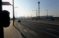
The Boulevard Périphérique, often called the Périph, is a limited-access dual-carriageway ring road in Paris, France. With a few exceptions, it is situated along Paris's administrative limit.

Michel Bizot is a station on line 8 of the Paris Métro in the 12th arrondissement. It is named after the nearby avenue du Général-Michel-Bizot, which is in turn named after the French military engineer General Michel Brice Bizot (1795–1855), fatally shot at the siege of Sevastopol during the Crimean War.

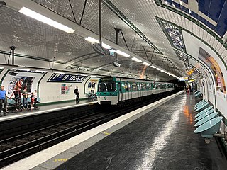
Porte Dorée is a station on line 8 of the Paris Métro in the 12th arrondissement.

Porte de Charenton is a station on Line 8 of the Paris Métro located in the 12th arrondissement of Paris.
Porte de Saint-Ouen is a station on line 13 of the Paris Métro on the border of the 17th and 18th arrondissements. Unusually it has an escalator directly linking the platform to the street at the exit to the Rue Leibniz.

Paris Métro Line 8 is one of the sixteen lines of the Paris Métro. It connects Balard in the southwestern part of Paris to Pointe du Lac station in the southeastern suburbs, following a parabolic route on the Rive Droite of the Seine. The last line of the original 1898 Paris Métro plan, which opened in July 1913, it was initially intended to link Porte d'Auteuil and Opéra. With 105.5 million travellers in 2017, it is the network's eighth busiest line; at 23.4 km (14.5 mi) in length, it is also the second longest Métro Line after Line 13, and the longest fully straight line, as line 13 has branches. Along with Line 7, it serves the most stations of any line on the network, at 38. Line 8 interchanges with all but three other Métro lines.

Paris's former Chemin de fer de Petite Ceinture, also colloquially known as La Petite Ceinture, was a circular railway built as a means to supply the city's fortification walls, and as a means of transporting merchandise and passengers between Paris' major rail-company stations. Beginning as two distinct 'Ceinture Syndicate' freight and 'Paris-Auteuil' passenger lines from 1851, these lines formed an arc that surrounded the northern two thirds of Paris, an arc that would become a full circle of rail around the capital when its third Ceinture Rive Gauche section was built in 1867.

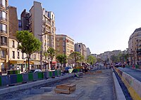
Île-de-France tramway lines 3a and 3b are the first modern tramway in Paris proper since the 1937 closure of the previous comparable system. They are operated by the RATP and divided into two sections called T3a and T3b. The line is also known as the Tramway des Maréchaux because it follows the Boulevards of the Marshals, a series of boulevards that encircle Paris along the route of the former Thiers Wall. The boulevards are, with three exceptions, named for Napoleon's First Empire marshals (maréchaux); they were transformed by redevelopment works carried out during the two-and-a-half-year construction of the line, which opened on 16 December 2006 under the designation T3.

The pont National is a road and rail bridge across the Seine in Paris, to the east of the 12th and 13th arrondissements. With a total length of 188.5 metres (618 ft), it is made up of 5 masonry arches. Its rail part carries the Petite Ceinture, now disused, and its road part links boulevard Poniatowski to boulevard Masséna. Its nearest Paris Métro stations are Porte de Charenton and Cour Saint-Émilion.

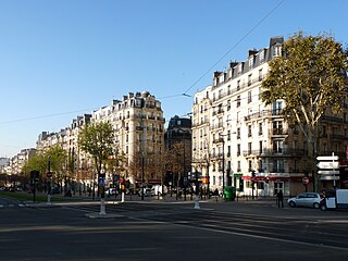
The Boulevards of the Marshals are a collection of thoroughfares that encircle the city of Paris, France, just inside its city limits. Most bear the name of a marshal of the First French Empire (1804–1814) who served under Napoleon I. The Île-de-France tramway Lines 3a and 3b today run on the Boulevards of the Marshals.
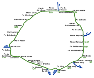
While Paris is encircled by the Boulevard Périphérique, the city gates of Paris are the access points to the city for pedestrians and other road users. As Paris has had successive ring roads through the centuries, city gates are found inside the modern-day Paris.

The city walls of Paris refers to the city walls that surrounded Paris, as it grew from ancient times until the 20th century, built primarily to defend the city but also for administrative reasons. Several successive city walls were built over the centuries, either adding to existing walls or replacing demolished ones, through 1846, when construction of the Thiers wall was completed.

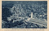
The Thiers wall was the last of the defensive walls of Paris. It was an enclosure constructed between 1841 and 1846 and was proposed by the French prime minister Adolphe Thiers but was actually implemented by his successor. The 33 kilometres (21 mi) long wall and ditch made a complete circuit around the city as it stood at the time of the July Monarchy. It was bombarded by the Prussian Army during the Franco-Prussian War, captured by government troops during the Paris Commune and refortified at the start of the First World War. However, by then it had become obsolete as a fortification and was a barrier to the expansion of the city. The area immediately outside of it, known as "the zone", had become a shanty town. The wall was demolished in the interwar period; its path today can be traced by the Boulevards of the Marshals which originally ran just behind the fortifications and by the Boulevard Périphérique which was later built just outside. A few remnants of the wall can still be seen.

The Porte de Vincennes is one of the city gates of Paris (France) situated in the Bel Air neighborhood of the 12th arrondissement.

The Boulevard de l'Amiral-Bruix is a boulevard in the 16th arrondissement of Paris, France. It is one of the Boulevards of the Marshals that circle the outer parts of the city.

The Porte d'Italie is one of the city gates of Paris, located in the 13th arrondissement, at the intersection of the Avenue d'Italie, the Boulevard Massena, the Avenue de la Porte d'Italie and the Rue Kellermann, facing Le Kremlin-Bicêtre.

The Boulevard Mortier is a boulevard in the 20th arrondissement of Paris, France. It is one of the Boulevards of the Marshals, which circle the outer parts of the city.
The Boulevard Lefebvre is a boulevard in the Saint-Lambert quarter in the 15th arrondissement of Paris, France. It is one of the Boulevards of the Marshals, which run in the outer parts of the city.

The Boulevard Soult is a boulevard in the Bel-Air neighborhood in the 12th arrondissement of Paris, France. It is one of the Boulevards of the Marshals that run in the outer parts of the city.