The Boulevard Périphérique, often called the Périph, is a limited-access dual-carriageway ring road in Paris, France. With a few exceptions, it is situated along Paris's administrative limit.

Montreuil, also known unofficially as Montreuil-sous-Bois, is a commune in the eastern suburbs of Paris, France. It is located 6.6 km (4.1 mi) from the centre of Paris, in the Seine-Saint-Denis department and in the Métropole du Grand Paris. With a population of 111,367 as of 2020, Montreuil is the third most populous suburb of Paris after Boulogne-Billancourt and Saint-Denis. It is located north of Paris's Bois de Vincennes, on the border with Val-de-Marne.

Porte d'Italie is a station on Line 7 of the Paris Métro, and a stop on tramway T3a in the 13th arrondissement. It is named after the Porte d'Italie, a gate in the 19th century Thiers wall of Paris, which led to the south and Italy.
Porte de Choisy is a station on line 7 of the Paris Métro, a stop on tramway T3a as well as the northern terminus of tramway T9 in the 13th arrondissement. It is named after the Porte de Choisy, a gate in the nineteenth century Thiers wall of Paris, which led to Choisy-le-Roi.

Porte Dorée is a station on line 8 of the Paris Métro in the 12th arrondissement.

Porte de Charenton is a station on Line 8 of the Paris Métro located in the 12th arrondissement of Paris.

Porte de Versailles is a station on line 12 of the Paris Métro, a stop on tramway T3a as well as the southern terminus of tramway T2 in the 15th arrondissement. It is named after the Porte de Versailles, a gate in the 19th century Thiers wall of Paris, which led to the city of Versailles.

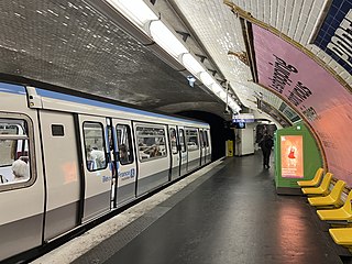
Paris Métro Line 8 is one of the sixteen lines of the Paris Métro. It connects Balard in the southwestern part of Paris to Pointe du Lac station in the southeastern suburbs, following a parabolic route on the Rive Droite of the Seine. The last line of the original 1898 Paris Métro plan, which opened in July 1913, it was initially intended to link Porte d'Auteuil and Opéra. With 105.5 million travellers in 2017, it is the network's eighth busiest line; at 23.4 km (14.5 mi) in length, it is also the second longest Métro Line after Line 13, and the longest fully straight line, as line 13 has branches. Along with Line 7, it serves the most stations of any line on the network, at 38. Line 8 interchanges with all but three other Métro lines.
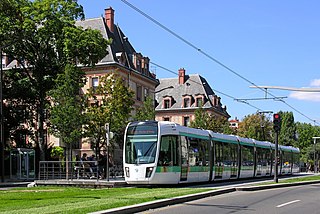
The Île-de-France tramways is a network of modern tram lines in the Île-de-France region of France. Fourteen lines are currently operational, with extensions and additional lines in both construction and planning stages. Although the system mainly runs in the suburban regions of Paris, lines T3a and T3b run entirely within Paris city limits, while lines T2 and T9 start their routes within Paris' borders. While lines operate independently of each other and are generally unconnected, some connections do exist: between lines T2 and T3a, T3a and T3b, T1 and T5, T1 and T8, T8 and T11 Express, T3a and T9 and T6 and T10. However, the final design of the entire planned tram network is fairly integrated.

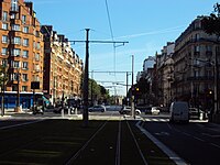
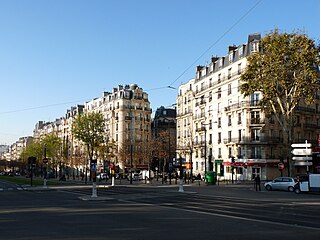
Île-de-France tramway lines 3a and 3b are the first modern tramway in Paris proper since the 1937 closure of the previous comparable system. They are operated by the RATP and divided into two sections called T3a and T3b. The line is also known as the Tramway des Maréchaux because it follows the Boulevards of the Marshals, a series of boulevards that encircle Paris along the route of the former Thiers Wall. The boulevards are, with three exceptions, named for Napoleon's First Empire marshals (maréchaux); they were transformed by redevelopment works carried out during the two-and-a-half-year construction of the line, which opened on 16 December 2006 under the designation T3.
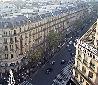
The Boulevards of Paris are boulevards which form an important part of the urban landscape of Paris. The boulevards were constructed in several phases by central government initiative as infrastructure improvements, but are very much associated with strolling and leisurely enjoyment in the minds of Parisians.

The Boulevards of the Marshals are a collection of thoroughfares that encircle the city of Paris, France, just inside its city limits. Most bear the name of a marshal of the First French Empire (1804–1814) who served under Napoleon I. The Île-de-France tramway Lines 3a and 3b today run on the Boulevards of the Marshals.
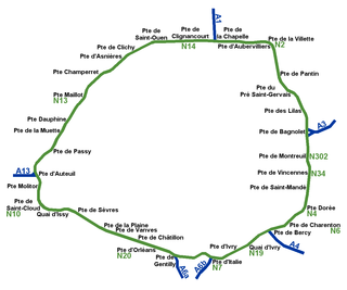
While Paris is encircled by the Boulevard Périphérique, the city gates of Paris are the access points to the city for pedestrians and other road users. As Paris has had successive ring roads through the centuries, city gates are found inside the modern-day Paris.

Porte de Clichy station is a station on Line 13 and Line 14 of the Paris Métro and RER C, as well as a stop on Île-de-France tramway Line 3b. Located in the 17th arrondissement, the Métro station is situated on the northwestern branch of Line 13, under the Avenue de Clichy. It serves the Tribunal de grande instance de Paris. The station is named after the Porte de Clichy, a gate in the nineteenth century Thiers wall of Paris, which led to Clichy.

The Porte de Vincennes is one of the city gates of Paris (France) situated in the Bel Air neighborhood of the 12th arrondissement.

The Boulevard de l'Amiral-Bruix is a boulevard in the 16th arrondissement of Paris, France. It is one of the Boulevards of the Marshals that circle the outer parts of the city.

The lycée Paul-Valéry, commonly known as PV, is a public general and technological school in the 12th arrondissement of Paris located at 38, boulevard Soult. It is a lycée specialising in science, economics, literature and arts, particularly known for its courses in cinema and audiovisual, which were the first created in France, in 1983.

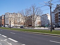
The Boulevard Poniatowski is a boulevard in the Bel-Air, Picpus and Bercy neighborhoods in the 12th arrondissement of Paris, France. It is one of the Boulevards of the Marshals that run in the outer parts of the city.

The Boulevard Mortier is a boulevard in the 20th arrondissement of Paris, France. It is one of the Boulevards of the Marshals, which circle the outer parts of the city.
The Boulevard Lefebvre is a boulevard in the Saint-Lambert quarter in the 15th arrondissement of Paris, France. It is one of the Boulevards of the Marshals, which run in the outer parts of the city.