Bovlstrup

Last updated
Bovlstrup
Village
BoulstrupStationVejside.jpg
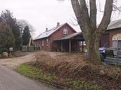
The former Bovlstrup Station
Denmark Central Jutland location map.svg
Red pog.svg
Bovlstrup
Location in the Central Denmark Region
Coordinates: 55°56′30″N10°12′58″E / 55.94167°N 10.21611°E / 55.94167; 10.21611
Country Denmark
Region Central Denmark
Municipality Odder
Population
 (2023) [1]
298
Time zone UTC+1 (CET)
  Summer (DST) UTC+2 (CEST)

Bovlstrup or Boulstrup is a village in Jutland, Denmark. It is located in Odder Municipality of the Central Denmark Region, near the Bay of Aarhus.

History

Early in its history, Borvlstrup contained a warehouse and a customs post.

Bovlstrup Station opened near the village in 1884, as a stop on the Hads-Ning Hundreds' Railroad, connecting Bovlstrup to Hou, Odder and Aarhus. [2] [3] When the Hou-Odder stretch was shut down in 1977, the station in Bovlstrup was shut down as well. [3]

Related Research Articles

<span class="mw-page-title-main">Aarhus</span> City in Central Denmark Region, Denmark

Aarhus is the second-largest city in Denmark and the seat of Aarhus Municipality. It is located on the eastern shore of Jutland in the Kattegat sea and approximately 187 kilometres (116 mi) northwest of Copenhagen.

<span class="mw-page-title-main">Odder</span> Place in Central Denmark, Denmark

Odder is a town in Jutland, Denmark. The town is the seat of Odder municipality, and is the biggest town in the municipality. It is located 20 km south of Aarhus and 16 km south-east of Skanderborg.

<span class="mw-page-title-main">Skanderborg</span> Town in Mid Jutland, Denmark

Skanderborg is a town in Skanderborg municipality, Denmark. It is situated on the north and north eastern brinks of Skanderborg Lake and there are several smaller ponds and bodies of water within the city itself, like Lillesø, Sortesø, Døj Sø and the swampy boglands of Eskebæk Mose. Just north of the town on the other side of Expressway E45, is the archaeologically important Illerup Ådal. Over time, the town has grown into a suburb of Aarhus to the north east, connected by the urban areas of Stilling, Hørning and Hasselager.

<span class="mw-page-title-main">Skejby</span> Neighborhood in Aarhus Municipality, Central Denmark Region, Kingdom of Denmark

Skejby is a neighbourhood and former village in Aarhus, Denmark. The neighbourhood is part of the city district Aarhus N.

<span class="mw-page-title-main">Tunø</span> Danish island in the Kattegat

Tunø is a Danish island in the Kattegat, approximately 4 km west of the neighbouring island of Samsø. The island covers an area of 3.52 square kilometres, has a circumference of 9.5 km (5.9 mi) and has total of 66 inhabitants as of November 2022. It comes under the administration of Odder municipality. Tunø By is the only village on the island, with the hamlet of Løkkegårde as the second most populated area.

<span class="mw-page-title-main">Aarhus Municipality</span> Municipalities of Denmark in Central Denmark

Aarhus Municipality, known as Århus Municipality until 2011, is a municipality in Central Denmark Region, on the east coast of the Jutland peninsula in central Denmark.

<span class="mw-page-title-main">Odder Municipality</span> Municipality in Central Denmark, Denmark

Odder Municipality is a municipality in the Central Denmark Region on the east coast of the Jutland peninsula in Central Denmark south of Aarhus. It is a part of the greater Aarhus area. The municipality covers an area of 225.04 km², including the islands of Alrø and Tunø. It borders Aarhus Municipality to the north, Skanderborg Municipality to the north-west and Horsens Municipality to the west. It also connects to Hedensted Municipality across Horsens Fjord to the south, and connects to Samsø Municipality through a ferry route.

<span class="mw-page-title-main">Lystrup</span> Town in Region Midtjylland, Denmark

Lystrup is a suburb to Aarhus, Denmark. It is located 10 km north of Aarhus city centre, west of Egå and the Bay of Aarhus. It had a population of 10,213, and is the second most populous urban area of Aarhus Municipality.

<span class="mw-page-title-main">Malling, Denmark</span> Village in Midtjylland, Denmark

Malling is a village in Denmark, located about 12 km (7.5 mi) south of Aarhus. It has a population of 6,194 (Jan 1, 2020).

<span class="mw-page-title-main">East Jutland metropolitan area</span> Place

East Jutland metropolitan area is a potential metropolitan area in Jutland and Funen, Denmark. Aarhus is the most populated city in the region.

<span class="mw-page-title-main">Mårslet</span> Town in Midtjylland, Denmark

Mårslet is a railway town in Denmark, located about 11 km (6.8 mi) south of Aarhus. It has a population of 5,162. Mårslet is located in Aarhus Municipality and therefore is part of the Central Denmark Region.

<span class="mw-page-title-main">Aarhus Central Station</span> Railway station in Aarhus, Denmark

Aarhus Central Station is the main railway station serving the city of Aarhus, Denmark. Serving as the main connecting hub for rail traffic between Aarhus and the rest of Denmark, the station is used by an average of 6.3 million people per year, making it the busiest station in Denmark outside the Copenhagen area. It is located in the city centre between the districts of Midtbyen and Frederiksbjerg with entrances from Banegårdspladsen and the shopping centre Bruun's Galleri, and with access to platforms from M.P. Bruuns Gade.

<span class="mw-page-title-main">Aarhus N</span> Postal district in Aarhus

Aarhus N is a postal district in the city of Aarhus, consisting of Trøjborg, Risskov, Vejlby, Skejby, Vorrevangen and Christiansbjerg, all with postal code 8200. Aarhus N is an abbreviation for Aarhus Nord and is located north of the city centre. It is the highest lying area of Aarhus.

<span class="mw-page-title-main">Aarhus Letbane</span> Light rail line serving Aarhus, Denmark

The Aarhus Letbane is a light rail system in the city of Aarhus, Denmark. It is operated by the company Midttrafik. The first line opened in December 2017, but the system is under continuous development and expansion. Service on the intercity section Odder to Lisbjergskolen opened on August 25, 2018. A third intercity line to Grenå opened on 30 April 2019. More lines are being planned.

<span class="mw-page-title-main">Godsbanen</span>

Godsbanen is a cultural centre in central Aarhus, Denmark since 2012. The site and most of the buildings are a former goods station, known as "Aarhus Godsbanegård", which was in use from 1923 to 2000. It is located at the end of a broad sidetrack to the central railway yard of Aarhus. In December 2010, Realdania announced that the area would be gradually transformed into a modern city district, through a collaborative project with Aarhus Municipality. Apart from the new cultural centre of Godsbanen, there are plans to build several buildings and institutions along the former railway yard, including a new school of architecture.

<span class="mw-page-title-main">Aarhus Commuter Rail</span>

Aarhus Commuter Rail was a commuter rail service in and near Aarhus, Denmark.

<span class="mw-page-title-main">Nørre Stenbro</span> Neighborhood in Aarhus Municipality, Central Denmark Region, Kingdom of Denmark

Nørre Stenbro is a small neighborhood in the city of Aarhus, Denmark home to some 3,000 residents. The neighborhood is part of the Aarhus C district and borders the neighborhoods of Indre By south and west, Aarhus Docklands in the east and Trøjborg north. The residential area of Nørre Stenbro is delimited by the streets Nørre Boulevard, Østboulevarden, Østbanetorvet, Kystvejen, Nørreport and Nørrebrogade, but the large Nordre Cemetery and the smaller residential quarter of Skovvejskvarteret is also part of the same registration.

<span class="mw-page-title-main">Ballehage Beach</span> Urban, public beach in Aarhus, Denmark

Ballehage Beach is an urban, public beach in the southern parts of Aarhus, Denmark and from 1929 it is one of the oldest sea baths in Denmark. Ballehage Beach is situated in the Marselisborg Forests on the Bay of Aarhus in the suburb of Højbjerg, south of Marselisborg Yacht Harbour and the Aarhus River mouth. Helgenæs lies across the bay to the east, a bit inland to the west is the Marselisborg Deer Park and to the north is the Varna Palace. The beach area is some 1,000 metres long and between 10 and 30 metres wide. It is a white sandy beach with occasional rows of boulders extending into the sea, for coastal erosion protection. Ballehage Beach is popular for sunbathing and swimming due to the shielding effect and scenic view of the nearby forest on the steep hillsides to the west. The beach has a single jetty extending some 20 metres into the sea, offering a platform to jump from or relax on. There are outdoor changing facilities, toilets and storage areas. The Beach is open year-round for everyone at no charge.

<span class="mw-page-title-main">Odder railway station</span>

Odder station is a railway station serving the town of Odder, Denmark.

<span class="mw-page-title-main">Hou (Odder Municipality)</span> Town in Central Denmark, Denmark

Hou or Hov is a town in Jutland, Denmark. It is located in Odder Municipality.

References

  1. BY3: Population 1. January by urban and rural areas, area and population density The Mobile Statbank from Statistics Denmark
  2. "EVP - HHJ - Stationer". 2016-04-15. Archived from the original on 2016-04-15. Retrieved 2020-12-04.
  3. 1 2 Danskejernbaner.dk "Bovlstrup Station" Retrieved 17 August 2020