Ermine Street is a major Roman road in England that ran from London (Londinium) to Lincoln and York (Eboracum). The Old English name was "Earninga Straete" (1012), named after a tribe called the Earningas, who inhabited a district later known as Armingford Hundred, around Arrington, Cambridgeshire, and Royston, Hertfordshire. "Armingford", and "Arrington" share the same Old English origin. The original Celtic and Roman names for the route remain unknown. It is also known as the Old North Road from London to where it joins the A1 Great North Road near Godmanchester.

The Tamar is a river in south west England, that forms most of the border between Devon and Cornwall. A part of the Tamar valley is a World Heritage Site due to its historic mining activities.

The Tavy is a river on Dartmoor, Devon, England. The name derives from the Brythonic root "Tam", once thought to mean 'dark' but now generally understood to mean 'to flow'. It has given its name to the town of Tavistock and the villages of Mary Tavy and Peter Tavy. It is a tributary of the River Tamar and has as its own tributaries:

The River Lynher flows through east Cornwall, England, and enters the River Tamar at the Hamoaze, which in turn flows into Plymouth Sound.

The Kingsbridge Estuary in the South Hams area of Devon, England runs from Kingsbridge in the north to its mouth at the English Channel near Salcombe and lies between Bolt Head and Sharpitor to the west and Portlemouth Down to the east. The estuary is some 8.6 kilometres (5.3 mi) in length, with numerous side channels. Several of its creeks have independent names, including Blanksmill, Frogmore, Southpool, Batson and Bowcombe Creek.

The Truro River is a river in the city of Truro in Cornwall, England, UK. It is the product of the convergence of the two rivers named Kenwyn and Allen which run under the city: the Truro River flows into the River Fal, estuarial waters where wildlife is abundant, and then out into the Carrick Roads. The river is navigable up to Truro.

St Just in Roseland is a village and civil parish in Cornwall, England, United Kingdom. The village is 6 miles (10 km) south of Truro and 2 miles (3 km) north of St Mawes, a small village within the parish of St Just in Roseland. The 2011 Census recorded the parish population as 1,158.

The River Hayle is a small river in West Cornwall, England, United Kingdom which issues into St Ives Bay at Hayle on Cornwall's Atlantic coast.

Frogmore is a village in the civil parish of Frogmore and Sherford in the South Hams district of the county of Devon, England.
Polbathic is a small village situated on the A374 Trerulefoot to Torpoint road, within the parish of St Germans, in south-east Cornwall, England, UK. The village is situated on the edge of a tidal creek, known as Polbathick Lake, which is a branch of the River Tiddy and River Lynher river system. Polbathick Lake is within the Lynher Estuary SSSI.

The A379 is a road in the English county of Devon. It links points on the edges of that county's two principal cities, Exeter and Plymouth, by an indirect and largely coastal route. The A38 provides a faster and more direct inland route between Exeter and Plymouth, whilst the A380 provides a similarly faster route between Exeter and the Torbay area. However the A379 serves many small coastal communities and ports along the coast. The indented nature of the South Devon coast means that the road is usually out of sight of the sea, but the many rivers and estuaries are crossed by bridges and, in one case, a cable ferry.
The River Clyst is a river of Devon, England. The name derives from Old English, and translates as Clean-stream. The river lends its name to several settlements on its route, Clyst Honiton, Clyst St Lawrence, Clyst St George, and Broadclyst. The William part of Clyst William derives from the Old English of aewelm, which means river source.

Port Navas Creek, or Porthnavas Creek, is one of seven creeks off the Helford River in Cornwall, England, United Kingdom. It splits into three sections with the village of Porth Navas on the west, Trenarth Bridge in the middle and the eastern one is near Budock Veane. The creek is well known for the oyster beds.

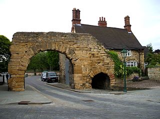
South Bridge is a road bridge and street in Edinburgh, Scotland, between the High Street and Chambers Street/Infirmary Street. It extends to North Bridge at the north and Nicolson Street at the south, forming a level roadway over the steep valley scoured parallel to the High Street when the crag and tail landscape was formed. The Cowgate roadway along the bottom of the valley runs under the largest arch of the bridge.

Tregirls is a farmstead in Cornwall, United Kingdom. It is situated approximately half-a-mile (1 km) north of Padstow. The settlement consists of a farm and converted cottages which are let as holiday accommodation.

Restronguet Creek is a tidal ria in south Cornwall, United Kingdom. It is a tributary of Carrick Roads, the estuary of the River Fal, and is situated approximately four miles (6.5 km) south of Truro and three miles (5 km) north of Falmouth.

Mylor Creek is a tidal ria in south Cornwall, United Kingdom. It is a tributary of Carrick Roads, the estuary of the River Fal and is situated approximately six miles (10 km) south of Truro and two miles (3 km) north of Falmouth .

Trevemper is a hamlet to the south of Newquay, Cornwall, United Kingdom, on the west bank of the River Gannel at the rivers lowest bridging point.

Frogmore and Sherford is a civil parish in Devon, England. Within it are the villages of Frogmore and Sherford. The parish was created in 1986 from Sherford and parts of South Pool and Charleton.

The River Lerryn is a river in east Cornwall, England, UK, a tributary of the River Fowey. The Lerryn is the largest of the tributaries which enter the estuary of the Fowey. The river is tidal up to the village of Lerryn. The landscape of the Lerryn catchment is rural and includes heathland, moorland and rough pasture in the upper reaches and broadleaf, coniferous and mixed plantation woodland in the lower. This catchment includes four SSSIs, including Redlake Meadows & Hoggs Moor. The Lerryn rises at Fairy Cross on the southern slopes of Bodmin Moor and flows south-southwest until it enters the Fowey estuary.
