
Bulgaria is a country situated in Southeast Europe that occupies the eastern quarter of the Balkan peninsula, being the largest country within its geographic boundaries. It borders Romania to the north, Serbia and North Macedonia to the west, Greece and Turkey to the south, and the Black Sea to the east. The northern border with Romania follows the river Danube until the city of Silistra. The land area of Bulgaria is 110,994 square kilometres (42,855 sq mi), slightly larger than that of Cuba, Iceland or the U.S. state of Tennessee. Considering its relatively compact territorial size and shape, Bulgaria has a great variety of topographical features. Even within small parts of the country, the land may be divided into plains, plateaus, hills, mountains, basins, gorges, and deep river valleys. The geographic center of Bulgaria is located in Uzana.

Sofia is the capital and largest city of Bulgaria. It is situated in the Sofia Valley at the foot of the Vitosha mountain, in the western part of the country. The city is built west of the Iskar river and has many mineral springs, such as the Sofia Central Mineral Baths. It has a humid continental climate. Being in the centre of the Balkans, it is midway between the Black Sea and the Adriatic Sea and closest to the Aegean Sea.
Tourism in Bulgaria is a significant contributor to the country's economy. Situated at the crossroads of the East and West, Bulgaria has been home to many civilizations: Thracians, Greeks, Romans, Eastern Romans or Byzantines, Slavs, Bulgars, and Ottomans. The country is rich in tourist sights and historical artifacts, scattered through a relatively small and easily accessible territory. Bulgaria is internationally known for its seaside and winter resorts.

A subterranean river is a river or watercourse that runs wholly or partly beneath the ground, one where the riverbed does not represent the surface of the Earth. It is distinct from an aquifer, which may flow like a river but is contained within a permeable layer of rock or other unconsolidated materials. A river flowing below ground level in an open gorge is not classed as subterranean.
Sofia Province is a province (oblast) of Bulgaria. The province does not include Sofia in its territories, but Sofia remains its administrative center. The province borders on the provinces of Pernik, Kyustendil, Blagoevgrad, Pazardzhik, Plovdiv, Lovech, Vratsa, Montana, and "Sofia City Province", and borders with Serbia to the northwest.

Vitosha, the ancient Scomius or Scombrus, is a mountain massif, on the outskirts of Sofia, the capital of Bulgaria. Vitosha is one of the symbols of Sofia and the closest site for hiking, alpinism and skiing. Convenient bus lines and rope ways render the mountain easily accessible. Vitosha has the outlines of an enormous dome.

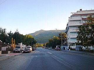
Samokov is a town in Sofia Province in the southwest of Bulgaria. It is situated in Samokov Valley between the mountain ranges of Rila, Vitosha and Sredna Gora, 55 kilometres from the capital Sofia. Due to the suitable winter sports conditions, Samokov, together with the nearby resort Borovets, is a major tourist centre.
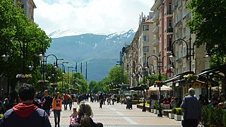
Vitosha Boulevard is the main commercial street in the centre of Sofia, the capital of Bulgaria, which has stores, restaurants and bars. It extends from the St Nedelya Square to the Southern Park. Many high-end fashion labels have outlets on Vitosha boulevard and the neighbouring streets: Versace, Escada, Bulgari, D&G, La Perla, Lacoste, Van Laak, Ermenegildo Zegna, Tru Trussardi, Moreschi, Marella, Max Mara, Gianfranco Ferré, Emporio Armani, Tommy Hilfiger, Boss, Baldinini. Among the notable buildings, located on the boulevard are: The National Palace of Culture, The Palace of the Courts, the house where the famous Bulgarian poet Peyo Yavorov lived and died. The corner of Vitosha and Patriarch Evtimiy boulevards, so called the Pharmacy, is a popular place for meetings.
Boyana is a neighbourhood of the Bulgarian capital of Sofia, part of Vitosha municipality and situated 8 km south of the city centre, in the outskirts of Vitosha. Boyana is one of the most expensive parts of Sofia to live in. The residents are primarily wealthy business people, government officials, and other prominent members of Bulgarian society. Formerly an outlying village, it was incorporated into Sofia in 1961.

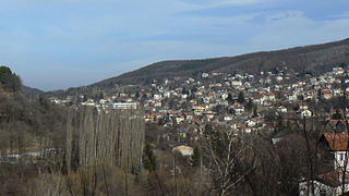
Dragalevtsi is a neighborhood of Sofia, which is located at the foot of Vitosha Mountain. It is part of the administrative district "Vitosha" of Sofia Municipality. Dragalevtsi is an affluent quarter built up with luxurious one-family country houses, villas, and hotels.

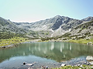
Kremenski Lakes are a glacial lake group in the Pirin mountain range, southwestern Bulgaria. They are located in the Pirin National Park, a UNESCO World Heritage Site. The group consists of nine lakes, seven permanent and two drying, in the narrow salient Kremenski cirque. Kremenski Lakes are surrounded by the summits of Sivria (2,591 m) to the northwest and Dzhano (2,668 m) to the southeast, as well as the Kremenski ridge which ends with Kremenski peak (2,503 m). They drain into the river Retizhe, a right tributary of the Mesta.
Vitosha is one of the 24 districts of Sofia, situated in the southern parts of the City on the foot of the Vitosha mountain. As of 2006 it has 42,953 inhabitants. The district includes 7 neighbourhoods: Boyana, Simeonovo, Dragalevtsi, Pavlovo, Buxton, Manastirski Livadi, and Knyazhevo as well as two villages Vladaya and Marchaevo. It is among the richest and greenest districts in Sofia and Bulgaria with many beautiful residences, houses, villas and residential complexes.
Vladaya is a village on the Vitosha and Lyulin mountains in western Bulgaria at an altitude of about 1000 m. In the 2011 census in Vladaya were counted 4043 residents, which makes it the tenth largest village in Bulgaria.
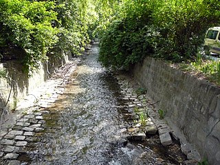
The Boyanska reka is a river in western Bulgaria, a left tributary to the river Perlovska.

Urvich is a medieval fortress in the territory of today's quarter Pancharevo, heir to the village of Glavishevo. It is located on the right riverside of Iskar River, in the hill of "Sredobardie", in the Lozen mountain, about 20 kilometres (12 mi) from Sofia downtown on the road to Samokov. In this region there is a river meander, which has been declared a natural landmark.
Opletnya is a village in Svoge Municipality, Sofia Province, western Bulgaria.
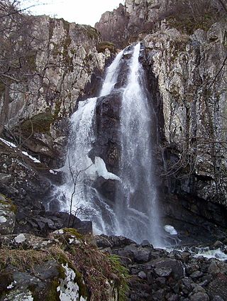
Boyana Waterfall is the largest waterfall in the Vitosha mountain massif in western Bulgaria, with a height of 25 meters.

Murgash is a peak in Bulgaria, in the Balkan Mountains mountain range. The peak is located in the East part of Murgash massive, with an altitude of 1,687 m (5,535 ft) above sea level.

Kladnitsa is a village in Southern Bulgaria. The village is located in Pernik Municipality, Pernik Province. Аccording to the numbers provided by the 2020 Bulgarian census, Kladnica currently has a population of 1277 people with a permanent address registration in the settlement.

The Zheleznishka reka is a river in western Bulgaria, a left tributary of the Iskar. The river is 11 km long and takes its source from the Kazana area on the eastern slopes of the Vitosha mountain range at an altitude of 1,677 m near the summits of Kazana, Golyam Kupen and Belcheva Skala. It flows in eastern direction until the confluence with the Ustruzhki Dol downstream of the village of Zheleznitsa. It then turns northeast. The river is also known as the Selska reka upstream and the Vedena downstream. Its largest tributary is the Egulya, which springs from the Plana mountain range. For about a kilometer along its banks near Zheleznitsa passes one of the main trails in Vitosha Nature Park, which leads to its highest summit, the Cherni Vrah (2,290 m). It its lower course the Zheleznishka reka forms a deep valley, which serves as the orographic boundary between Vitosha and Plana. It flows into the Iskar in the Pancharevo Gorge at the Devil's Bridge near the medieval Bulgarian fortress of Urvich, a starting point of a trail leading to the Kokalyane Monastery and Plana's highest summit Manastirishte (1,338 m).

