Bradfield, Zimbabwe

Last updated

Bradfield
Zimbabwe adm location map.svg
Red pog.svg
Bradfield
Map of Zimbabwe showing the location of Bradfield
Placement on map is approximate
Coordinates: 20°10′40″S28°35′06″E / 20.17778°S 28.58500°E / -20.17778; 28.58500
CountryFlag of Zimbabwe.svg  Zimbabwe
Province Matabeleland North
District Bulawayo District
City Bulawayo
Time zone CAT (UTC+2)

Bradfield is a neighbourhood in the city of Bulawayo, Zimbabwe.

Bulawayo Place in Zimbabwe

Bulawayo is the second largest city in Zimbabwe, and the largest city in the country's Matabeleland. The city's population is disputed; the 2012 census listed it at 653,337, while the Bulawayo City Council claimed it to be about 1.2 million. Bulawayo covers an area of about 1,707 square kilometres (659 sq mi) in the western part of the country, along the Matsheumhlope River. Along with the capital Harare, Bulawayo is one of two cities in Zimbabwe that are also a province.

Contents

Location

Bradfield is located in Bulawayo District, Matabeleland North Province, in the city of Bulawayo, the second-largest business and industrial center in Zimbabwe, after the capital, Harare, located approximately 460 kilometres (286 mi), by road, to the northeast. [1]

Matabeleland North Province Province in Zimbabwe

Matabeleland North is a province in western Zimbabwe. With a population of 749,017 as of the 2012 census, it is the country's second-least populous province, after Matabeleland South, and is the country's least densely populated province. Matabeleland North was established in 1974, when the original Matabeleland Province was divided into two provinces, the other being Matabeleland South. In 1997, the province lost territory when the city of Bulawayo became its own province. Matabeleland North is divided into seven districts. Its capital is Lupane, and Victoria Falls and Hwange are its largest towns. The name "Matabeleland" is derived from the Matabele or Ndebele people, the province's largest ethnic group.

Zimbabwe republic in southern Africa

Zimbabwe, officially the Republic of Zimbabwe, is a landlocked country located in southern Africa, between the Zambezi and Limpopo Rivers, bordered by South Africa, Botswana, Zambia and Mozambique. The capital and largest city is Harare. A country of roughly 16 million people, Zimbabwe has 16 official languages, with English, Shona, and Ndebele the most commonly used.

Harare City and Province in Zimbabwe

Harare is the capital and most populous city of Zimbabwe. The city proper has an area of 960.6 km2 (371 mi2) and an estimated population of 1,606,000 in 2009, with 2,800,000 in its metropolitan area in 2006. Situated in north-eastern Zimbabwe in the country's Mashonaland region, Harare is a metropolitan province, which also incorporates the municipalities of Chitungwiza and Epworth. The city sits on a plateau at an elevation of 1,483 metres above sea level and its climate falls into the subtropical highland category.

Bradfield is bordered by 16th Street to the north, Bulawayo Golf Club and Lions Golf Club to the east, 23rd Avenue and Burns Drive to the south and by Angus Road to the west. Matopos Road runs from 16th Street to 23rd Avenue, in a north to south direction in the neighbourhood. Hillside Road also runs in a north to south direction through the Bradfield. The geographic coordinates of the neighbourhood are:20° 10' 40.00"S, 28° 35' 6.00"E (Latitude:-20.177778; Longitude:28.585000).

Overview

Bradfield, Zimbabwe is an upscale residential and commercial neighbourhood in Bulawayo. Commercial enterprises like banks, doctors' and dentists' offices and a shopping mall are located on Hillside Road. Upscale single-family homes occupy the rest of the neighbourhood.

History

The suburb was named after Edwin Eugene Bradfield, one of the first Europeans to settle in the neighbourhood. [2]

Population

The exact population of Bradfield, Zimbabwe is not known as of August 2011.

Points of interest

The points of interest within Bradfield or close to its borders, include the following:

Ecobank Zimbabwe Limited (EZL), is a commercial bank in Zimbabwe. It is one of the commercial banks licensed by the Reserve Bank of Zimbabwe and a subsidiary of Togo-based Ecobank.

See also

Related Research Articles

Provinces of Zimbabwe

Provinces are constituent political entities of Zimbabwe. Zimbabwe currently has ten provinces, two of which are cities with provincial status. Zimbabwe is a unitary state, and its provinces exercise only the powers that the central government chooses to delegate. Provinces are divided into districts, which are divided into wards.

Carling Avenue

Carling Avenue is a major east–west arterial road in the west end of Ottawa, Ontario, Canada. It runs from March Road in Kanata to Bronson Avenue in the Glebe. The road is named for John Carling, founder of Carling Brewery and Conservative MP and Senator, Postmaster General and Minister of Agriculture.

Gwanda Town in Zimbabwe

Gwanda is a town in Zimbabwe located 126 kilometers south east of the city of Bulawayo, Zimbabwe's second largest city. It is the capital of the province of Matabeleland South, one of the 10 administrative provinces in the country. Gwanda's largest and oldest suburb Jahunda derives its name from the original Kalanga speaking inhabitants of the region who were known as Majaunda, a name derived from the words "Ja" meaning to eat and "Unda" meaning to move or go; a reference to their nomadic pastoral way of living as observed by later inhabitants. Towns and districts surrounding Gwanda include Mbalabala, West Nicholson, Filabusi, Esigodini and Matobo.

Rhodesia cricket team cricket team

The Rhodesia cricket team played first-class cricket and represented originally the British colony of Southern Rhodesia and later the unilaterally independent state of Rhodesia which became Zimbabwe. In 1980 the Rhodesia cricket team was renamed as the Zimbabwe-Rhodesia Cricket team, and in 1981 it adopted its current name of the Zimbabwe national cricket team.

Plumtree, Zimbabwe Place in Zimbabwe

Plumtree is a small town in Zimbabwe. Alongside marula trees, wild plum trees grew abundantly in the area, hence the name Plumtree.

This article describes the history of cricket in Zimbabwe from the 1992-93 season until the end of the country's involvement in Test cricket in 2006.

Nedbank Zimbabwe Limited, also Nedbank Zimbabwe, is a commercial bank in Zimbabwe. It is licensed by the Reserve Bank of Zimbabwe, the central bank and national banking regulator. The bank was previously known as MBCA Bank, prior to rebranding to its present name.

Standard Chartered Zimbabwe

Standard Chartered Zimbabwe is a commercial bank in Zimbabwe and a wholly owned subsidiary of Standard Chartered. It is licensed by the Reserve Bank of Zimbabwe, the central bank and national banking regulator.

Mpilo Central Hospital, more commonly known as Mpilo Hospital, is the largest hospital in Bulawayo, and second largest in Zimbabwe after Parirenyatwa Hospital in Harare. Mpilo is a public hospital, and referral centre for the Matabeleland North, Matabeleland South and Midlands provinces of Zimbabwe.

Chegutu District in Mashonaland West, Zimbabwe

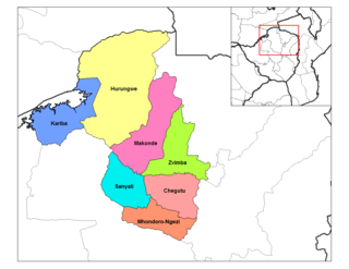
Chegutu District is a district of Mashonaland West Province, Zimbabwe.

College Hill, Wichita, Kansas Neighborhood in Sedgwick, Kansas, United States

College Hill is a historic, predominantly residential neighborhood in Wichita, Kansas, United States.

Not to be confused with NMB Bank Nepal, a commercial bank in Nepal

John Nyumbu is a Zimbabwean cricketer. He is right-handed tail-ended batsman and right arm off break bowler.

Luke Mafuwa Jongwe is a Zimbabwean cricketer. He is a right-handed batsman and right-arm medium pace bowler.

A5 Highway is a national road in Zimbabwe. It joins Harare and Bulawayo hence the name Harare-Bulawayo Highway popularly known as Harare-Bulawayo Road.

R5 road (Zimbabwe) road in Zimbabwe

R5 Highway is a 270.8 kilometres (168.3 mi) regional road corridor running from Harare to Mutare. It is one and the same national A3 Highway.

References

Photos

Coordinates: 20°10′40″S28°35′06″E / 20.177778°S 28.585000°E / -20.177778; 28.585000

Geographic coordinate system Coordinate system

A geographic coordinate system is a coordinate system that enables every location on Earth to be specified by a set of numbers, letters or symbols. The coordinates are often chosen such that one of the numbers represents a vertical position and two or three of the numbers represent a horizontal position; alternatively, a geographic position may be expressed in a combined three-dimensional Cartesian vector. A common choice of coordinates is latitude, longitude and elevation. To specify a location on a plane requires a map projection.