
The Great Plains, sometimes simply "the Plains", is a broad expanse of flatland located west of the Mississippi River and east of the Rocky Mountains, much of it covered in prairie, steppe and grassland. It is the southern and main part of North America's Interior Plains, which also include the tallgrass prairie between the Great Lakes and Appalachian Plateau, and the Taiga Plains and Boreal Plains ecozones in Northern Canada.

Trinity County is a county located in the U.S. state of Texas. As of the 2010 census, the population was 14,585. Its county seat is Groveton. The county is named for the Trinity River.

Montague County is a county located in the U.S. state of Texas, established in 1857. As of the 2010 census, its population was 19,719. The county seat is Montague. The county was created in 1857 and organized the next year. It is named for Daniel Montague, a surveyor and soldier in the Mexican–American War. Republican Drew Springer, Jr., a businessman from Muenster in Cooke County, represents Montague County in the Texas House of Representatives. He carried the county in the 2012 Republican runoff election.

Angelina County is a county located in the U.S. state of Texas. As of the 2010 census, the population was 86,771. Its county seat is Lufkin. It was formed in 1846 from Nacogdoches County. It is named for a Hasinai Native American woman who assisted early Spanish missionaries and was named Angelina by them. It is a wet county as of November 2006, after a wet/dry election. In November 2007 the small community of Burke was the only city in it to return to dry status.

St. Landry Parish is a parish located in the U.S. state of Louisiana. As of the 2010 census, the population was 83,384. The parish seat is Opelousas. The parish was created in 1807.

Amity is a city in Clark County, Arkansas, United States. The population was 723 at the 2010 census. The city began on the Caddo River in the mid-19th century when William F. Browning and others, including A.B. Clingman, at various times moved to the area.
Opelousas is a small city in, and the parish seat of, St. Landry Parish, Louisiana, United States. Interstate 49 and U.S. Route 190 were constructed with a junction here. According to the 2020 census, Opelousas has a population of 15,547, and is currently declining at a rate of -1.16% annually and its population has decreased by -6.53% since the most recent census, which recorded a population of 16,634 in 2010. Opelousas is the principal city for the Opelousas-Eunice Micropolitan Statistical Area, which had an estimated population of 92,178 in 2008. Opelousas is also the fourth largest city in the Lafayette-Acadiana Combined Statistical Area, which has a population of 537,947.
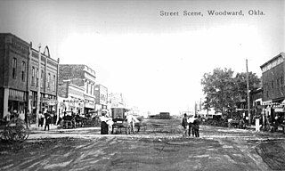
Woodward is a city in and the county seat of Woodward County, Oklahoma, United States. It is the largest city in a nine-county area. The population was 12,051 at the 2010 census.

Burke is a city in southwestern Angelina County, Texas, United States. The population was 737 at the 2010 census.
Rockport is a city in Aransas County, Texas, United States. The population was 8,766 at the 2010 census. It is the county seat.

Panhandle is the county seat of Carson County, Texas, United States. The population of the town was 2,452 at the 2010 census. Panhandle is part of the Amarillo metropolitan statistical area.

Grand Prairie is a city in Dallas County, Tarrant County, and Ellis County, Texas, in the United States. It is part of the Mid-Cities region in the Dallas–Fort Worth metroplex. It has a population of 175,396 according to the 2010 census, making it the fifteenth most populous city in the state.
East Texas is a distinct cultural, geographic, and ecological region in the U.S. state of Texas.
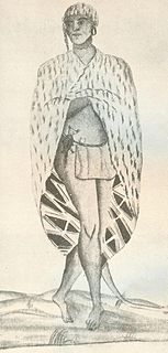
The Atakapa, were an indigenous people of the Southeastern Woodlands, who spoke the Atakapa language and historically lived along the Gulf of Mexico. The competing Choctaw people used this term for this people, and European settlers adopted the term from them. The Atakapan people were made up of several bands. They called themselves the Ishak, which translates as "the people." Within the Ishak there were two moieties which the Ishak identified as "The Sunrise People" and "The Sunset People". Although the people were decimated by infectious disease after European contact and declined as a people, survivors joined other nations.

The American Bottom is the flood plain of the Mississippi River in the Metro-East region of Southern Illinois, extending from Alton, Illinois, south to the Kaskaskia River. It is also sometimes called "American Bottoms". The area is about 175 square miles (450 km2), mostly protected from flooding in the 21st century by a levee and drainage canal system. Immediately across the river from St. Louis, Missouri, are industrial and urban areas, but many swamps and the major Horseshoe Lake are reminders of the Bottoms' riparian nature. This plain served as the center for the pre-Columbian Cahokia Mounds civilization, and later the French settlement of Illinois Country. Deforestation of the river banks in the 19th century to fuel steamboats had dramatic environmental effects in this region. The Mississippi River between St. Louis and the confluence with the Ohio River became wider and more shallow, as unstable banks collapsed into the water. This resulted in more severe flooding and lateral changes of the major channel, causing the destruction of several French colonial towns, such as Kaskaskia, which relocated; Cahokia, and St. Philippe, Illinois.

Hanley is a town in Division No. 11 in Saskatchewan, Canada. It is located 65 km south of Saskatoon. The town's population in 2011 was 522. It was named after Hanley, Staffordshire, England, by early founders. It is also the seat for the rural municipality of Rosedale.

The economy of the State of Texas is the second largest by GDP in the United States after that of California. It has a gross state product of $1.887 trillion as of 2019. As of 2015, Texas is home to six of the top 50 companies on the Fortune 500 list and 51 overall. In 2017, Texas grossed more than $264.5 billion a year in exports—more than the exports of California and New York combined.
The history of Fort Worth, Texas, in the United States is closely intertwined with that of northern Texas and the Texan frontier. From its early history as an outpost and a threat against Native American residents, to its later days as a booming cattle town, to modern times as a corporate center, the city has changed dramatically, although it still preserves much of its heritage in its modern culture.

Spanish Fort is an unincorporated community in north central Montague County, Texas, United States at the end of Farm Road 103 one mile south of the Red River.

Preston, also known as Preston Bend, is an unincorporated community and census-designated place located on the Red River in Grayson County, Texas, United States. It grew in the 19th century at the intersection of several military and trade roads and was an important crossing on the Shawnee cattle trail. Preston lost prominence after the MK&T railroad bypassed the town to the east, leading to a decline in traveler and cattle drive traffic. Much of its former town site is submerged beneath the waters of Lake Texoma. Its population was 2,096 as of the 2010 census.