
Minganie is a regional county municipality in the Côte-Nord region of Quebec, Canada. It includes Anticosti Island. Its seat is Havre-Saint-Pierre.

Basse-Côte-Nord Territory was a territory equivalent to a regional county municipality (TE) in eastern Quebec, Canada. The territory, whose geographical code was 982, was formed in 2002 when it separated from the Minganie Regional County Municipality and was superseded by Le Golfe-du-Saint-Laurent Regional County Municipality that was formed in July 2010.

Lourdes-de-Blanc-Sablon Airport,, is located 2 nautical miles north of Blanc-Sablon, Le Golfe-du-Saint-Laurent Regional County Municipality, in administrative region of Côte-Nord, Quebec, Canada.

Blanc-Sablon is the easternmost community in Le Golfe-du-Saint-Laurent Regional County Municipality, in the administrative région of Côte-Nord, in the province of Quebec, Canada. With a population of 1,118 inhabitants, it is the most populous community in the county municipality.

Côte-Nord-du-Golfe-du-Saint-Laurent is a municipality in the regional county municipality of Le Golfe-du-Saint-Laurent in the Côte-Nord region of the province of Quebec, Canada. The municipality consists of two non-contiguous areas, both along the shores of the Gulf of Saint Lawrence. The larger main part stretches from the Natashquan River to the Gros Mécatina River and includes all populated places. The eastern part is a small section between Middle Bay and Brador.
The Kedgwick River is a tributary of the head of the Restigouche River, in New Brunswick, in Canada. It flows southeast in:
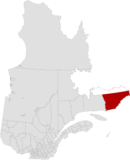
Le Golfe-du-Saint-Laurent is a regional county municipality in the Côte-Nord region of far-eastern Quebec, Canada. It includes all communities along the Gulf of Saint Lawrence between the Natashquan River and the Newfoundland and Labrador border.

The Natashquan is a river in the Canadian provinces of Quebec and Newfoundland and Labrador. It flows south into the Gulf of Saint Lawrence.

Blanc-Sablon Bay is a natural bay in municipality of Blanc-Sablon, in Le Golfe-du-Saint-Laurent Regional County Municipality, on the Côte-Nord (North-Shore) coast of Gulf of Saint Lawrence, in the province of Quebec, Canada.

The Centre de services scolaire du Littoral is a geographically-based school service centre in Quebec, Canada, with offices in Sept-Îles and Chevery.
Blanc-Sablon may refer to:

The River Musquaro flows south in the municipality of Côte-Nord-du-Golfe-du-Saint-Laurent, Quebec, in the Le Golfe-du-Saint-Laurent Regional County Municipality, in the administrative region of Côte-Nord (North-Shore), in Quebec, in Canada.
The river Chimenticook is a tributary of the Saint John River, flowing in the canton T13 R13 Wels, in the Aroostook County, in North of Maine, in United States.
The Iroquois River is a tributary of the Saint John River emptying in New Brunswick, in Canada. This river flows into the Notre Dame Mountains, in the municipality of Dégelis, Quebec, in Temiscouata Regional County Municipality (RCM), in administrative region of Bas-Saint-Laurent, in Quebec; and in the Madawaska County, in New Brunswick, in Canada.

The Kegaska River is a salmon river flowing on North shore of Estuary of Saint Lawrence. It crosses the unorganized territory of Petit-Mécatina, in the Le Golfe-du-Saint-Laurent Regional County Municipality, in the administrative region in the Côte-Nord, in the province of Quebec, Canada.
The Chécatica River is a salmon river in the Côte-Nord region of Quebec, Canada. It empties into the Gulf of Saint Lawrence.
The Belles Amours River is a salmon river in the Côte-Nord region of Quebec, Canada. It empties into the Gulf of Saint Lawrence.
The lac Émeraude is located in the northern part of the municipality of Saint-Ubalde, in the MRC of Portneuf Regional County Municipality, in the administrative region of the Capitale-Nationale, in the province of Quebec, in Canada.
The Lac Blanc is located in the northern part of the municipality of Saint-Ubalde, in the MRC of Portneuf Regional County Municipality, in the administrative region of the Capitale-Nationale, in the province of Quebec, in Canada.
Simard Lake is a freshwater body of the unorganized territory of Petit-Mécatina and the municipality of Kegaska, in the Le Golfe-du-Saint-Laurent Regional County Municipality, in the administrative region of Côte-Nord, in the province of Quebec, in Canada.

