
Chinatown is a community in Southwest Houston, Texas, United States.

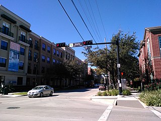
Montrose is an area located in west-central Houston, Texas, United States and is one of the city's major cultural areas. Montrose is a 7.5 square miles (19 km2) area roughly bounded by Interstate 69/U.S. Highway 59 to the south, Allen Parkway to the north, South Shepherd Drive to the west, and Taft to Fairview to Bagby to Highway 59 to Main to the east. Montrose neighborhoods include Cherryhurst, Courtlandt Place, Hyde Park, Montrose, Vermont Commons, North and East Montrose, Mandell Place and Winlow Place. Montrose is also less well known by the moniker Neartown, encompassing Superneighborhood #24.
Midtown is a central neighborhood of Houston, located west-southwest of Downtown. Separated from Downtown by an elevated section of Interstate 45, Midtown is characterized by a continuation of Downtown's square grid street plan, anchored by Main Street and the METRORail Red Line. Midtown is bordered by Neartown (Montrose) to the west, the Museum District to the south, and Interstate 69 to the east. Midtown's 325 blocks cover 1.24 square miles (3.2 km2) and contained an estimated population of nearly 8,600 in 2015.

Spring Branch is a district in west-northwest Harris County, Texas, United States, roughly bordered by Tanner Road and Hempstead Road to the north, Beltway 8 to the west, Interstate 10 to the south, and the 610 Loop to the east; it is almost entirely within the city of Houston. Established by the Texas Legislature, the Spring Branch Management District exercises jurisdiction over the area.

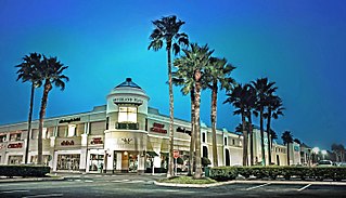
Sharpstown is a master-planned community in the Southwest Management District, Southwest Houston, Texas. It was one of the first communities to be built as a master-planned, automobile centered community and the first in Houston. Frank Sharp (1906–1993), the developer of the subdivision, made provisions not only for homes but also for schools, shopping and recreation areas. While this model has been duplicated countless times in the past fifty years, at the time it was quite revolutionary, attracting national media attention. The development was dedicated on March 13, 1955.
Alief is a working-class suburb in Southwest Harris County, Texas, United States. Most of Alief is within the city limits of Houston, while a portion of the community is in unincorporated Harris County.

Upper Kirby is a commercial district in Houston, Texas, United States. It is named after Kirby Drive, so indirectly takes its name from John Henry Kirby.
Meyerland is a community in southwest Houston, Texas, outside of the 610 Loop and inside Beltway 8. The neighborhood is named after the Meyer family, who bought and owned 6,000 acres (24 km2) of land in southwest Houston.

Braeswood Place is a group of subdivisions in Harris County, Texas, United States. The vast majority of the land is in Houston while a small part is in Southside Place.

Acres Homes is a neighborhood located in northwest Houston, Texas. The 9-square-mile (23 km2) mile area is loosely bounded by the city limits and West Gulf Bank Road to the north; Pinemont Drive to the south; North Shepherd Drive to the east; and Alabonson Drive to the west. Historically, it has been predominantly African American. Unincorporated for decades, it was annexed to Houston in 1967.

Sunnyside is a community in southern Houston, Texas, United States, south of Downtown Houston.

Third Ward is an area of Houston, Texas, United States, that evolved from one of the six historic wards of the same name. It is located in the southeast Houston management district.
Independence Heights is a community in Houston, Texas, bordered by 40th Street to the north, Yale Street to the west, the 610 Loop to the south, and Airline Drive to the east. The Super Neighborhood boundary created by the City of Houston is bordered by Tidwell to the north, Shepherd Drive to the west, the 610 Loop to the south, and Interstate 45 to the east.

Braeburn is a community of subdivisions in southwest Houston, Texas along Brays Bayou west of Hillcroft Avenue and south of the Sharpstown community. The first of these middle class subdivisions was developed after World War II at a time when the Richmond Farm-to-Market Road provided the route into the city, rather than U.S. Highway 59. Development continued into the 1970s. The Braeburn Country Club is located in the center of the community. Subdivisions found here include Robindell, Braeburn Terrace, Braeburn Glen, Larkwood, Braeburn Valley, Bonham Acres, Braes Timbers and—the acreage lot subdivision—Brae Acres. The area also includes commercial and multi-family developments. Braeburn is notable for its large number of mid-century modern homes, tree lined streets, and location close to the Galleria, the Texas Medical Center, Reliant Park, the major freeways- 59, 610 and the Beltway. The communities of Braeburn have in recent years formed the Braeburn Superneighborhood, a coalition of Home Owner Associations, in order to interact more effectively with the City of Houston and other area agencies. The Brays Bayou hike and bike trail runs through the community, providing easy access to over 15 miles of excellent trails.
Riverside Terrace is a neighborhood in Houston, Texas, United States. It is along Texas State Highway 288 and north of the Texas Medical Center and located near Texas Southern University and University of Houston. There about 20 sections of Riverside Terrace that span across North and South MacGregor. The community, formerly an affluent Jewish neighborhood, became an affluent community for African Americans in the 1950s and '60s. It is still predominantly African American neighborhood with different income levels. It has been undergoing a gradual change in demographics and aesthetics due to gentrification efforts since the early 2000s.

Brays Oaks, formerly known as Fondren Southwest, is an area in Southwest Houston, Texas, United States. The Brays Oaks Management District, also known as the Harris County Improvement District #5, governs the Brays Oaks area as well as other surrounding areas, such as Westbury. The City of Houston also defines the Brays Oaks Super Neighborhood, with separate boundaries.

Southwest Management District, formerly Greater Sharpstown Management District, is a district in Houston, Texas, United States. The district is split into 6 neighborhoods: Sharpstown, Chinatown, Mahatma Gandhi District/Little India, Westwood, Harwin, and University.

Riverstone is a 3,700-acre (15 km2) upscale master-planned residential community in Fort Bend County, Texas, United States. Approximately 18,000 residents ultimately will live in 6,000 homes. The development is largely located in unincorporated areas that are in extraterritorial jurisdictions (ETJ) of Sugar Land and Missouri City, with portions being in Missouri City proper and strips of land being in Sugar Land proper.

Uptown is a PID and a dense neighborhood in Dallas, Texas. Uptown is north of and adjacent to downtown Dallas, and is bordered by US 75 on the east, N Haskell Avenue on the northeast, the Katy Trail on the northwest, Bookhout Street and Cedar Springs Road on the west, N Akard Street on the southwest and Spur 366 on the south.

Knollwood Village is a subdivision in Houston, Texas. It is managed by the Knollwood Village Civic Club (KVCC), which governs Knollwood Village sections 1-10 and Braes Terrace II.