The Garden Route is a 300-kilometre (190 mi) stretch of the south-eastern coast of South Africa which extends from Witsand in the Western Cape to the border of Tsitsikamma Storms River in the Eastern Cape. The name comes from the verdant and ecologically diverse vegetation encountered here and the numerous estuaries and lakes dotted along the coast. It includes towns such as Knysna, Plettenberg Bay, Mossel Bay, Oudtshoorn, Great Brak River, Little Brak River, Wilderness, Sedgefield and Nature's Valley; with George, the Garden Route's largest city and main administrative centre.

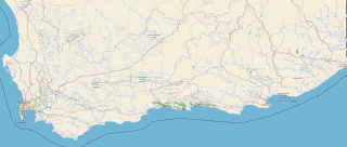
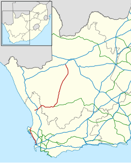
Mossel Bay Municipality is a municipality located in the Western Cape Province of South Africa. As of 2011 the population was 89,430.
The R27 is a provincial route in South Africa that consists of two disjoint segments. The first segment, also known as the West Coast Highway, connects Cape Town with Velddrif along the West Coast. The second runs from Vredendal via Vanrhynsdorp, Calvinia, Brandvlei and Kenhardt to Keimoes on the N14 near Upington. The connection between Velddrif and Vredendal has never been built, although it can be driven on various gravel roads.
Blouberg Local Municipality is a municipality in the Limpopo Province, northern South Africa, bordering Botswana. It takes its name from the Blouberg, a mountain range located to the west of the western end of the Soutpansberg mountain range, north west of the town of Vivo. Blouberg is home to some of the most spectacular rock climbing in South Africa. The rock climbing destination is famous for its big wall natural climbing with route lengths up to 350m. The vegetation ranges from sub-tropical savanna at the base, to alpine near the summit.

The Soutpansberg, meaning "Salt Pan Mountain" in Afrikaans, is a range of mountains in far northern South Africa. It is located in Vhembe District, Limpopo. It is named for the salt pan located at its western end. The mountain range reaches the opposite extremity in the Matikwa Nature Reserve, some 107 kilometres (66 mi) due east. The range as a whole had no Venda name, as it was instead known by its sub-ranges which include Dzanani, Songozwi and others. Of late it is however known as Tha vhani ya muno, meaning "mountain of salt".
Vivo is a small farming town in the Blouberg Local Municipality of the Capricorn District Municipality in the northern part of Limpopo province, South Africa.
Melkbosstrand is a coastal town located on the South West Coast of South Africa, 30 km north of Cape Town. It forms part of the City of Cape Town Metropolitan Municipality, the municipality governing Cape Town and its greater metropolitan area.
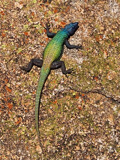
The common flat lizard is a species of lizard in the Cordylidae family. This lizard has 9 subspecies, all living in southern Africa.
The Sand River or Polokwane River is a watercourse in Limpopo Province, South Africa, a right hand tributary of the Limpopo River. Its new name "Polokwane River" is homonymous with the name of the town of Polokwane, formerly Pietersburg, about 200 kilometres (120 mi) upriver from its mouth. The Sand River flows by the western edge of this town.

Parklands is a suburb of Cape Town, South Africa. It is near Blouberg, bordered by Tableview, Cape Town and is part of the Western Seaboard residential district.

Blouberg Nature Reserve is a protected area situated close to Vivo, west of Louis Trichardt in the Limpopo Province, of South Africa. It covers an area of 9,360 hectares from the eastern portion of the Blouberg mountain range down to the savanna near the Brak River, and is founded by Peter Dix but was sold and now managed and administrated by the Limpopo Provincial Government.
Langjan Nature Reserve, is situated in Limpopo province, South Africa, on the R521 to Alldays, west of Makhado, close to the Blouberg Nature Reserve
Soutpansberg Conservancy, also known as Western Soutpansberg Conservancy, is a protected area situated in the northern part of the Limpopo province of South Africa. The reserve has an area of about 90,000 Ha and consists mostly in the mountainous terrain of the western part of the Soutpansberg Range. The Brak River, a tributary of the Sand River, flows beyond the western end of the Soutpansberg Conservancy. The Waterpoort, the deep gorge cut by the Sand River across the range is located in the central part of the protected area.
The Great Brak River is a river in the Western Cape, South Africa. The mouth of the river lies at the town of Great Brak River which falls under the Mossel Bay Municipality. The nearest towns are Mossel Bay, 24 km to the west, and the largest town in the southern Cape George, 34 km to the east by road.

Little Brak River or Klein Brak River is a river in the Western Cape province of South Africa. Its tributaries include the Brandwag River and Moordkuil River. It falls within the Drainage system K.

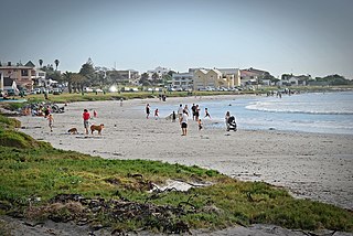
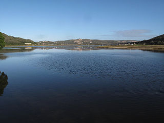
Great Brak River is a coastal village in the Mossel Bay Local Municipality in the Western Cape province of South Africa. It is a historic village built around the lagoon of the Great Brak River, 17 kilometres (11 mi) north-northeast of the town of Mossel Bay.
Little Brak River is a settlement in Garden Route District Municipality in the Western Cape province of South Africa.
Senwabarwana is a town in the Blouberg Local Municipality of the Capricorn District Municipality in the Limpopo province of South Africa. The town is the seat of the Blouberg Local Municipality. It is located about 93 km northwest of the city Polokwane.
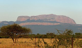
The Blouberg, meaning "Blue Mountain" in Dutch, is a range of mountains in Limpopo Province, at the far north of South Africa. It is located in Blouberg Local Municipality, Capricorn District. The mountain is entrenched in the history of the local Northern Sotho people, and they have different names for its various parts.
Great Brak River, Groot Brak River, Groot Brak Rivier and similar titles may refer to:
