Bramarpura

Last updated
Bhramarpura

भ्रमरपुरा
Nepal adm location map.svg
Red pog.svg
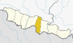
Bhramarpura
Location in Nepal
Coordinates: 26°44′N85°52′E / 26.73°N 85.86°E / 26.73; 85.86 Coordinates: 26°44′N85°52′E / 26.73°N 85.86°E / 26.73; 85.86
CountryFlag of Nepal.svg    Nepal
Zone Janakpur Zone
District Mahottari District
Population
 (2011)
  Total9,458
Time zone UTC+5:45 (Nepal Time)

Bhramarpura is a village development committee in Mahottari District in the Janakpur Zone of south-eastern Nepal. At the time of the 2011 Nepal census it had a population of 9458 people living in 1734 individual households. [1]

Village development committee (Nepal) lower administrative part of Nepals local development ministry

A Village Development Committee (VDC) in Nepal was the lower administrative part of its Ministry of Federal Affairs and Local Development. Each district had several VDCs, similar to municipalities but with greater public-government interaction and administration. There were 3,157 village development committees in Nepal. Each VDC was further divided into several wards depending on the population of the district; the average being nine wards.

Mahottari District District in Province No. 2, Nepal

Mahottari District, a part of Province No. 2, is one of the seventy-seven districts of Nepal. The district, with Jaleshwar as its district headquarters, covers an area of 1,002 km² and had a population of 553,481 in 2001 and 627,580 in 2011. Its headquarters is located in Jaleshwar, a neighbouring town of the historical city of Janakpur. The name Jaleshwar means the 'God in Water'. One can find a famous temple of Lord Shiva in Water there. Jaleshwar lies at a few kilometres distance from the Nepal-India border and has a majority Maithili population. In janakpur zone there are two districts ; mahottari and dhanusha and both are in a distance of 1 hour.

Janakpur Zone Zone in Central Development Region, Nepal

Janakpur is one of the fourteen zones of Nepal, reaching from the Indian border in the south to the Tibetan border in the north and Sagarmatha Zone in the east and Bagmati and Naryani Zones in the west.

Related Research Articles

Bharatpur may refer to:

Islam in Nepal

Islam is a minority religion in Nepal. According to the 2011 Nepal census, Nepal has 1 million Muslims comprising 4.4% of the population of Nepal.

Jaleshwar mega city in Janakpur Zone

Jaleshwar is a municipality in Janakpur Zone, Nepal, and the headquarters of Mahottari District of Province No. 2 in Nepal. It is located in the Terai, on the border with India at Sursand, Bihar, and has a customs checkpoint.

Aurahi, Mahottari Municipality in Central, Nepal

Aurahi is a municipality in Mahottari District in Province No. 2 of Nepal. It was formed in 2016 occupying current 9 sections (wards) from previous 9 former VDCs. It occupies an area of 35.73 sq. km with a total population of 31,751.

Bardibas Municipality in Janakpur Zone, Nepal

Bardibas is a former VDC in Mahottari District in the Janakpur Zone of south-eastern Nepal. It was merged with Gaurivas, Kisan Nagar and Maisthan VDCs to form Bardibas Municipality.

Bhangaha Municipality in Central, Nepal

Bhangaha is a municipality in Mahottari District in Province No. 2 of Nepal. It was formed in 2016 occupying current 9 sections (wards) from previous 9 VDCs. It occupies an area of 77.21 sq. km with a total population of 46,754.

Gaidha Bhetpur Village development committee in Janakpur Zone, Nepal

Gaidha Bhetpur is a village development committee in Mahottari District in the Janakpur Zone of south-eastern Nepal. At the time of the 2011 Nepal census it had a population of 5250.

Gaushala, Mahottari Municipality in Central, Nepal

Gaushala is a municipality in Mahottari District in Province No. 2 of Nepal. The municipality was established on 18 May 2014 by merging existing Nigauli, Ramnagar, Gaushala VDCs. It occupies an area of 144.73 sq. km with a total population of 66,673.

Loharpatti Municipality in Central, Nepal

Loharpatti is a municipality in Mahottari District in Province No. 2 of Nepal. It was formed in 2016 occupying current 9 sections (wards) from previous 9 former VDCs. It occupies an area of 50.06 sq. km with a total population of 39,571.

Matihani, Mahottari Municipality in Central, Nepal

Matihani is a municipality in Mahottari District in Province No. 2 of Nepal. It was formed in 2016 occupying current 9 sections (wards) from previous 9 former VDCs. It occupies an area of 50.06 sq. km with a total population of 31,026.

Ramgopalpur Municipality in Central, Nepal

Ramgopalpur is a municipality in Mahottari District in Province No. 2 of Nepal. It was formed in 2016 occupying current 9 sections (wards) from previous 9 former VDCs. It occupies an area of 39.54 sq. km with a total population of 29,612.

Mahottari Rural Municipality Rural Municipality in Central, Nepal

Mahottari is a rural municipality in Mahottari District in Province No. 2 of Nepal. It was formed in 2016 occupying current 6 sections (wards) from previous 6 former VDCs. It occupies an area of 28.08 sq. km with a total population of 27,430.

Manara Shiswa Municipality in Central, Nepal

Manara Shiswa is a municipality in Mahottari District in Province No. 2 of Nepal. It was formed in 2016 occupying current 10 sections (wards) from previous 10 former VDCs. It occupies an area of 49.73 sq. km with a total population of 49,692.

Ekdara Rural Municipality in Central, Nepal

Ekdara is a rural municipality in Mahottari District in Province No. 2 of Nepal. It was formed in 2016 occupying current 6 sections (wards) from previous 6 former VDCs. It occupies an area of 24 sq. km with a total population of 29,315.

Samsi Rural Municipality Rural Municipality in Central, Nepal

Samsi is a rural municipality in Mahottari District in Province No. 2 of Nepal. It was formed in 2016 occupying current 7 sections (wards) from previous 7 former VDCs. It occupies an area of 21.57 sq. km with a total population of 33,791.

Sonama Rural Municipality Rural Municipality in Central, Nepal

Sonama is a rural municipality in Mahottari District in Province No. 2 of Nepal. It was formed in 2016 occupying current 8 sections (wards) from previous 8 former VDCs. It occupies an area of 57.77 sq. km with a total population of 38,747.

References

  1. VDC: Bramarpura, correct name Bhramarpura (PDF), archived from the original (PDF) on 2014-05-24.