
Ford Madox Brown was a British painter of moral and historical subjects, notable for his distinctively graphic and often Hogarthian version of the Pre-Raphaelite style. Arguably, his most notable painting was Work (1852–1865). Brown spent the latter years of his life painting the twelve works known as The Manchester Murals, depicting Mancunian history, for Manchester Town Hall.

Ford Madox Ford was an English novelist, poet, critic and editor whose journals The English Review and The Transatlantic Review were important in the development of early 20th-century English and American literature.
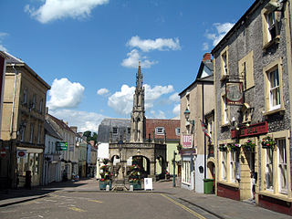
Shepton Mallet is a market town and civil parish in Somerset, England, some 16 miles southwest of Bath, 18 miles south of Bristol and five miles east of Wells. It had an estimated population of 10,810 in 2019. Mendip District Council was based there. The Mendip Hills lie to the north and the River Sheppey runs through the town, as does the route of the Fosse Way, the main Roman road between north-east and south-west England. There is evidence of Roman settlement. Its listed buildings include a medieval parish church. Shepton Mallet Prison was England's oldest, but closed in March 2013. The medieval wool trade gave way to trades such as brewing in the 18th century. It remains noted for cider production. It is the closest town to the Glastonbury Festival and nearby the Royal Bath and West of England Society showground.
This article contains information about the literary events and publications of 1914.
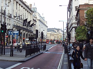
Piccadilly is a road in the City of Westminster, London, England, to the south of Mayfair, between Hyde Park Corner in the west and Piccadilly Circus in the east. It is part of the A4 road that connects central London to Hammersmith, Earl's Court, Heathrow Airport and the M4 motorway westward. St James's is to the south of the eastern section, while the western section is built up only on the northern side. Piccadilly is just under 1 mile (1.6 km) in length, and it is one of the widest and straightest streets in central London.

St Stephen's House is a theological college in Oxford, England affiliated with the Church of England. From 2003 to 2023 it was a permanent private hall of the University of Oxford.
Brunswick Square is a 3-acre (1.2 ha) public garden and ancillary streets along two of its sides in Bloomsbury, in the London Borough of Camden. It is overlooked by the School of Pharmacy and the Foundling Museum to the north; the Brunswick Centre to the west; and International Hall to the south. East is an enclosed area of playgrounds with further trees, Coram's Fields, associated with charity Coram Family which is just over double its size; next to that area Brunswick Square is mirrored, symmetrically by Mecklenburgh Square, likewise of 3 acres including roads. The squares are named after contemporary Queen consorts.

Eynsham is a village and civil parish in the West Oxfordshire district, in Oxfordshire, England, about 5 miles (8 km) north-west of Oxford and east of Witney. The 2011 Census recorded a parish population of 4,648. It was estimated at 5,087 in 2020.

Fitzroy Square is a Georgian square in London, England. It is the only one in the central London area known as Fitzrovia. The square is one of the area's main features, this once led to the surrounding district to be known as Fitzroy Square or Fitzroy Town and latterly as Fitzrovia, though the nearby Fitzroy Tavern is thought to have had as much influence on the name as Fitzroy Square.

Billingford is a village and civil parish in the Breckland district of Norfolk, England, about 3+1⁄2 miles (5.6 km) north of East Dereham. The village is just north of the River Wensum, which forms the southern boundary of the parish. The village is on the B1145 road, which links King's Lynn and Mundesley. The 2011 Census recorded the parish population as 253.

Broad Street is a wide street in central Oxford, England, just north of the former city wall. The street is known for its bookshops, including the original Blackwell's bookshop at number 50, located here due to the University of Oxford. Among residents, the street is traditionally known as The Broad.

St Pancras and Islington Cemetery is a cemetery in East Finchley, North London. Although it is situated in the London Borough of Barnet, it is run as two cemeteries, owned by two other London Boroughs, Camden and Islington. The fence along the boundary which runs west to east between the two parts of the cemetery has been removed, although the line of it is still marked.

Fittleworth is a village and civil parish in the District of Chichester in West Sussex, England located seven kilometres (4 miles) west from Pulborough on the A283 road and three miles (5 km) south east from Petworth. The village has an Anglican church, a primary school and one pub, The Swan. It is within the ancient divisions of the Bury Hundred and the Rape of Arundel. The village is bounded south by the Rother Navigation.
Francis Hueffer was a German-English writer on music, music critic, and librettist.
Sandford St Martin is a village and civil parish in West Oxfordshire about 7 miles (11 km) east of Chipping Norton and about 12 miles (19 km) south of Banbury. The 2011 Census recorded the parish's population as 209.

St Edmund's Church is the Roman Catholic parish church of Godalming, a town in the English county of Surrey. It was built in 1906 to the design of Frederick Walters and is a Grade II listed building. The church stands on a "dramatic hillside site" on the corner of Croft Road just off Flambard Way close to the centre of the town.

Glebe Place is a street in Chelsea, London. It runs roughly north to south from King's Road to the crossroads with Upper Cheyne Row, where it becomes Cheyne Row, leading down to Cheyne Walk and the River Thames. It also has a junction with Bramerton Street. The street was known as Cook's Ground for some period up to the mid-nineteenth century.
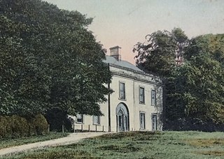
Busby Hall is a Grade II* listed Country House in Little Busby, North Yorkshire, England, close to the village of Carlton-in-Cleveland. The house and parkland sits within the North York Moors National Park.

Church Row is a residential street in Hampstead in the London Borough of Camden. Many of the properties are listed on the National Heritage List for England. The street runs from Frognal in the west to Heath Street in the east. St John-at-Hampstead and its additional burial ground is at the west end of the street.

Chiswick High Road is the principal shopping and dining street of Chiswick, a district in the west of London. It was part of the main Roman road running west out of London, and remained the main road until the 1950s when the A4 was built across Chiswick. By the 19th century the road through the village of Turnham Green had grand houses beside it. The road developed into a shopping centre when Chiswick became built up with new streets and housing to the north of Old Chiswick, late in the 19th century. There are several listed buildings including public houses, churches, and a former power station, built to supply electricity to the tram network.


