The Grove Mountains are a large, scattered group of mountains and nunataks extending over an area of approximately 40 by 20 miles, located 100 miles (160 km) east of the Mawson Escarpment in American Highland, Antarctica. They were first photographed from the air by aircraft of U.S. Navy Operation Highjump, 1946–47, and named by the Antarctic Names Committee of Australia for Squadron Leader I.L. Grove, a Royal Australian Air Force pilot with the Australian National Antarctic Research Expeditions, who made a November 1958 landing in these mountains.
Wilson Hills is a group of scattered hills, nunataks and ridges that extend NW-SE for about 110 kilometres (68 mi) between Matusevich Glacier and Pryor Glacier in Antarctica. They were discovered by Lieutenant Harry Pennell, Royal Navy, on the Terra Nova Expedition in February 1911 during Robert Falcon Scott's last expedition, and named after Dr. Edward A. Wilson, a zoologist with the expedition, who perished with Scott on the return journey from the South Pole.
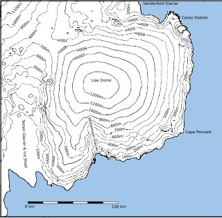
Williamson Glacier is a glacier draining northeastward from Law Dome into Colvocoresses Bay. Delineated by G.D. Blodgett (1955) from air photos taken by U.S. Navy Operation Highjump (1946–47). Named by Advisory Committee on Antarctic Names (US-ACAN) after John G. Williamson, crew member on the sloop Vincennes of the United States Exploring Expedition (1838–42) under Lieutenant Charles Wilkes.
The Bleikskoltane Rocks are a rocky outcrop 7 nautical miles (13 km) south of Balchen Mountain in the southeast part of the Sør Rondane Mountains. The feature was mapped in 1957 by Norwegian cartographers from air photos taken by U.S. Navy Operation Highjump, 1946–47, and named "Bleikskoltane".
Mount Borchgrevink is a mountain, 2,390 metres (7,840 ft) high, standing 3 nautical miles (6 km) south of the Tanngarden Peaks in the Sør Rondane Mountains. It was mapped by Norwegian cartographers in 1957 from air photos taken by U.S. Navy Operation Highjump, 1946–47, and named for Captain Otto Borchgrevink, the leader of the Norwegian whaling expedition 1930–31, which mapped the coast of Antarctica from 51°30′E to 59°0′E.
Currituck Island is an island in Antarctica 7 nautical miles (13 km) long marked by numerous small coves, lying on the northwest side of Edisto Channel in the Highjump Archipelago. It was mapped from air photos taken by U.S. Navy Operation Highjump in February, 1947, and named by the Advisory Committee on Antarctic Names in 1956 after the USS Currituck, a seaplane tender and flagship of the western task group of U.S. Navy Operation Highjump, Task Force 68, 1946–47. At that time, the northern portion was thought to be a separate feature and was named "Mohaupt Island," but subsequent Soviet Expeditions (1956–57) found that only one large island exists.

Stevenson Glacier is a glacier flowing northwest into the eastern side of the Amery Ice Shelf, just north of Branstetter Rocks. Delineated in 1952 by John H. Roscoe from air photos taken by U.S. Navy Operation Highjump (1946–47), and named by him for Lieutenant James C. Stevenson, co-pilot on Operation Highjump photographic flights in the area.
Jennings Promontory is a prominent rock promontory on the eastern margin of Amery Ice Shelf between the Branstetter Rocks and Kreitzer Glacier. It was delineated in 1952 by John H. Roscoe from air photos taken by U.S. Navy Operation Highjump (1946–47), and named by him for Lieutenant James C. Jennings, U.S. Navy, co-pilot and navigator on Operation Highjump photographic flights in this area.
Kreitzer Glacier is a glacier flowing northwest between Jennings Promontory and the Reinbolt Hills into the eastern part of the Amery Ice Shelf, Antarctica. It was delineated in 1952 by John H. Roscoe from aerial photographs taken by U.S. Navy Operation Highjump, 1946–47, and was named by Roscoe for Lieutenant William R. Kreitzer, U.S. Navy, commander of one of the three Operation Highjump aircraft used in photographing this and other coastal areas between 14°E and 164°E.
Edisto Ice Tongue is an ice tongue along the northwest margin of the Bunger Hills where it occupies the southwestern portion of Edisto Channel, in the Highjump Archipelago. The ice tongue is a seaward extension of the flow of Apfel Glacier as well as part of the main flow of Scott Glacier. It was mapped from air photos taken by U.S. Navy Operation Highjump, 1946–47, and was named by the Advisory Committee on Antarctic Names in association with Edisto Channel.
Glashaugen Hill is a small rocky hill 2 nautical miles (4 km) north of the Bleikskoltane Rocks, near the head of Byrdbreen in the Sør Rondane Mountains of Antarctica. It was mapped by Norwegian cartographers in 1957 from air photos taken by U.S. Navy Operation Highjump, 1946–47, and named Glashaugen.

Mjell Glacier is a glacier 9 nautical miles (17 km) long, flowing northeast between Mount Bergersen and Isachsen Mountain in the Sør Rondane Mountains of Antarctica. It was mapped by Norwegian cartographers in 1957 from air photos taken by U.S. Navy Operation Highjump in 1946–47, and named "Mjellbreen".
The Mistichelli Hills are a group of moderately low, rocky coastal hills, 1 nautical mile (2 km) southwest of the McKaskle Hills, on the eastern margin of the Amery Ice Shelf, Antarctica. They were delineated in 1952 by John H. Roscoe from air photos taken by U.S. Navy Operation Highjump (1946–47), and were named by Roscoe for G. Mistichelli, an air crewman on Operation Highjump photographic flights over the area.

Litz Glacier is a glacier flowing northeast from the vicinity of Smith Peak and Litz Bluff in north-central Thurston Island, Antarctica. The glacier enters the west part of Peale Inlet north of the Guy Peaks. It was named by the Advisory Committee on Antarctic Names after A.K. Litz, Chief Photographer's Mate in the Eastern Group of Operation Highjump, which obtained aerial photographs of this glacier and adjacent coastal areas, 1946–47.
Hjelmkalven Point is a rocky point on the north side of Vesthjelmen Peak, at the east side of the mouth of Byrdbreen in the Sør Rondane Mountains of Antarctica. It was mapped by Norwegian cartographers in 1946 from air photos taken by the Lars Christensen Expedition, 1936–37, and in 1957 from air photos taken by U.S. Navy Operation Highjump, 1946–47. It was named Hjelmkalven by the Norwegians.

Sandford Glacier is a channel glacier flowing to the east side of Porpoise Bay, about 25 nautical miles (46 km) south-southwest of Cape Morse. Delineated from air photos taken by U.S. Navy Operation Highjump (1946–47). Named by Advisory Committee on Antarctic Names (US-ACAN) for Joseph P. Sandford, Passed Midshipman on the brig Porpoise of the United States Exploring Expedition (1838–42) under Wilkes.
Spayd Island is an ice-covered island with prominent rock exposures 2 nautical miles (3.7 km) long, lying at the southeast side of Gillock Island on the east margin of Amery Ice Shelf Delineated in 1952 by John H. Roscoe from aerial photographs taken by U.S. Navy Operation Highjump, 1946–47, and named by him for A.W. Spayd, air crewman on Operation Highjump photographic flights in this and other coastal areas between 14 and 164 East longitude.
Holt Glacier is a broad glacier on Bear Peninsula that flows east to the sea between Grimes Ridge and the Jones Bluffs in Marie Byrd Land, Antarctica. It was first delineated by the United States Geological Survey from air photos taken by U.S. Navy Operation Highjump in January 1947, and was named by the Advisory Committee on Antarctic Names after Joseph V. Holt, a member of the U.S. Army Aviation Detachment in Antarctica, 1965–66.
Vengen Spur is a rocky spur projecting north from the east part of Mount Wideroe in the Sor Rondane Mountains. It was mapped by Norwegian cartographers in 1957 from air photos taken by U.S. Navy Operation Highjump, 1946–47, and named Vengen.


