
Holmenkollen is a mountain and a neighbourhood in the Vestre Aker borough of Oslo, Norway. It goes up to 500 metres (1,600 ft) above sea level and is well known for its international skiing competitions.

The Nimrod Glacier is a major glacier about 85 nautical miles long, flowing from the polar plateau in a northerly direction through the Transantarctic Mountains into the Ross Ice Shelf, Antarctica.
The Jones Mountains are an isolated group of mountains, trending generally east–west for 27 nautical miles, situated on the Eights Coast, Ellsworth Land, Antarctica, about 50 nautical miles south of Dustin Island.
Geilo is a centre in the municipality of Hol in Buskerud county, Norway. Geilo is primarily a ski resort town, with around 2,500 inhabitants. It is situated in the valley of Hallingdal, 250 km from Oslo and 260 km from Bergen. The Bergen Line facilitated Geilo's development as the first skiing resort in the country, and it is still one of the largest. It is also known for having some of the most luxurious and expensive holiday cabins in Norway. The center of the town lies at 800 meters above sea level, and its highest point is 1178 meters above sea level.

Hajdúböszörmény is a town in northeastern Hungary with a population of approximately 30,000 people.

Parkland is an informal geographic region of the Canadian province of Manitoba, located between Lakes Manitoba and Winnipegosis on the east and the Manitoba–Saskatchewan border on the west.

The Sawtooth Mountains are a range of hills or small mountains on the North Shore of Lake Superior in the U.S. state of Minnesota, extending about 30 miles (48 km) from Carlton Peak near Tofte on the west, to Grand Marais on the east.
Priaranza del Bierzo is a village and municipality located in the region of El Bierzo. According to the 2006 census (INE), the municipality has a population of 918 inhabitants.

Báscones de Ojeda is a municipality located in the province of Palencia, Castile and León, Spain. According to the 2018 census (INE), the municipality has a population of 144 inhabitants.

Hallébourg is a community in the Canadian province of Ontario, located in the unincorporated geographic township of Kendall in Cochrane District. The community is located on Highway 11 between the incorporated municipalities of Mattice-Val-Côté and Hearst.

Taman Ungku Tun Aminah is a suburb in Skudai, Iskandar Puteri, Johor Bahru District, Johor, Malaysia. It was erected in the 1980s and is named after Sultanah Tun Aminah.

Gosbat is a town in northeastern Algeria.
Marovandrika is a town and commune in Madagascar. It belongs to the district of Farafangana, which is a part of Atsimo-Atsinanana Region. The population of the commune was estimated to be approximately 13,000 in 2001 commune census.

Tóalmás is a village in Pest county, Hungary.
Hüseynqulular is a village in the Tovuz Rayon of Azerbaijan. The village forms part of the municipality of Göyəbaxan.

Mica Peak is the name of two separate mountain summits in the United States located approximately 5.49 miles (9 km) apart; one in Spokane County, Washington and the other in Kootenai County, Idaho. The two peaks are located along the same ridge, which separates the Spokane Valley and Rathdrum Prairie from the Palouse. The mountains have an elevation difference of only 31 ft (9.4 m) and are the southernmost peaks of the Selkirk Mountains.
Bay de Loup was a small locality located northeast of Burgeo.

Gudiberg is a mountain of Bavaria, in Garmisch-Partenkirchen, Germany. It lies south of the centre of Partenkirchen and east of the Partnach river.
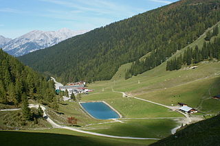
Axamer Lizum is a village and ski resort in Austria, located southwest of Innsbruck in the state of Tyrol. At the 1964 Winter Olympics, it hosted five of the six alpine skiing events: women's downhill, and men's and women's slalom and giant slalom. Men's downhill was held at Patscherkofel. Twelve years later in 1976, it hosted exactly the same alpine skiing events.
The Hoodoo Mountains are a mountain range in the northwest United States, in north central Idaho. They are part of the Clearwater Mountains and are the source of the Potlatch and Palouse rivers. Located in northeastern Latah County and southeastern Benewah County, the high point is Bald Mountain at 5,334 feet (1,626 m) above sea level. On the west slope of the northern Rocky Mountains, the Hoodoos transition into the adjoining Palouse region, to the southwest.
