Braunstone Gate Bridge

Last updated

Bowstring Bridge
Braunstone Gate Bridge.jpg
Braunstone Gate Bridge from the west showing lattice girders in 2005
Coordinates 52°37′54.2″N1°08′38.7″W / 52.631722°N 1.144083°W / 52.631722; -1.144083
Carries Great Central Railway (1899–1969)
Great Central Way (until 1997)
Crosses River Soar and Western Boulevard, Leicester
Locale Braunstone Gate
Official nameBraunstone Gate Bridge
Maintained byLeicester City Council [1]
ID number 1041 [1]
Characteristics
DesignBowstring lattice girder bridge [2] [3]
MaterialSteel
No. of spans1
Clearance below 4.80 metres (15.7 ft) [1]
History
Opened1898
Closed2009
Location
Braunstone Gate Bridge
The longer east side of the bridge. The River Soar can be seen here, passing under both the railway and Western Boulevard. Leicester-Bowstring-bridge.png
The longer east side of the bridge. The River Soar can be seen here, passing under both the railway and Western Boulevard.

The Braunstone Gate Bridge (also known as the Bowstring Bridge) was a former railway bridge carrying the Great Central Railway, and later a public footpath and cycleway, over Western Boulevard and the River Soar in Leicester, England. The bridge had been in a poor state of repair following years of neglect by the local council and it was demolished to facilitate developments for De Montfort University. The Council claimed that the costs of restoration were prohibitive.

Contents

History

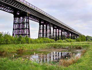
The Great Central Railway, which opened on 15 March 1899, was the last main line to be built linking the north of England with London, and crossed Leicester on a Staffordshire blue brick viaduct, over a mile and a half long and comprising 97 brick arches and 16 fine girder bridges of differing designs and dimensions, spanning various thoroughfares, the River Soar and its associated canal. This complex and costly structure began to the north of the River Soar and included two impressive bowstring lattice girder bridges. The first in Northgate Street was demolished in 1981 but the larger second, spanning Braunstone Gate, remained for a further 28 years. Known locally as the "Bowstring Bridge", it contained steel lattice girders of 178 feet 3 inches (54.33 metres) on the east side and 136 feet (41 metres) on the west, both reaching a maximum depth of 19 feet (5.8 metres) in their respective centres. The total weight of the bridge was in excess of 400 tons (407 tonnes). [4] The bridge was described as "unique" from an engineering point of view as the main supports on either side were not parallel, meaning that the two supporting girders had to be of different lengths. [5] The bridge was built by Henry Lovatt of Wolverhampton and was one of the last surviving girder structures from the Great Central's London Extension. [6]

Following the closure of this section of the Great Central on 5 May 1969, much of the railway infrastructure in Leicester was demolished. A surviving length of viaduct from Duns Lane to Glen Parva, including the Bowstring Bridge, was purchased by Leicester City Council in the 1970s for a token payment. The Council subsequently received a Manpower Services Commission grant to engage craftsmen to supervise young people painting the bridge in green and cream colours. [7] The bridge, viaduct and land nearby, including the Pump and Tap pub, were proposed to be sold to De Montfort University whose university campus adjoined the site of the Bowstring Bridge. The bridge was used to carry the Great Central Way, a footpath and cycleway following part of the disused railway line, until 1997 when the demolition of the adjoining Kirby & West dairy forced the cycleway on to the road. The section of the viaduct north of the site (including the Bowstring Bridge) went unmaintained and subsequently became derelict. [8]

In 2002, the Secretary of State for Culture, Media and Sport refused an application to list the bridge as a monument to the city's industrial heritage. [9]

Demolition

De Montfort University redevelopment

In 2005, Leicester City Council proposed to demolish the bridge to allow De Montfort University to expand its John Sandford sports hall and build a swimming pool in a £6 million development. [10] The Council claimed that the bridge had to be removed as a report revealed that it could barely support its own weight and would not last another year without major repairs. According to the report, the then 108-year-old bridge was "approaching the end of a normal life span of 120 years" and could have lasted "long into the future if only a pro-active maintenance strategy had been in place. Unfortunately, lack of funding and the demise of this section of the railway are instrumental in the extremely poor condition of the structure components. The bridge, which once carried a railway, can only carry its own weight". [8] The report estimated the costs of restoration at between £250,000 and £270,000.

Temporary reprieve

The bridge had a last-minute reprieve in July 2005 when, just before a meeting at which councillors were about to vote on its demolition, an email was sent to them by Richard Tilden-Smith of the heritage Great Central Railway urging them to postpone a decision until experts could examine the state of the bridge. He indicated that, if the bridge were saved, it might still be possible to extend his organisation's operations through Leicester, with funding possibly coming from the Heritage Lottery Fund. The cabinet agreed to give the bridge more time. [11] [12] Two weeks later, the heritage railway pulled out of talks with the Council, stating that the restoration works would be too expensive and would not fit in with the Council's timetable for the area. [13]

Application to stop-up highway

In October 2005, Leicester City Council released an engineer's report indicating that the bridge could only support its own weight and would need £775,000 to keep it intact over the next three years. Full restoration would cost £2.5 million according to the report. [14] The Council planned to demolish the bridge by Summer 2006 but had to revise its plans once it was discovered that, as the bridge was still classed as a public highway which used to carry the Great Central Way footpath, a formal stopping-up order extinguishing the highway would have to be obtained. This process would take up to a year. [15] By March 2008 the order had still not yet been granted and considerable local opposition against the plans was manifesting itself on the internet with more than 2,500 people joining a campaign on the Facebook website, and a further 1,200 signing a petition on the 10 Downing Street website. [16]

The court hearing for the stopping-up order took place 4 June 2008 at Leicester Magistrates' Court. Representatives from the Ramblers Association, the Victorian Society, the Footpath Association, Leicester Civic Society and Leicestershire Industrial History Society were present. The Council applied for the order under Section 116 of the Highways Act 1980 to have 410 metres (450 yards) of the bridge and viaduct closed, thereby avoiding the public enquiry that would have been necessary if Section 118 (also concerned with closure) had been used. [17] The hearing was adjourned until 17 June when the application was due to be heard by a district judge and a date set for a full hearing of the case. [18] Following a three-day hearing, District Judge John Stobart granted the Council's application on 9 October 2008. [19] Six local organisations and 6,000 petitioners had challenged the Council's decision. [20] A local woman was subsequently arrested after staging a 12-hour occupation protest on the bridge. [21]

Demolition

In a meeting adjourned in exclusion of the public on 3 August 2009, Leicester City Council made the decision to knock down the bowstring bridge and to sell the remaining length of viaduct on Duns Lane as well as the adjacent land to De Montfort University for an initial £1 fee. The Council would then demolish the remaining viaduct and adjoining Pump and Tap pub to make way for the university's sports centre. As part of the deal, the university would make a second payment at a later date of £250,000 followed by a final payment of £500,000. [22] The demolition of the bridge at a reported cost of £500,000 was scheduled by Leicester City Council for 21 September 2009. [23] Leicester Civic Society applied to English Heritage to have the structure listed, but this was rejected on the basis that the bridge was "not old enough or sufficiently innovative to justify preservation". [24]

Contractors began by blocking off Western Boulevard with steel fencing on 5 October 2009, and actual demolition began during the following week. The bridge itself had been entirely removed by the beginning of December. The nearby Pump and Tap pub closed its doors for the last time on 24 November 2009, and demolition began almost immediately. The section of viaduct to the north of the former bridge, behind the pub's site, was demolished in December 2010 – January 2011. Work on the new sports hall and swimming pool development started in April 2011.

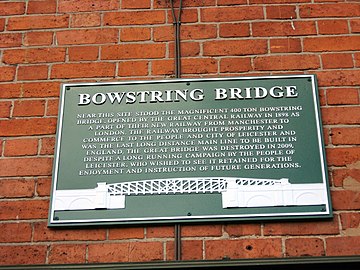
On 25 September 2010 Leicester Civic Society unveiled a memorial plaque to the former bridge on the facade of a nearby building (the Bowstring Bar).

Related Research Articles

<span class="mw-page-title-main">Leicester</span> City and unitary authority in England

Leicester is a city, unitary authority area, unparished area and the county town of Leicestershire in the East Midlands of England. It is the largest city in the East Midlands with a population of 373,399 in 2022. The greater Leicester urban area had a population of 559,017 in 2021, making it the 11th most populous in England, and the 13th most populous in the United Kingdom. A 2023 report ranked Leicester 16th out of the 50 largest UK cities on a range of economic measures, and the first of seven East Midlands cities.

<span class="mw-page-title-main">Tay Bridge</span> Railway bridge across the River Tay, Scotland

The Tay Bridge carries rail traffic across the Firth of Tay in Scotland between Dundee and the suburb of Wormit in Fife. Its span is 2.75 miles. It is the second bridge to occupy the site.
<span class="mw-page-title-main">Tinsley Viaduct</span> Road bridge in South Yorkshire, England

Tinsley Viaduct is a two-tier road bridge in Sheffield, England; it was the first of its kind in the United Kingdom. It carries the M1 and the A631 for a distance of 3,389 feet (1,033 m) over the Don Valley, from Tinsley to Wincobank, also crossing the Sheffield Canal, the Midland Main Line and the former South Yorkshire Railway line from Tinsley Junction to Rotherham Central. The Supertram route to Meadowhall runs below part of the viaduct on the trackbed of the South Yorkshire Railway line to Barnsley.
<span class="mw-page-title-main">Nottingham station</span> Transport interchange serving the city of Nottingham, England

Nottingham station, briefly known as Nottingham City and for rather longer as Nottingham Midland, is a railway station and tram stop in the city of Nottingham. It is the principal railway station of Nottingham. It is also a nodal point on the city's tram system, with a tram stop that was originally called Station Street but is now known as Nottingham Station. It is the busiest station in Nottinghamshire, the busiest in the East Midlands, and the second busiest in the Midlands after Birmingham New Street.

<span class="mw-page-title-main">Leicester City Centre</span> Human settlement in England

Leicester City Centre is Leicester's historical commercial, cultural and transport hub and is home to its central business district. Its inner core is roughly delineated by the A594, Leicester's inner ring road, although the various central campuses of the University of Leicester, De Montfort University and Leicester College are adjacent to the inner ring road and could be considered to be a continuation of the City centre. In a similar way, the Leicester Royal Infirmary precinct, New Walk business district (Southfields), the Welford Road Stadium of Leicester Tigers’ RUFC and the King Power Stadium of Leicester City to the south, and the Golden Mile to the north could also be deemed to be extensions to the central core.

<span class="mw-page-title-main">Leicester Central railway station</span> Former railway station in Leicester, England

Leicester Central was a railway station in Leicester, England. It was situated to the west of the city centre, on Great Central Street which is today just off the inner ring road. It was closed in 1969.
<span class="mw-page-title-main">Braunstone Town</span> Town and civil parish in England

Braunstone is a town and civil parish in the district of Blaby in Leicestershire, England. At the 2011 census the population of the town was 16,850.

<span class="mw-page-title-main">Windsor Railway Bridge</span> Bridge in Windsor

Windsor Railway Bridge is a wrought iron 'bow and string' bridge in Windsor, Berkshire, crossing the River Thames on the reach between Romney Lock and Boveney Lock. It carries the branch line between Slough and Windsor.
<span class="mw-page-title-main">Bennerley Viaduct</span> Railway viaduct spanning the Erewash Valley

Bennerley Viaduct is a former railway bridge, now a foot and cycle bridge, between Ilkeston, Derbyshire, and Awsworth, Nottinghamshire, in central England. It was completed in 1877 and carried the Great Northern Railway's (GNR) Derbyshire Extension over the River Erewash, which forms the county boundary, and its wide, flat valley. The engineer was Samuel Abbott, who worked under Richard Johnson, the GNR's chief engineer. The site required a bespoke design as the ground would not support a traditional masonry viaduct due to extensive coal mining. The viaduct consists of 16 spans of wrought iron, lattice truss girders, carried on 15 wrought iron piers which are not fixed to the ground but are supported by brick and ashlar bases. The viaduct is 60 feet high, 26 feet wide between the parapets, and over a quarter of a mile long. It was once part of a chain of bridges and embankments carrying the railway for around two miles across the valley but most of its supporting structures were demolished when the line closed in 1968. The only similar surviving bridge in the United Kingdom is Meldon Viaduct in Devon.

<span class="mw-page-title-main">Frog Island, Leicester</span>

Frog Island is an inner city area of Leicester, England, so named because it lies between the River Soar and the Soar Navigation. Frog Island is adjacent to the Woodgate area to the north, and Northgates to the South. The population of the island was at the 2011 census in the Abbey ward of Leicester City Council.

<span class="mw-page-title-main">Newmarket Viaduct</span> Seven-lane state highway viaduct in Auckland

The Newmarket Viaduct is a seven-lane state highway viaduct in Auckland, New Zealand. The 700 m long viaduct, which is up to 20 m high, carries the Southern Motorway over the Newmarket suburb.

<span class="mw-page-title-main">River Don Navigation</span> Waterway navigation in South Yorkshire, England

The River Don Navigation was the result of early efforts to make the River Don in South Yorkshire, England, navigable between Fishlake and Sheffield. The Dutch engineer Cornelius Vermuyden had re-routed the mouth of the river in 1626, to improve drainage, and the new works included provision for navigation, but the scheme did not solve the problem of flooding, and the Dutch River was cut in 1635 to link the new channel to Goole. The first Act of Parliament to improve navigation on the river was obtained in 1726, by a group of Cutlers based in Sheffield; the Corporation of Doncaster obtained an Act in the following year for improvements to the lower river. Locks and lock cuts were built and by 1751 the river was navigable to Tinsley.

The Charnwood Forest Railway was a branch line in Leicestershire constructed by the Charnwood Forest Company between 1881 and 1883. The branch line ran from Coalville to the town of Loughborough.

<span class="mw-page-title-main">Kennington Railway Bridge</span> Bridge in Kennington, Oxfordshire

Kennington Railway Bridge is a railway bridge over the River Thames near Kennington, Oxfordshire between Sandford Lock and Iffley Lock. It carries the freight railway branch line that serves the BMW Mini factory at Cowley. The freight railway is part of the former Wycombe Railway that linked Maidenhead and Oxford via High Wycombe and Princes Risborough.

<span class="mw-page-title-main">Brackley Central railway station</span> Former GCML Railway Station in Northamptonshire

Brackley Central was a railway station on the former Great Central Main Line which ran from Manchester Piccadilly to London Marylebone, the last main line to be built from the north of England to London.

<span class="mw-page-title-main">Tees Viaduct</span> Viaduct over the River Tees in Northern England

The A19 Tees Viaduct or Tees Flyover is a high level six-lane dual carriageway road bridge in the North East of England carrying the main A19 trunk road north–south across the River Tees.

<span class="mw-page-title-main">Aylestone Meadows</span> Nature reserve in Leicester, England, UK

Aylestone Meadows is an 8.8-hectare (22-acre) Local Nature Reserve in Leicester, England, United Kingdom. It is owned and managed by Leicester City Council.

<span class="mw-page-title-main">Narborough Road</span> Street in Leicester, United Kingdom

Narborough Road is a street in the British city of Leicester. A road since Roman times and one of the principal routes for Leicester to the M1 and M69 motorways, it is also a busy shopping street. In February 2016, it was named the UK's "most diverse" road in a research project by the London School of Economics (LSE).

<span class="mw-page-title-main">The Great Northern Railway Trail</span> Footpath in England

The Great Northern Railway Trail is a cycleway and footpath in the Bradford District of West Yorkshire, England. The path follows the route of a former railway, that of the Great Northern railway line between Bradford and Keighley that went via Queensbury and Cullingworth. The path has been designated as part of the National Cycle Route number 69.

<span class="mw-page-title-main">Midland Counties Railway Viaduct, Rugby</span>

The Midland Counties Railway viaduct is a disused railway viaduct at Rugby, Warwickshire, which crosses over both the A426 Rugby to Leicester road, and the River Avon to the north of Rugby town centre.

References

  1. 1 2 3 "Bowstring Bridge Duns Lane Leicester (Br. No. 1041) Bridge Inspection Report" (PDF). Leicester: Leicester City Council. April 2005. Archived from the original (PDF) on 3 March 2016. Retrieved 23 July 2009.
  2. Bidder, Frederick William (20 March 1900). "The Great Central Railway Extension: Northern Division". In Charles Hawksley (ed.). Minutes of proceedings of the Institution of Civil Engineers (Google books). Institution of Civil Engineers. p. 18. Retrieved 19 April 2009. At Braunstone Gate the line is carried over a road bridge and the river beneath by a single-span open-web girder bridge.
  3. Braunstone Gate Bridge, Leicestershire County Council historic photographs. Trains crossed "a 'bowstring' lattice girder bridge."
  4. "Railway's progress unstoppable". Leicester Mercury . 9 September 2005. p. 16.
  5. "Bowstring bridge is unique in many ways". Leicester Mercury. 23 July 2005. p. 30.
  6. "Braunstone Gate Bridge, Leicester". Leicester County Council. 2009. Archived from the original on 25 August 2011. Retrieved 1 September 2009.
  7. "Is varsity plan a bridge too far?". Leicester Mercury. 18 January 2008. p. 16.
  8. 1 2 Bailey, Stuart (December 2005). "Leicester Citizen: The Bowstring Bridge" (PDF). Leicester Civic Society. Retrieved 1 September 2009.
  9. "City bridge faces wrecker's ball". BBC News Online. London. 4 July 2005. Retrieved 1 September 2009.
  10. "Bridge development plan 'is cultural vandalism'". Leicester Mercury. 5 July 2005. p. 8.
  11. "Reprieved". Leicester Mercury. 13 July 2005. p. 4.
  12. "Historic bridge decision delayed". BBC News Online. 12 July 2005. Retrieved 1 September 2009.
  13. "Major blow in fight to save landmark bridge". Leicester Mercury. 22 July 2005. p. 11.
  14. "Bridge-rescue dream is fading". Leicester Mercury. 6 October 2005. p. 17.
  15. "Blunder gives bridge reprieve". Leicester Mercury. 10 January 2006. p. 13.
  16. "New hope in battle to save old bridge". Leicester Mercury. 18 March 2008. p. 8.
  17. "The battle of the bridge". Leicester Mercury. 4 June 2008. p. 10.
  18. "Show of solidarity to save pub and bridge". Leicester Mercury. 5 June 2008. p. 2.
  19. "Landmark bridge set for demolition". Leicester Mercury. 10 October 2008. Archived from the original on 12 September 2012. Retrieved 1 September 2009.
  20. "Bridge battle appeal is lost". Leicester Mercury. 9 October 2008. Archived from the original on 21 April 2013. Retrieved 1 September 2009.
  21. "Woman charged over Bowstring Bridge protest". Leicester Mercury. 11 November 2008. Archived from the original on 5 May 2013.
  22. "Secret talks seal Leicester bridge's fate". Leicester Mercury. 4 August 2009. Archived from the original on 13 September 2012. Retrieved 1 September 2009.
  23. "Date set for demolition of bridge". BBC News Online. 7 August 2009. Retrieved 1 September 2009.
  24. "Bridge fails in listed status bid". BBC News Online. 20 August 2009. Retrieved 1 September 2009.