Brazeau Bottom

Last updated
Brazeau Bottom
Brazeau Bottoms, Perry County, Missouri, Bottomland in winter.jpg
Brazeau Bottoms in winter
Coordinates: 37°40′25″N89°32′33″W / 37.67361°N 89.54250°W / 37.67361; -89.54250 (Brazeau Bottom)
Location Missouri, United States
Elevation112 m (368 ft)

The Brazeau Bottom is an alluvial floodplain, also called a 'flat', extending along the Mississippi River in Perry County, Missouri.

Contents

The Brazeau Bottom lies below the American and Bois Brule bottoms along the Mississippi River. The flat bottomland on the western bank of the Mississippi River is broken by a series of rocky bluffs, including the Red Rock Landing Conservation Area and the Seventy-Six Conservation Area, which stretch for about 10 miles. Brazeau Bottom runs for about 3 miles below this series of rocky bluffs. Brazeau Creek forms the southernmost border of the Brazeau Bottom. [1] [2] [3]

Etymology

The bottom is named for the nearby Brazeau Creek, which in turn was named for Joseph Brazeau (also spelled Obrazo) a merchant from St. Louis, Missouri in the years 1791–1799, or a member of his family. [4]

History

The area was first granted by the Spanish colonial authorities to Joseph Manning, with the first European settler in the Brazeau Bottom was George A. Hamilton, a Catholic from Maryland. Hamilton had lived in New Madrid and received permission from Spanish authorities to settle in the Brazeau Bottom in 1797. [5] Other early settlers in the Brazeau Bottom were Hinckson who settled in 1800; Joseph James who settled in 1801, under the verbal permission of the De Luziere, the colonial commandant of New Bourbon, David L. Johnson (1802), William Johnson from Kentucky who settled in 1802, Charles Duncaster, and Samuel Hinch. [5] In 1803, Joseph Fenwick and twenty other Kentucky Catholics established the Fenwick Settlement at the mouth of the Brazeau Creek. The German Saxon Lutheran immigration of 1938-39 brought numerous German settlers to the area and the establishment of Wittenberg.

Flooding

A number of floods have struck over the centuries, with the floods of 1927 and 1973 causing immense damage. The Flood of 1973 destroyed most of the businesses in Wittenberg and drove out most of the residents. [6]

Geography

The Brazeau Bottom is located in the southeast corner of Perry County, Missouri and has an elevation of 368 ft. (109 m.). [7] [8] [9] Brazeau Creek flows through Brazeau Bottom and empties into the Mississippi near Wittenberg. The 2,161 foot long Grand Tower Pipeline Bridge carries a natural gas pipeline across the Mississippi River at Wittenberg to Grand Tower, Illinois. At the southern end of Brazeau Bottom lies the rock formation Tower Rock. To the east just across the Mississippi River lies Grand Tower Island, which although lying east of the Mississippi River, nonetheless is part of Perry County, Missouri.

Communities in Brazeau Bottom

See also

Related Research Articles

<span class="mw-page-title-main">Perry County, Missouri</span> County in Missouri, United States

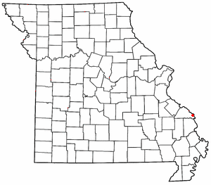
Perry County is a county located in the southeastern portion of the U.S. state of Missouri. As of the 2020 census, the population was 18,956. Its county seat is Perryville. The county was officially organized on November 16, 1820 from Ste. Genevieve County and was named after Oliver Hazard Perry, a naval hero of the War of 1812.

<span class="mw-page-title-main">Tower Rock</span> Rock formation in the Mississippi River

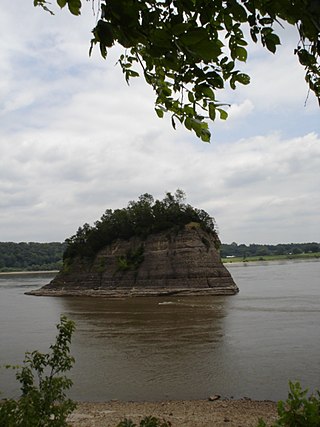
Tower Rock, also known as Grand Tower, is a rock formation and landmark island in the Mississippi River, in Brazeau Township, Perry County, Missouri, near the town of Wittenberg, Missouri, and across the river from Grand Tower, Illinois. It was listed on the National Register of Historic Places in 1970.

<span class="mw-page-title-main">Belgique, Missouri</span> Unincorporated community in Missouri, United States

Belgique is an unincorporated community in eastern Perry County, Missouri, United States. It is located approximately five miles south of Chester, Illinois, in Perry County's Bois Brule Township.

<span class="mw-page-title-main">Brazeau, Missouri</span> Unincorporated community in Missouri, United States

Brazeau is an unincorporated community in southeastern Perry County, Missouri, United States.

<span class="mw-page-title-main">Wittenberg, Missouri</span> Unincorporated community in the American state of Missouri

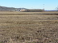
Wittenberg is an unincorporated community in Brazeau Township in eastern Perry County, Missouri, United States. It is located on the Mississippi River, 14 miles (23 km) southeast of Perryville. Wittenberg is situated in the Brazeau Bottoms on Brazeau Creek opposite Grand Tower, Illinois, and Tower Rock, the latter a landmark island in the Mississippi River.

<span class="mw-page-title-main">Menfro, Missouri</span> Unincorporated community in Missouri, United States

Menfro is an unincorporated community in northeastern Perry County, Missouri, United States. It is located 8 miles (13 km) northeast of Perryville.

<span class="mw-page-title-main">Fenwick Settlement, Missouri</span> Abandoned village in Missouri, United States

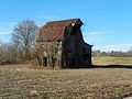
Fenwick Settlement is an abandoned village in Perry County, Missouri, United States. The community was named after the Fenwick family, who were early settlers on the left bank of the Mississippi River in the Spanish Illinois Country.

<span class="mw-page-title-main">Cinque Hommes Township, Perry County, Missouri</span> Township in the US state of Missouri

Cinque Hommes is one of the eight townships located in Perry County, Missouri, in the United States of America.

<span class="mw-page-title-main">Bois Brule Township, Perry County, Missouri</span> Township in the US state of Missouri

Bois Brûlé is one of the eight townships located in Perry County, Missouri, in the United States of America.

<span class="mw-page-title-main">Claryville, Missouri</span> Unincorporated Community in Missouri, United States

Claryville is an unincorporated community in Bois Brule Township in Perry County, Missouri, United States. It is located twelve miles northeast of Perryville, sixty-three miles south of Saint Louis, and lies adjacent to the Mississippi River.

<span class="mw-page-title-main">McBride, Missouri</span> Unincorporated community in the American state of Missouri

McBride is an unincorporated community located in Bois Brule Township in Perry County, Missouri, United States. McBride is located approximately eight miles northeast of Perryville.

<span class="mw-page-title-main">Brazeau Township, Perry County, Missouri</span> Township in the US state of Missouri

Brazeau is one of the eight townships located in Perry County, Missouri, in the United States of America.

<span class="mw-page-title-main">Bois Brule Bottom</span> Alluvial floodplain in the American state of Missouri

The Bois Brule Bottom is an alluvial floodplain in Bois Brule Township in Perry County, Missouri stretching between Bois Brule Creek to the west and the Mississippi River to the east.

<span class="mw-page-title-main">Le Grand Village Sauvage, Missouri</span> Abandoned village in Missouri, United States

Le Grand Village Sauvage, also called Chalacasa, was a Native American village located near Old Appleton in Perry County, Missouri, United States.

<span class="mw-page-title-main">Seelitz, Missouri</span> Abandoned village in Missouri, United States

Seelitz is an abandoned village in Brazeau Township in Perry County, Missouri, United States.

<span class="mw-page-title-main">Le Grand Champ Bottom</span>

Le Grand Champ is an alluvial floodplain, also called a bottom, extending along the Mississippi River in Ste. Genevieve County, Missouri.

<span class="mw-page-title-main">Cinque Hommes Creek</span> River in Missouri, United States

Cinque Hommes Creek is a tributary of the Mississippi River flowing through Perry County, Missouri.

<span class="mw-page-title-main">Apple Creek (Mississippi River tributary)</span> River in Missouri, United States

Apple Creek is a stream that rises in western Perry County, Missouri and empties into the Mississippi River, forming the boundary between Perry and Cape Girardeau counties.

<span class="mw-page-title-main">Brazeau Creek</span> River in Missouri, United States

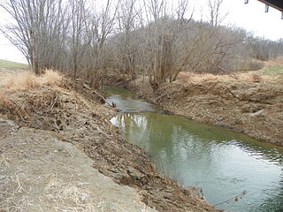
Brazeau Creek is a stream flowing through Perry County, Missouri and emptying into the Mississippi River.

<span class="mw-page-title-main">Bois Brule Creek (Cinque Hommes Creek tributary)</span> River in Missouri, United States

Bois Brule Creek is a tributary of Cinque Hommes Creek in Perry County, Missouri.

References

  1. Louis Houck (1908). "A History of Missouri: From the Earliest Explorations and Settlements Until the Admission of the State Into the Union". R. R. Donnelley & Sons Company: 385. brazeau-bottom missouri.{{cite journal}}: Cite journal requires |journal= (help)
  2. Carl Ortwin Sauer (1920). The geography of the Ozark highland of Missouri. ISBN   9780722207680.
  3. "The American Bottom". Archived from the original on 2013-12-03. Retrieved 2013-08-18.
  4. State Historical Society of Missouri: Perry County Place Names http://shs.umsystem.edu/manuscripts/ramsay/ramsay_perry.html Archived 2016-03-31 at the Wayback Machine
  5. 1 2 Louis Houck (1908). "A History of Missouri: From the Earliest Explorations and Settlements Until the Admission of the State Into the Union". R. R. Donnelley & Sons Company: 385. brazeau.{{cite journal}}: Cite journal requires |journal= (help)
  6. "Wittenberg: Nothing left but relics and memories". The Southeast Missourian newspaper website. 10 December 2005. Retrieved 24 September 2012.
  7. US Cartographic.info
  8. Mytopo.com
  9. Usa.indettaglio