Breabag

Last updated
Breabag
Hillside above the Bone Caves - geograph.org.uk - 1252813.jpg
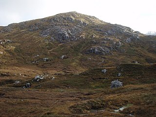
Looking up towards Breabag from the west
Highest point
Elevation 815 m (2,674 ft) [1]
Prominence 307 m (1,007 ft)
Listing Corbett, Marilyn
Geography
Location Sutherland, Scotland
Parent range Northwest Highlands
OS grid NC286157
Topo map OS Landranger 15

Breabag (815 m) is a mountain in the Northwest Highlands of Scotland, in the Assynt area of Sutherland.

The Northwest Highlands are located in the northern third of Scotland that is separated from the Grampian Mountains by the Great Glen. The region comprises Wester Ross, Assynt, Sutherland and part of Caithness. The Caledonian Canal, which extends from Loch Linnhe in the south-west, via Loch Ness to the Moray Firth in the north-east splits this area from the rest of the country. The city of Inverness and the town of Fort William serve as gateways to the region from the south.

Assynt Sparsely populated area of Sutherland on the west coast of Scotland

Assynt is a sparsely populated area in the south-west of Sutherland, lying north of Ullapool on the west coast of Scotland. Assynt is known for its landscape and its remarkable mountains, which have led to the area, along with neighbouring Coigach, being designated as the Assynt-Coigach National Scenic Area, one of 40 such areas in Scotland.

Sutherland Historic county in Scotland

Sutherland is a historic county, registration county and lieutenancy area in the Highlands of Scotland. Its county town is Dornoch. Sutherland borders Caithness and Moray Firth to the east, Ross-shire and Cromartyshire to the south and the Atlantic to the north and west. Like its southern neighbour Ross-shire, Sutherland has some of the most dramatic scenery in the whole of Europe, especially on its western fringe where the mountains meet the sea. These include high sea cliffs, and very old mountains composed of Precambrian and Cambrian rocks.

A flat-topped summit, it is usually climbed from its western flank, where the Bone Caves of Assynt are located. The nearest settlement is Inchnadamph. [2]

Inchnadamph human settlement in United Kingdom

Inchnadamph is a hamlet in Assynt, Sutherland, Scotland. The name is an anglicisation of the Gaelic name Innis nan Damh meaning 'meadow of the stags'. Assynt is a remote area with a low population density and Inchnadamph contains a few houses, a lodge and a hotel.

Related Research Articles

Old Man of Stoer

The Old Man of Stoer is a 60-metre-high (200 ft) sea stack of Torridonian sandstone in Sutherland, Scotland, close to villages of Culkein and Stoer and the nearby Stoer Head Lighthouse. It is a popular climbing route.

Ben More Assynt 998m high mountain in Scotland

Ben More Assynt is a mountain in Assynt in the far north-west of Scotland, 30 kilometres (19 mi) north-north-east of the town of Ullapool. The name translates as "big mountain of Assynt", and with a height of 998 metres (3,274 ft) it is the highest point in the county of Sutherland.

Ben Klibreck 962m high mountain in Scotland

Ben Klibreck is a Scottish mountain located in central Sutherland. It is an isolated hill, rising above a large area of moorland. The highest point, Meall nan Con, rises to 962 m (3,165 ft) and is therefore the second most northerly Munro after Ben Hope. The western side of the hill is a fairly uniform steep, heathery slope, while the eastern side has a series of large, grassy corries and has been described as having more character.

Uamh an Claonaite is the longest cave in Scotland. It consists of a series of dry passages and a series of at least six sumps which have been dived over the years.

Beinn Sgulaird 937m high mountain in Scotland

Beinn Sgulaird is a Scottish mountain located between Glen Creran and Glen Etive in the southern highlands. It has a height of 937 m (3074 ft) and is classed as a Munro. The mountain takes the form of a long ridge which runs from southwest to northeast, three kilometres of which lie above 800 m. Hillwalkers commonly traverse the ridge from north to south, as this gives the best views of the Hebrides to the west, in particular the Isle of Mull. While most walkers start from Glen Creran to the west, an ascent from Glen Etive is also possible.

An Sgarsoch

An Sgarsoch is a mountain in the Grampian Mountains of Scotland. It lies north in a very remote part of the Highlands, on the border of Aberdeenshire and Perthshire.

Ruadh-stac Beag Mountain in Scotland

Ruadh-stac Beag is a mountain in the Northwest Highlands of Scotland. An outlier of the Munro Beinn Eighe but a mountain in its own right, it is located in the Torridon Hills of Wester Ross.

A Chailleach (Fannaichs)

A' Chailleach is a mountain in the Northwest Highlands of Scotland. It lies in the Fannaichs of Wester Ross.

Garbh Chioch Mhòr

Garbh Chioch Mhor is a mountain in the Northwest Highlands of Scotland. It lies in the Lochaber region, between Loch Nevis and Loch Quoich.

Meall nan Eun (Munro)

Meall nan Eun is a mountain in the Grampian Mountains of Scotland. It is located east of Glen Etive in Argyll and Bute.

Aonach Shasuinn Mountain in the Northwest Highlands

Aonach Shasuinn is a mountain in the Northwest Highlands of Scotland. It lies in Inverness-shire, on the southern side of Glen Affric.

Meall Mor (Loch Katrine)

Meall Mor is a mountain in the Grampian Mountains of Scotland. It lies in the Stirling region, on the northern side of Loch Katrine in the Trossachs.

Carnan Cruithneachd Mountain in Scotland

Carnan Cruithneachd is a mountain in the Northwest Highlands of Scotland. It is located in the Kintail area of Ross-shire, on the southern side of Glen Elchaig.

Creag Ghuanach Mountain in Scotland

Creag Ghuanach is a mountain in the Grampian Mountains of Scotland. It is located in Lochaber, at the southern head of Loch Treig.

Creag Dhubh (Newtonmore)

Creag Dhubh is a mountain in the Grampian Mountains of Scotland. It is located in the Strathspey area of the central Highlands, above the village of Newtonmore.

Creag Dhubh (Roybridge) Scottish hill

Creag Dhubh is a hill in the Grampian Mountains of Scotland. It is located in the Lochaber region, east of Roybridge.

Bràigh nan Uamhachan

Braigh nan Uamhachan is a mountain in the Northwest Highlands of Scotland. It is located north of Glenfinnan in Lochaber.

Glas Bheinn (Kinlochleven)

Glas Bheinn is a mountain in the Grampian Mountains of Scotland, northeast of the village of Kinlochleven in Lochaber.

Glas Bheinn (Assynt) Mountain in Scotland

Glas Bheinn is a mountain in the Northwest Highlands of Scotland. It lies in the Assynt area of Sutherland, in the far north of the country.

Creach Bheinn (Loch Creran) Mountain in Scotland

Creach Bheinn is a mountain in the Grampian Mountains of Scotland. It rises above the head Loch Creran in Argyll.

References

  1. "Breabag". hill-bagging.co.uk. Retrieved 19 June 2019.
  2. "walkhighlands Breabag". walkhighlands.co.uk. Retrieved 19 June 2019.

Coordinates: 58°05′49″N4°54′32″W / 58.097°N 4.909°W / 58.097; -4.909

Geographic coordinate system Coordinate system

A geographic coordinate system is a coordinate system that enables every location on Earth to be specified by a set of numbers, letters or symbols. The coordinates are often chosen such that one of the numbers represents a vertical position and two or three of the numbers represent a horizontal position; alternatively, a geographic position may be expressed in a combined three-dimensional Cartesian vector. A common choice of coordinates is latitude, longitude and elevation. To specify a location on a plane requires a map projection.