Related Research Articles

Hesse or Hessia, officially the State of Hesse, is a state in Germany. Its capital city is Wiesbaden, and the largest urban area is Frankfurt. With an area of 21,000 square kilometers and a population of just over six million it ranks seventh and fifth respectively among the sixteen German states. Frankfurt Rhine-Main, Germany's second-largest metropolitan area, is mainly located in Hesse.

The Eder[ˈeːdɐ] is a 177-kilometre (110 mi)-long major river in Germany that begins in eastern North Rhine-Westphalia and passes in to Hesse, where it empties into the River Fulda.
Francis Lambert was a Protestant reformer, the son of a papal official at Avignon, where he was born between 1485 and 1487.
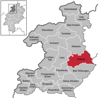
Edertal is a municipality in Waldeck-Frankenberg in northern Hesse, Germany.

Alheim is a community in Hersfeld-Rotenburg district in northeastern Hesse, Germany. It is named after nearby Alheimer Mountain. Alheim consist of 10 former souverain villages situated on both banks of the river Fulda.

Espenau is a municipality in the district of Kassel, in Hesse, Germany, composed of the districts of Espenau-Hohenkirchen and Espenau-Mönchehof. It is situated 9 kilometers north of Kassel. As of December 2019, Espenau has 5,158 inhabitants. It covers a total area of 13.59 km².
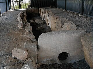
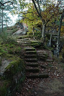
The Züschen tomb is a prehistoric burial monument, located between Lohne and Züschen, near Fritzlar, Hesse, Germany. Classified as a gallery grave or a Hessian-Westphalian stone cist, it is one of the most important megalithic monuments in Central Europe. Dating to the late 4th millennium BC, it belongs to the Late Neolithic Wartberg culture. The presence of incised carvings, comparable to prehistoric rock art elsewhere in Europe, is a striking feature of Wartberg culture tombs, known so far only from Züschen and from tomb I at Warburg.

Bergpark Wilhelmshöhe is a landscape park in Kassel, Germany. The area of the park is 2.4 square kilometres, making it the largest European hillside park, and second largest park on a hill slope in the world. Construction of the Bergpark, or "mountain park", began in 1689 at the behest of the Landgraves of Hesse-Kassel and took about 150 years. The park is open to the public today. Since 2013, it has been a UNESCO World Heritage Site.
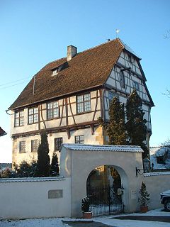
Alberweiler Castle is a small castle-like structure in the village of Alberweiler, now part of the municipality of Schemmerhofen in the state of Baden-Württemberg, Germany. It is situated on a hillside in the centre of the village. The ground and the first floor of the castle are made of stone whereas the upper storeys consist of three projecting half-timbered floors.

Altenbunslar is a small village in North Hesse, Germany.

The Riesenstein is a megalith or menhir, which is situated close to the village of Wolfershausen. It is the largest megalith in the district of Schwalm-Eder-Kreis, Hesse, Germany.
The Jestädt Jewish Cemetery is a Jewish cemetery in Jestädt, in the Municipality of Meinhard in the Werra-Meißner-Kreis in the State of Hesse of Germany. A protected cultural monument, it is one of the oldest of its kind in Hesse.
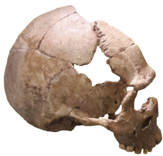
The Rhünda Skull is a fossil human skull that was found just outside the village of Rhünda in North Hesse, Germany. It is dated to the Magdalenian, about 12,000 years old.
The Wilgartaburg, also called the Wiligartaburg, Wilgartsburg or Wiligartisburg, is the heritage site of a ruined rock castle located at a height of 245 m above sea level (NN) near the German village of Wilgartswiesen in the state of Rhineland-Palatinate.

The Glisborn, or Glißborn, is a small, short stream that rises from a spring of the same name. The spring is located close to the Odenberg hill near Gudensberg in the northern Hessian district of Schwalm-Eder-Kreis. The spring is connected with numerous legends.

The land known as the Hessian Hinterland lies within the region of Middle Hesse and is concentrated around the old county of Biedenkopf, that is the western part of the present county of Marburg-Biedenkopf, as well as elements of the present-day counties of Lahn-Dill-Kreis and Waldeck-Frankenberg. Formerly it snaked its way from Bromskirchen in the north to Rodheim, in the municipality of Biebertal.

The Neckar-Odenwald Limes is a collective term for two, very different early sections of the Upper Germanic-Rhaetian Limes, a Roman defensive frontier line that may have been utilised during slightly different periods in history. The Neckar-Odenwald Limes consists of the northern Odenwald Limes (Odenwaldlimes), a cross-country limes with camps, watchtowers and palisades, which linked the River Main with the Neckar, and the adjoining southern Neckar Limes (Neckarlimes), which in earlier research was seen as a typical 'riverine limes', whereby the river replaced the function of the palisade as an approach obstacle. More recent research has thrown a different light on this way of viewing things that means may have to be relativized in future. The resulting research is ongoing.

Bad Homburg Castle is a castle and palace in the German city of Bad Homburg vor der Höhe. Originally the residence of the Landgraves of Hesse-Homburg, it was first built in the 12th century. All but the keep was demolished in 1660 by Frederick II, Landgrave of Hesse-Homburg. He replaced the old castle with a new one designed by Paul Andrich between 1680 and 1685. Its grounds and gardens were landscaped in the 18th and 19th centuries, including the addition of the Gothic House.
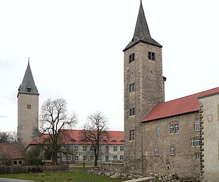
Schloss Hessen is a schloss or castle in Hessen, Saxony-Anhalt, Germany. It originated as medieval moated castle before being converted into a Renaissance princely palace in the 16th century. Its heyday was as the summer residence of the dukes of Brunswick-Lüneburg in the 17th century. It was later used as a farm house.
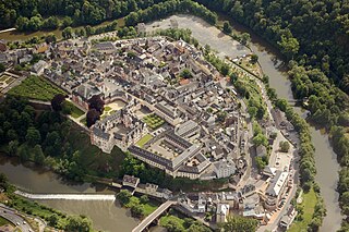
Schloss Weilburg is a Baroque schloss in Weilburg, Hesse, Germany. It is located on a spur above the river Lahn and occupies about half of the area of the Old Town of Weilburg. It contains the Hochschloss, built between 1530 and 1572, which is one of the best-preserved Renaissance palaces in Hesse. In the 1700s, the palace was expanded by John Ernst, Count of Nassau-Weilburg, and his builder, Julius Ludwig Rothweil. The buildings and gardens now belong to the Verwaltung der Staatlichen Schlösser und Gärten Hessen, and they can be visited as a museum on guided tours. Parts of the palace are venues for the music festival Weilburger Schlosskonzerte, which is named after the palace.
References
- ↑ Scharlau, Kurt (1933). "Beiträge zur geographischen Betrachtung der Wüstungen". Badische geographische Abhandlungen. Freiburg i. Br. 10: 46.
- 1 2 Landau, Georg (1858). Historisch-topographische Beschreibung der wüsten Ortschaften im Kurfürstenthum Hessen und in den großherzoglich hessischen Antheilen am Hessengaue, am Oberlahngaue und am Ittergaue. Zeitschrift des Vereins für Hessische Geschichte und Landeskunde; Supplement 7 (in German). Kassel: Fischer. p. 146 . Retrieved June 8, 2016.
- 1 2 3 4 5 "Brechelsdorf". Historischen Ortslexikon Hessen. Archived from the original on 2016-03-04. Retrieved 2015-03-08.