Felsberg, Hesse

Last updated
Felsberg
Felsberg (Hessen).jpg
Panorama of Felsberg
Wappen Felsberg (Hessen).svg
Location of Felsberg within Schwalm-Eder-Kreis district
Felsberg in HR.svgSchwarzenbornNeukirchenBorkenWabernFelsberg
Germany adm location map.svg
Red pog.svg
Felsberg
Hesse location map.svg
Red pog.svg
Felsberg
Coordinates: 51°8′N9°25′E / 51.133°N 9.417°E / 51.133; 9.417 Coordinates: 51°8′N9°25′E / 51.133°N 9.417°E / 51.133; 9.417
Country Germany
State Hesse
Admin. region Kassel
District Schwalm-Eder-Kreis
Government
   Mayor (201925) Volker Steinmetz [1] (Ind.)
Area
  Total83.27 km2 (32.15 sq mi)
Elevation
162 m (531 ft)
Population
 (2021-12-31) [2]
  Total10,638
  Density130/km2 (330/sq mi)
Time zone UTC+01:00 (CET)
  Summer (DST) UTC+02:00 (CEST)
Postal codes
34587
Dialling codes 05662, 05665 (Wolfershausen), 05683 (Lohre)
Vehicle registration HR, FZ, MEG, ZIG
Website www.felsberg.de

Felsberg is a town in the Schwalm-Eder district about 25 kilometres (16 miles) south of Kassel.

Contents

Geography

The landscape around Felsberg is marked by hills and small lakes, as well as the remains of gravel quarrying. As part of the West Hesse Depression, it lies in a sunken area that was formed by volcanic activity in the Tertiary sub-era. The change from partly basaltic hills to smooth river valleys is striking. While the river valleys are covered by fluvial sediments, fertile loess beds can be found higher up. The river Eder flows through Felsberg's municipal area. Near Gensungen lies the Heiligenberg ("Holy Mountain") with the ruins of the Heiligenburg Castle.

Constituent communities

The town consists of 15 communities: Altenbrunslar, Altenburg, Beuern, Böddiger, Gensungen, Helmshausen, Hesserode, Heßlar, Hilgershausen, Lohre, Melgershausen, Neuenbrunslar, Niedervorschütz, Rhünda and Wolfershausen together with the historic Felsberg, to which the other, formerly independent communities were amalgamated on 1 January 1974.

History

The Felsburg above Felsberg, with its soaring white tower Felsberg (Hesse) 2003-05-18 (3).jpg
The Felsburg above Felsberg, with its soaring white tower

There were settlers in the Felsberg region, as long ago as the last ice age, as witnessed by the find of the 12,000-year-old, so-called Rhünda Skull. In the 1st Century AD, the Felsberg area was inhabited by the Chatti, a Germanic tribe. The only mention of the area from this time is a report by the Roman historian Tacitus about one of Germanicus's campaigns, when in the year 15 he destroyed Mattium (probably nowadays Maden), the Chatti's capital.

In the 8th Century, the Felsberg region was part of the Frankish Empire, and this is when the town was first mentioned in documents. It was also at this time that Christian missionary work was being carried out in the area by Saint Boniface, who in 723 felled Thor's Oak near Fritzlar, about 15 km (9 mi) west of Felsberg, thereby starting the Christianization of the peoples of northern Germany.

Within the town's municipal area lie the ruins of three castles; the Felsburg, the Altenburg, in the constituent community of the same name, and the Heiligenburg Castle, above the constituent community of Gensungen, on the river Eder's opposite bank. The town is thus sometimes known as the Drei-Burgen-Stadt ("Three-Castle Town"). The castles were built in the Middle Ages for their strategic locations, during the feud between the Archbishopric of Mainz and the Landgraviate of Thuringia, or Hesse. The Heiligenburg Castle belonged to Mainz. Both the Felsburg and the Altenburg, only 2 km (1 mi) apart, are distinguished by their butter-churn towers. The Salzstraße ("Salt Road") ran through Felsberg from the river Werra, where the salt was mined, to the Rhineland.

In 1090, Felsberg was mentioned in a Mainz document under the name Velisberc, and again under the same name in 1209 in a good's directory from the Petrus Estate in Fritzlar. Felsberg's first documentary mention as a town came in 1286. The historic town core was once surrounded by an 830m-long town wall, only parts of which are preserved today.

A house of Premonstratensian canonesses, the Eppenberg Priory, was established here in about 1217, on the Eppenberg in Gensungen. This was dissolved in 1438, and rebuilt as a Carthusian monastery, Eppenberg Charterhouse, which was secularised in 1527.

In 1526, Felsberg became Evangelical under Philip the Magnanimous, after a resolution by the Homberg Synod.

The Thirty Years' War brought widespread destruction to Felsberg.

In the Second World War, Felsberg was heavily damaged by aerial bombardment and the destruction of the Edertal Dam.

Politics

The town council has 37 members. The last two municipal elections gave the following results:

Summary of Felsberg election results
20062011
PartiesVotes %SeatsVotes %Seats
Social Democratic Party (SPD) 53.92050.319
Christian Democratic Union (CDU) 23.8921.68
Alliance 90/The Greens 6.4214.55
Free Democratic Party (FDP) 5.724.92
Free Voters (FWG) 5.024.42
Die Freien Bürger (DFB)5.224.41
Total1003710037
Election 2011 Felsberg
SPD
50.3%
CDU
21.6%
B'90/GRÜNE
14.5%
FDP
4.9%
FWG
4.4%
DFB
4.4%

The town executive (Magistrat) consists of 14 councillors and the mayor. Of those, 8 seats are held by the SPD, 3 by the CDU and one seat each by the Alliance 90/The Greens, the FDP and the FWG.

The last three elected mayors were:

Mayors of Felsberg
Date electedNamePartyPercentage of votes
28 October 2001Klaus Stiegel SPD 85.2%
1 April 2008Volker SteinmetzIndependent67.6%
3 November 2013Volker SteinmetzIndependent73.6%

Klaus Stiegel was mayor of Felsberg for 24 years.

Coat of arms

The town's civic coat of arms has been known since 1570, when it was displayed at the Schloss Rotenburg (a stately home in Rotenburg an der Fulda, built by Landgrave Ludwig II in 1540). It was also published in the Hessisches Wappenbuch ("Hessian Arms Book") by Wilhelm Wessel in 1633.

Wappen Felsberg (Hessen).svg

Heraldically, the arms might be described thus: Party per pale gules and argent, thereover a bend sinister vert, therein three trefoils argent.

Town partnerships

Felsberg is twinned with the following towns:

It also has friendship agreements with these places:

Personalities

Related Research Articles

Schwalm-Eder-Kreis is a Kreis (district) in the north of Hesse, Germany. Neighbouring districts are Kassel, Werra-Meißner, Hersfeld-Rotenburg, Vogelsberg, Marburg-Biedenkopf, and Waldeck-Frankenberg.

<span class="mw-page-title-main">Fritzlar</span> Town in Hesse, Germany

Fritzlar is a small town in the Schwalm-Eder district in northern Hesse, Germany, 160 km (99 mi) north of Frankfurt, with a storied history.

<span class="mw-page-title-main">Battenberg (Eder)</span> Town in Hesse, Germany

Battenberg (Eder) is a small town in Waldeck-Frankenberg district, the state of Hesse, Germany. The town is noted for giving its name to the Battenberg family, a morganatic branch of the ruling House of Hesse-Darmstadt, and through it, the name Mountbatten used by members of the British royal family, a literal translation of Battenberg.

<span class="mw-page-title-main">Gudensberg</span> Town in Hesse, Germany

Gudensberg is a small town in northern Hesse, Germany. Since the municipal reform in 1974, the nearby villages of Deute, Dissen, Dorla, Gleichen, Maden and Obervorschütz have become parts of the municipality.

<span class="mw-page-title-main">Melsungen</span> Town in Hesse, Germany

Melsungen is a small climatic spa town in the Schwalm-Eder district in northern Hesse, Germany. In 1987, the town hosted the 27th Hessentag state festival.

<span class="mw-page-title-main">Niedenstein</span> Town in Hesse, Germany

Niedenstein is a small town and an officially recognized climatic spa in the Schwalm-Eder district in northern Hesse, Germany.

<span class="mw-page-title-main">Oberaula</span> Municipality in Hesse, Germany

Oberaula is a municipality in the Schwalm-Eder district in Hesse, Germany.

<span class="mw-page-title-main">Frankenau</span> Town in Hesse, Germany

Frankenau is a small town in Waldeck-Frankenberg district in Hesse, Germany.

<span class="mw-page-title-main">Edertal</span> Municipality in Hesse, Germany

Edertal is a municipality in Waldeck-Frankenberg in northern Hesse, Germany.

<span class="mw-page-title-main">Vöhl</span> Municipality in Hesse, Germany

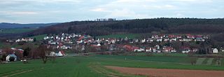
Vöhl is a municipality in Waldeck-Frankenberg in Hesse, Germany, not far southwest of Kassel.

<span class="mw-page-title-main">Philippsthal (Werra)</span> Municipality in Hesse, Germany

Philippsthal (Werra) is a market community in Hersfeld-Rotenburg district in eastern Hesse, Germany, right at the boundary with Thuringia.

<span class="mw-page-title-main">Alheim</span> Municipality in Hesse, Germany

Alheim is a municipality in Hersfeld-Rotenburg district in northeastern Hesse, Germany. It is named after nearby Alheimer Mountain. Alheim consist of 10 former souverain villages situated on both banks of the river Fulda.

<span class="mw-page-title-main">Breitenbach am Herzberg</span> Municipality in Hesse, Germany

Breitenbach am Herzberg is a municipality in southwesternmost Hersfeld-Rotenburg district in eastern Hesse, Germany.

<span class="mw-page-title-main">Neuenstein, Hesse</span> Municipality in Hesse, Germany

Neuenstein is a municipality in the Hersfeld-Rotenburg district of northeastern Hesse, Germany.

<span class="mw-page-title-main">Hohenroda</span> Municipality in Hesse, Germany

Hohenroda is a municipality in Hersfeld-Rotenburg district in eastern Hesse, Germany lying right on the boundary with Thuringia.

<span class="mw-page-title-main">Cornberg</span> Municipality in Hesse, Germany

Cornberg is a municipality in Hersfeld-Rotenburg district in northeastern Hesse, Germany. It is the district's smallest municipality.

<span class="mw-page-title-main">Ludwigsau</span> Municipality in Hesse, Germany

Ludwigsau is a municipality in Hersfeld-Rotenburg district in northeastern Hesse, Germany. With an area of 112 km² it is Hesse's biggest community by land area.

<span class="mw-page-title-main">Nentershausen, Hesse</span> Municipality in Hesse, Germany

Nentershausen is a municipality in Hersfeld-Rotenburg district in northeastern Hesse, Germany.

<span class="mw-page-title-main">Wolfershausen</span> Part of Felsberg in Hesse, Germany

Wolfershausen is one of the sixteen constituent communities that form the town of Felsberg in Schwalm-Eder-Kreis, North Hesse, Germany.

<span class="mw-page-title-main">Heiligenburg Castle</span> Historic site

Heiligenburg Castle is a castle on the hill of Heiligenberg in the district of Schwalm-Eder-Kreis, Hesse, Germany.

References

  1. "Ergebnisse der letzten Direktwahl aller hessischen Landkreise und Gemeinden" (XLS) (in German). Hessisches Statistisches Landesamt. 5 September 2022.
  2. "Die Bevölkerung der hessischen Gemeinden am 31. Dezember 2021" (PDF) (in German). Hessisches Statistisches Landesamt. June 2022.