Malsfeld

Last updated
Malsfeld
Wappen Malsfeld.svg
Location of Malsfeld within Schwalm-Eder-Kreis district
Malsfeld in HR.svgSchwarzenbornNeukirchenBorkenWabernFelsberg
Germany adm location map.svg
Red pog.svg
Malsfeld
Hesse location map.svg
Red pog.svg
Malsfeld
Coordinates: 51°05′N09°32′E / 51.083°N 9.533°E / 51.083; 9.533 Coordinates: 51°05′N09°32′E / 51.083°N 9.533°E / 51.083; 9.533
Country Germany
State Hesse
Admin. region Kassel
District Schwalm-Eder-Kreis
Government
   Mayor (202127) Michael Hanke [1] (SPD)
Area
  Total34.49 km2 (13.32 sq mi)
Elevation
192 m (630 ft)
Population
 (2020-12-31) [2]
  Total3,889
  Density110/km2 (290/sq mi)
Time zone UTC+01:00 (CET)
  Summer (DST) UTC+02:00 (CEST)
Postal codes
34323
Dialling codes 05661
Vehicle registration HR
Website www.malsfeld.de

Malsfeld is a municipality in the Schwalm-Eder district in Hesse, Germany, on the river Fulda.

Contents

The community consists of the centres of Beiseförth, Dagobertshausen, Elfershausen, Mosheim, Malsfeld, Ostheim and Sipperhausen.

The community was once a railway hub on the Kassel–Bebra and Treysa–Eschwege lines. It has an interchange on the Autobahn A 7.

Constituent communities

Beiseförth

Although it had its first documentary mention in 1348 as "Beysenvorte", the community is believed to date back to the 8th century. In 1603, "Beysenfort" became a fief of Philip von Scholley.

Until about 1870, shipping on the river Fulda with Kassel und Hersfeld was as important a source of income as linen weaving and later basketry.

Among the sights to see are the Schiffhaus ("Ship House") where the Beise empties into the Fulda, and the Korbmachermuseum ("Basket Maker's Museum").

Dagobertshausen

The way into Dagobertshausen, "fortress church" in the background Dagobertshausen, Malsfeld.jpg
The way into Dagobertshausen, "fortress church" in the background

A legend holds that the name Dagobertshausen comes from Frankish King Dagobert I, who beat the Wends here in 631. Officially, though, the name has only been used since 1747, until which time the village had been known as "Dabelshusen", "Dageboldishus" or "Taboldshusen".

Dagobert I is also said to have endowed a church, on whose site now stands the "fortress church", built in the 12th or 13th century.

Elfershausen

Elfershausen had its first documentary mention in 1253 when the whole village was donated to the Breitenau monastery by the Count of Felsberg. After the Reformation, the village passed into the Landgraves' ownership. Beginning in 1770, the "Domäne Elfershausen" even included parts of Dagobertshausen; it was finally dissolved only in 1971 when it was amalgamated with Malsfeld in what would turn out to be the beginning of the later "Greater Community of Malsfeld", which was formed as part of municipal reforms.

The Sälzerweg, a commercial road between Leipzig and Frankfurt runs north of Elfershausen. Elfershausen's inhabitants worked mainly in agriculture at one time.

Mosheim

The first mention of Mosheim (as "Mazheim") can be found in the Breviarium Lulli between 775 and 786. In the Codex Eberhardi, Mosheim is mentioned as a donation to the Fulda monastery (between 802 and 817). Over time, the village's name has varied somewhat (1266 Masheim, 1376 Moßheym, 1428 Maßheim, 1597 Maaßheimb, 1600 Mosheimb). In 1324, Mosheim came under Hessian overlordship under Konrad von Hebel. Between 1219 and 1450, Mosheim had a local noble family. In 1194, Mosheim's church was mentioned as a chapel. A small church built about 1500 was partly destroyed in the Thirty Years' War, expanded in 1752, and remodelled in 1969

Ostheim

Ostheim had its first documentary mention between 1145 and 1159. Basalt was once quarried here, and brown coal was also mined.

Sipperhausen

Sipperhausen lies between Homberg and Melsungen. It had its first documentary mention in 943 as the abandoned village of "Swidburg", and then in 1142 as "Swipergehusen". The community also includes the settlement of Bubenrode, from 1377 a knight's manor of the Malsburg noble family.

Sightseeing

Specialities

Partnerships

Malsfeld maintains partnerships with the following places:

Related Research Articles

<span class="mw-page-title-main">Wartenberg, Hesse</span> Municipality in Hesse, Germany

Wartenberg is a municipality in the Vogelsbergkreis in Hesse, Germany.

<span class="mw-page-title-main">Bebra</span> Town in Hesse, Germany

Bebra is a small town in Hersfeld-Rotenburg district in northeastern Hesse, Germany.

<span class="mw-page-title-main">Edermünde</span> Municipality in Hesse, Germany

Edermünde is a municipality in northern Hesse, Germany.

<span class="mw-page-title-main">Frielendorf</span> Municipality in Hesse, Germany

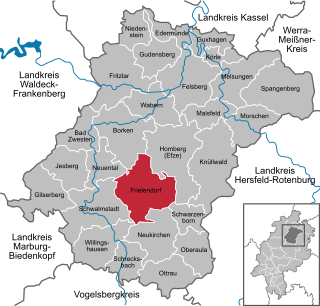
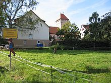
Frielendorf is a municipality in the Schwalm-Eder district, Hesse, Germany.

<span class="mw-page-title-main">Körle</span> Municipality in Hesse, Germany

Körle is a community in the Schwalm-Eder district in Hesse, Germany. It lies about 20 km south of Kassel near the turn-off for Guxhagen on Autobahn A 7.

<span class="mw-page-title-main">Morschen</span> Municipality in Hesse, Germany

Morschen is a municipality in the Schwalm-Eder district in Hesse, Germany.

<span class="mw-page-title-main">Lohfelden</span> Municipality in Hesse, Germany

Lohfelden is a municipality in the district of Kassel, in Hesse, Germany. It is situated 6 km southeast of Kassel. It has three parts Crumbach, Ochsenhausen and the former independent Vollmarshausen.

<span class="mw-page-title-main">Antrifttal</span> Municipality in Hesse, Germany

Antrifttal is a municipality in the Vogelsbergkreis in Hesse, Germany.

<span class="mw-page-title-main">Grebenhain</span> Municipality in Hesse, Germany

Grebenhain is a municipality in the Vogelsbergkreis in Hesse, Germany.

<span class="mw-page-title-main">Immenhausen</span> Town in Hesse, Germany

Immenhausen is a town in the district of Kassel, in Hesse, Germany. It is located 12 km north of Kassel on the German Timber-Frame Road. The town has 7,098 inhabitants as of July 2020, including the northern village of Mariendorf and eastern village of Holzhausen.

<span class="mw-page-title-main">Sontra</span> Town in Hesse, Germany

Sontra is a small town in the Werra-Meißner-Kreis in northeastern Hesse, Germany.

<span class="mw-page-title-main">Meißner, Hesse</span> Municipality in Hesse, Germany

Meißner is a municipality in the Werra-Meißner-Kreis in Hesse, Germany.

<span class="mw-page-title-main">Alheim</span> Municipality in Hesse, Germany

Alheim is a municipality in Hersfeld-Rotenburg district in northeastern Hesse, Germany. It is named after nearby Alheimer Mountain. Alheim consist of 10 former souverain villages situated on both banks of the river Fulda.

<span class="mw-page-title-main">Wildeck</span> Municipality in Hesse, Germany

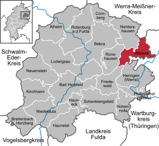
Wildeck is a municipality in Hersfeld-Rotenburg district in northeastern Hesse, Germany lying right at the boundary with Thuringia, 54 km southeast of Kassel.

<span class="mw-page-title-main">Neuenstein, Hesse</span> Municipality in Hesse, Germany

Neuenstein is a community in Hersfeld-Rotenburg district in northeastern Hesse, Germany.

<span class="mw-page-title-main">Hauneck</span> Municipality in Hesse, Germany

Hauneck is a community in Hersfeld-Rotenburg district in eastern Hesse, Germany.

<span class="mw-page-title-main">Hohenroda</span> Municipality in Hesse, Germany

Hohenroda is a municipality in Hersfeld-Rotenburg district in eastern Hesse, Germany lying right on the boundary with Thuringia.

<span class="mw-page-title-main">Cornberg</span> Municipality in Hesse, Germany

Cornberg is a municipality in Hersfeld-Rotenburg district in northeastern Hesse, Germany. It is the district's smallest municipality.

<span class="mw-page-title-main">Friedewald, Hesse</span> Municipality in Hesse, Germany

Friedewald is a municipality in Hersfeld-Rotenburg district in eastern Hesse, Germany, directly east of Bad Hersfeld.

<span class="mw-page-title-main">Espenau</span> Municipality in Hesse, Germany

Espenau is a municipality in the district of Kassel, in Hesse, Germany. It is composed of two districts the Espenau-Hohenkirchen, and the Espenau-Mönchehof both are situated 9 kilometers north of Kassel. As of December 2019, Espenau has 5,158 inhabitants. It covers a total area of 13.59 km².

References

  1. "Ergebnisse der letzten Direktwahl aller hessischen Landkreise und Gemeinden" (XLS) (in German). Hessisches Statistisches Landesamt. 5 September 2022.
  2. "Bevölkerung in Hessen am 31.12.2020 nach Gemeinden". Hessisches Statistisches Landesamt (in German). June 2021.