Spangenberg

Last updated
Spangenberg
Wappen Spangenberg (Hessen).png
Location of Spangenberg within Schwalm-Eder-Kreis district
Spangenberg in HR.svgSchwarzenbornNeukirchenBorkenWabernFelsberg
Germany adm location map.svg
Red pog.svg
Spangenberg
Hesse location map.svg
Red pog.svg
Spangenberg
Coordinates: 51°7′N9°40′E / 51.117°N 9.667°E / 51.117; 9.667
Country Germany
State Hesse
Admin. region Kassel
District Schwalm-Eder-Kreis
Subdivisions13 Stadtteile
Government
   Mayor (202127) Andreas Rehm [1]
Area
  Total97.7 km2 (37.7 sq mi)
Highest elevation
530 m (1,740 ft)
Lowest elevation
200 m (700 ft)
Population
 (2022-12-31) [2]
  Total6,122
  Density63/km2 (160/sq mi)
Time zone UTC+01:00 (CET)
  Summer (DST) UTC+02:00 (CEST)
Postal codes
34286
Dialling codes 05663
Vehicle registration HR
Website www.spangenberg.de

Spangenberg is a small town in northeastern Hesse, Germany.

Contents

Geography

Spangenberg lies in the Schwalm-Eder district some 35 km (22 mi) southeast of Kassel, west of the Stölzinger Gebirge, a low mountain range. Spangenberg is the demographic centrepoint of Germany.

History

The town of Spangenberg had its first documented mention in 1261, at about the time when the Treffurt family ruled Spangenberg.

Historic sights

Schloss Spangenberg Schloss-Spangenberg Germany October-2010 Front-View.jpg
Schloss Spangenberg

The town is known best of all for Spangenberg Castle, built in 1253 and the town's landmark. Also worth seeing are the half-timbered buildings in the Old Town and the remains of the town's old wall, several of whose towers are still standing.

In World War II, Spangenberg Castle was used as a prisoner of war camp, Oflag IX-A/H. There was a second camp a few miles to the south - Oflag IX-A-Z. [3]

Coat of arms

Spangenberg's civic coat of arms is based on the town's oldest known seal from 1317. The object on the viewer's right (heraldically speaking, the left, as the shield is considered from the point of view of the bearer) side is a kind of fossilized plant locally known as a Spange (also German for "brooch" or "clip"), the town's namesake. The item on the viewer's left (heraldic right) is half of a wheel. Wheels are common in German civic heraldry, usually indicating some connection to the Archbishopric of Mainz, whose arms include wheels in honor of St. Willigis. The current colours – red and gold – have been in use since 1621. [4]

Constituent communities

In alphabetical order, these are Bergheim, Bischofferode, Elbersdorf, Herlefeld, Kaltenbach, Landefeld, Metzebach, Mörshausen, Nausis, Pfieffe, Schnellrode, Vockerode-Dinkelberg and Weidelbach.

Partnerships

Spangenberg maintains partnerships with the following places:

Famous people

Margarethe von der Saale Margarethe von der Saale 2.jpg
Margarethe von der Saale

Related Research Articles

<span class="mw-page-title-main">Rauschenberg, Hesse</span> Town in Hesse, Germany

Rauschenberg is a town in the north of Marburg-Biedenkopf district in Hesse, Germany.

<span class="mw-page-title-main">Felsberg, Hesse</span> Town in Hesse, Germany

Felsberg is a town in the Schwalm-Eder district about 25 kilometres south of Kassel.

<span class="mw-page-title-main">Schwalmstadt</span> Town in Hesse, Germany

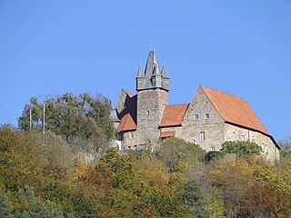
Schwalmstadt is the largest town in the Schwalm-Eder district, in northern Hesse, Germany. It was established only in 1970 with the amalgamation of the towns of Treysa and Ziegenhain together with some outlying villages to form the town of Schwalmstadt.

<span class="mw-page-title-main">Babenhausen, Hesse</span> Town in Hesse, Germany

Babenhausen is a town in the Darmstadt-Dieburg district, in Hesse, Germany.

<span class="mw-page-title-main">Melsungen</span> Town in Hesse, Germany

Melsungen is a small climatic spa town in the Schwalm-Eder district in northern Hesse, Germany. In 1987, the town hosted the 27th Hessentag state festival.

<span class="mw-page-title-main">Rotenburg an der Fulda</span> Town in Hesse, Germany

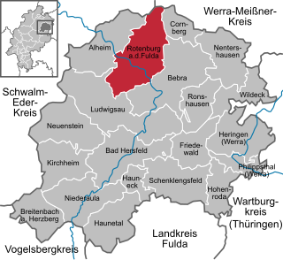
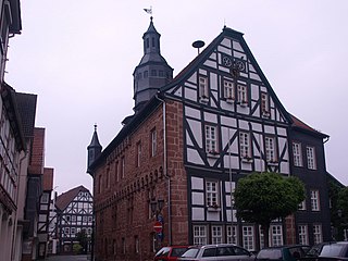
Rotenburg an der Fulda is a town in Hersfeld-Rotenburg district in northeastern Hesse, Germany lying, as the name says, on the river Fulda.

<span class="mw-page-title-main">Oberaula</span> Municipality in Hesse, Germany

Oberaula is a municipality in the Schwalm-Eder district in Hesse, Germany.

<span class="mw-page-title-main">Schwarzenborn, Hesse</span> Town in Hesse, Germany

Schwarzenborn is the smallest town in Hesse, Germany. It lies in the Schwalm-Eder district some 13.5 km from Homberg in the Knüll. Through the constituent community of Grebenhagen flows the river Efze. The town consists of the two centres of Grebenhagen and Schwarzenborn.

<span class="mw-page-title-main">Wabern, Hesse</span> Municipality in Hesse, Germany

Wabern is a municipality in the Schwalm-Eder district in northern Hesse, Germany. It lies on the Main-Weser Railway between Kassel and Frankfurt. From Wabern, the Edersee Railway runs to Bad Wildungen.

<span class="mw-page-title-main">Romrod</span> Town in Hesse, Germany

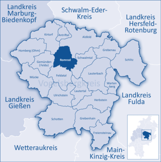
Romrod is a small town in the Vogelsbergkreis in central Hesse, Germany.

<span class="mw-page-title-main">Schlitz, Hesse</span> Town in Hesse, Germany

Schlitz is a small town in the Vogelsbergkreis in eastern Hesse, Germany.

<span class="mw-page-title-main">Braunfels</span> Town in Hesse, Germany

Braunfels is a town in the Lahn-Dill-Kreis in Hesse, Germany. It is located on the German Timber-Frame Road.

<span class="mw-page-title-main">Bad Karlshafen</span> Town in Hesse, Germany

Bad Karlshafen is a baroque, thermal salt spa town in the district of Kassel, in Hesse, Germany. It has 2300 inhabitants in the main ward of Bad Karlshafen, and a further 1900 in the medieval village of Helmarshausen. It is situated at the confluence of the Diemel and Weser rivers, 15 km south of Höxter, and 37 km north of Kassel.

<span class="mw-page-title-main">Frankenau</span> Town in Hesse, Germany

Frankenau is a small town in Waldeck-Frankenberg district in Hesse, Germany.

<span class="mw-page-title-main">Volkmarsen</span> Town in Hesse, Germany

Volkmarsen[ˈfɔlkˌmaʁzn̩] is a small town in Waldeck-Frankenberg district in northern Hesse, Germany. It is home to 6840 residents.

<span class="mw-page-title-main">Vöhl</span> Municipality in Hesse, Germany

Vöhl is a municipality in Waldeck-Frankenberg in Hesse, Germany, not far southwest of Kassel.

<span class="mw-page-title-main">Philippsthal (Werra)</span> Municipality in Hesse, Germany

Philippsthal (Werra) is a market community in Hersfeld-Rotenburg district in eastern Hesse, Germany, right at the boundary with Thuringia.

<span class="mw-page-title-main">Cornberg</span> Municipality in Hesse, Germany

Cornberg is a municipality in Hersfeld-Rotenburg district in northeastern Hesse, Germany. It is the district's smallest municipality.

<span class="mw-page-title-main">Calden</span> Municipality in Hesse, Germany

Calden is a municipality in the district of Kassel in Hesse, Germany. It is located 12 km northwest of the city of Kassel, and the Kassel Airport is situated near Calden.

<span class="mw-page-title-main">Spangenberg Castle (Hesse)</span>

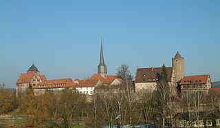
Spangenberg Castle is a schloss above the small German town of Spangenberg in the North Hesse county of Schwalm-Eder-Kreis. The originally Gothic building was first a medieval fortified castle, then a fortress, hunting lodge, prison, forestry school and is now a hotel and restaurant.

References

  1. "Ergebnisse der letzten Direktwahl aller hessischen Landkreise und Gemeinden" (XLS) (in German). Hessisches Statistisches Landesamt. 5 September 2022.
  2. "Bevölkerung in Hessen am 31.12.2022 nach Gemeinden" (XLS) (in German). Hessisches Statistisches Landesamt. June 2023.
  3. "British Prisoners of war in European Camps during the Second World War 1939-1945". www.forces-war-records.co.uk. Retrieved 2020-11-29.
  4. Heraldry of the World