Schrecksbach

Last updated
Schrecksbach
Wappen Schrecksbach.png
Location of Schrecksbach within Schwalm-Eder-Kreis district
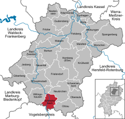
Schrecksbach in HR.svgSchwarzenbornNeukirchenBorkenWabernFelsberg
Germany adm location map.svg
Red pog.svg
Schrecksbach
Hesse location map.svg
Red pog.svg
Schrecksbach
Coordinates: 50°50′N9°17′E / 50.833°N 9.283°E / 50.833; 9.283
Country Germany
State Hesse
Admin. region Kassel
District Schwalm-Eder-Kreis
Government
   Mayor (202329) Daniel Helwig [1] (SPD)
Area
  Total36.61 km2 (14.14 sq mi)
Elevation
280 m (920 ft)
Population
 (2022-12-31) [2]
  Total2,981
  Density81/km2 (210/sq mi)
Time zone UTC+01:00 (CET)
  Summer (DST) UTC+02:00 (CEST)
Postal codes
34637
Dialling codes 06698
Vehicle registration HR
Website www.schrecksbach.de

Schrecksbach is a municipality in the Schwalm-Eder district in Hesse State, Germany.

Contents

Geography

Location

Schrecksbach lies in the southern part of Schwalm-Eder on the River Schwalm, and forms the border with the Vogelsbergkreis.

Constituent communities

The following centres belong to the greater community::

  • Hof Röllhausen
  • Holzburg
  • Röllshausen
  • Salmshausen
  • Schönberg
  • Schrecksbach
  • Trockenbach

History

Schrecksbach is a very old place that was mentioned in one of Charlemagne's documents as "Screggesbaha am Sualmanahafluß" as early as 782.

The community itself was first mentioned in 1223.

On 31 October 1806, Napoleon's army overran the country. Elector William I fled and was unseated. At this time, Schrecksbach was occupied by enemy (ie French) troops, suffering heavily as a result.

Politics

Municipal council

Municipal council is made up of 23 members.

(as of municipal elections held on 26 March 2006)

Economy and infrastructure

Transport

The community is connected to the buslines through the railway stations at Schwalmstadt-Treysa and Alsfeld.

Related Research Articles

<span class="mw-page-title-main">Wohratal</span> Municipality in Hesse, Germany

Wohratal is a municipality in Marburg-Biedenkopf district in Hessen, Germany.

<span class="mw-page-title-main">Bad Zwesten</span> Municipality in Hesse, Germany

Bad Zwesten is a municipality in the Schwalm-Eder district of Hesse, Germany.

<span class="mw-page-title-main">Edermünde</span> Municipality in Hesse, Germany

Edermünde is a municipality in northern Hesse, Germany.

<span class="mw-page-title-main">Frielendorf</span> Municipality in Hesse, Germany

Frielendorf is a municipality in the Schwalm-Eder district, Hesse, Germany.

<span class="mw-page-title-main">Jesberg</span> Municipality in Hesse, Germany

Jesberg is a municipality in the Schwalm-Eder district in Hesse, Germany.

<span class="mw-page-title-main">Knüllwald</span> Municipality in Hesse, Germany

Knüllwald is a municipality in the Schwalm-Eder district in Hesse, Germany.

<span class="mw-page-title-main">Körle</span> Municipality in Hesse, Germany

Körle is a municipality in the Schwalm-Eder district in Hesse, Germany. It lies about 20 km south of Kassel near the turn-off for Guxhagen on Autobahn A 7.

<span class="mw-page-title-main">Neuental</span> Municipality in Hesse, Germany

Neuental is a municipality in the Schwalm-Eder district in Hesse, Germany.

<span class="mw-page-title-main">Oberaula</span> Municipality in Hesse, Germany

Oberaula is a municipality in the Schwalm-Eder district in Hesse, Germany.

<span class="mw-page-title-main">Ottrau</span> Municipality in Hesse, Germany

Ottrau is a municipality in the Schwalm-Eder-Kreis in Hesse, Germany.

<span class="mw-page-title-main">Schwarzenborn, Hesse</span> Town in Hesse, Germany

Schwarzenborn is the smallest town in Hesse, Germany. It lies in the Schwalm-Eder district some 13.5 km from Homberg in the Knüll. Through the constituent community of Grebenhagen flows the river Efze. The town consists of the two centres of Grebenhagen and Schwarzenborn.

<span class="mw-page-title-main">Willingshausen</span> Municipality in Hesse, Germany

Willingshausen is a municipality in the Schwalm-Eder district in Hesse, Germany.

<span class="mw-page-title-main">Herbstein</span> Town in Hesse, Germany

Herbstein is a small town in the Vogelsbergkreis in Hesse, Germany.

<span class="mw-page-title-main">Lautertal (Vogelsberg)</span> Municipality in Hesse, Germany

Lautertal is a municipality in the Vogelsbergkreis in Hesse, Germany.

<span class="mw-page-title-main">Schwalmtal, Hesse</span> Municipality in Hesse, Germany

Schwalmtal is a municipality in the Vogelsbergkreis in Hesse, Germany.

<span class="mw-page-title-main">Diemelsee (municipality)</span> Municipality in Hesse, Germany

Diemelsee is a municipality in Waldeck-Frankenberg in northwest Hesse, Germany, and is part of the low mountain region called Upland. Adorf is the seat of this municipality.

<span class="mw-page-title-main">Edertal</span> Municipality in Hesse, Germany

Edertal is a municipality in Waldeck-Frankenberg in northern Hesse, Germany.

<span class="mw-page-title-main">Haina</span> Municipality in Hesse, Germany

Haina (Kloster) is a municipality in Waldeck-Frankenberg in northwest Hesse, Germany.

<span class="mw-page-title-main">Biebesheim am Rhein</span> Municipality in Hesse, Germany

Biebesheim am Rhein is a municipality in Groß-Gerau district in Hesse, Germany.

<span class="mw-page-title-main">Alheim</span> Municipality in Hesse, Germany

Alheim is a municipality in Hersfeld-Rotenburg district in northeastern Hesse, Germany. It is named after nearby Alheimer Mountain. Alheim consist of 10 former souverain villages situated on both banks of the river Fulda.

References

  1. "Ergebnisse der jeweils letzten Direktwahl von Landrätinnen und Landräte sowie (Ober-)Bürgermeisterinnen und (Ober-)Bürgermeister in Hessen" (XLS) (in German). Hessisches Statistisches Landesamt. 21 May 2024.
  2. "Bevölkerung in Hessen am 31.12.2022 nach Gemeinden" (XLS) (in German). Hessisches Statistisches Landesamt. June 2023.