History
The earliest archaeological finds for the area are two menhirs from 1180 BC.
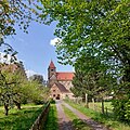
A settlement developed around the monastery in Breitenau, which was founded in 1119 and dissolved in 1527. The church is still in use as a church, other buildings were repurposed through the centuries. Changing uses and repeated damages by war and conflicts led to alterations and rebuilding of the area through the centuries.
The village of Guxhagen itself was first documented in 1352 under the name Kukushayn. Upon the closing of the monastery in 1527, the village was recognised as independent.
The village suffered damages from the 30 Years War in 1626, and again in the 7 Years war between 1756 and 1763.
From 1845 till 1848, the first railway from Kassel to Bebra was built, bringing a direct connection from Guxhagen to the wider area. This allowed for economic growth, and led to an increase of population in Guxhagen.
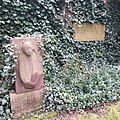
Between 1933 and 1945, the old monastery was used as a Concentration Camp. Upon the arrival of UA-american troops in 1945, 28 prisoners were killed by Gestapo. A memorial and a museum exhibit serve as reminders.
After the 2nd World War, bridges and streets were rebuilt. The new school was opened in 1964.
In the mid of the 20th century, an Autobahn connection was built.
Jewish life in Guxhagen
From 1664-1941, there were Jewish families living in Guxhagen who formed their own community and built a synagogue and school. After the events at the Kristallnacht pogrom of 1938, the number of community members decreased to 64 in 1939 (3.3% of 1,919). In connection with the November pogrom, eleven Jewish men and a boy were arrested and brought to Breitenau concentration camp. After this event, many Jews left. During The Holocaust the rest of Jews were deported to concentration camps and most of them died. Today, the old synagogue is used for cultural and memorial events.
This page is based on this
Wikipedia article Text is available under the
CC BY-SA 4.0 license; additional terms may apply.
Images, videos and audio are available under their respective licenses.