Wolfershausen

Last updated

Wolfershausen
Part of Felsberg
Wolfershausen Wappen cutout.gif
Location of Wolfershausen
Wolfershausen
Germany adm location map.svg
Red pog.svg
Wolfershausen
Hesse location map.svg
Red pog.svg
Wolfershausen
Coordinates: 51°10′53″N9°26′39″E / 51.18139°N 9.44417°E / 51.18139; 9.44417 Coordinates: 51°10′53″N9°26′39″E / 51.18139°N 9.44417°E / 51.18139; 9.44417
Country Germany
State Hesse
District Schwalm-Eder-Kreis
Town Felsberg
Government
  Local representativeJochen Hammerschick (SPD)
Area
  Total3.69 km2 (1.42 sq mi)
Highest elevation
194 m (636 ft)
Lowest elevation
159 m (522 ft)
Population
 (2009-12-31)
  Total760
  Density210/km2 (530/sq mi)
Time zone UTC+01:00 (CET)
  Summer (DST) UTC+02:00 (CEST)
Postal codes
34587
Dialling codes 05665
Vehicle registration HR
view from the north Flug -Nordholz-Hammelburg 2015 by-RaBoe 0870 - Wolfershausen.jpg
view from the north

Wolfershausen is one of the sixteen constituent communities that form the town of Felsberg in Schwalm-Eder-Kreis, North Hesse, Germany.

Contents

Geography

The boundary of the village encompasses an area of about 3.7 km2 (1.4 sq mi), in which approximately 760 people live.

The village is situated on the western (cut) bank of the river Eder. To the west of the village is the Lotterberg, a volcano that was active in the Miocene and became extinct 7  million years ago. The Eder confluences with the river Fulda just 4.5 km (2.8 mi) downstream at Edermünde.

History

Wolfershausen was first mentioned in 1061 in a document from the Fulda monastery. The abbot, Widerad von Eppenstein, transferred the land and farm of a gentleman and his wife from Maden to a monastery at Morschen. In this exchange, the towns of Wolfeshuson, Hebel and Heßlar were involved. The gentry of Wolferhausen were liegemen, that is they were noblemen who were obliged to pay a tithe to the Saint Peter's Church in Fritzlar. In 1232 Landgrave Konrad von Thüringen attacked the town of Fritzlar. The knights from Wolfershausen were defending the Heiligenburg Castle, which was destroyed in the landgrave's attack. The Archbishop Siegfried III from Mainz gave the order for the castle to be rebuilt. This decision caused the nobles of Wolfershausen to transfer their allegiance to the Landgrave, which caused them great loss later on (for instance the loss of their castle). In fact, the nobles of Wolfershausen often transferred their loyalty to the side that brought them the most, many times over history.

The coat of arms for Wolfershausen originates from 1259. The shield is party per fess: upper — a wolf courant to dexter, armed and langued, lower — three annulets argent in pile on azure. The annulets in pile (stacked rings) signify the town of Rengshausen, a town in the community of Knüllwald, approximately 28 km (17 mi) south of Wolfershausen, from where the noble family originated. In 1273, the castle, which was built by the Wolfershausen noble family, was probably destroyed by soldiers from Fritzlar and never subsequently rebuilt. [1]

In 1291 the town was mentioned as Wolfershusen and Wolfishusen. In 1357 the town was called Wolfartdeshusen. In 1465 the Breitenau Monastery (in Guxhagen) purchased the patronage of the church from the noble family von Löwenstein. In 1555 the town belonged to Felsberg, in 1585 it was administered by Kassel. [1]

On 1 January 1972 the town joined the newly formed municipality of Brunslar. This was incorporated into the town of Felsberg on 1 January 1974. [2] [3]

Church

Protestant church Evangelische Kirche Wolfershausen 01.jpg
Protestant church

In the 13th Century, after 1273, a fortified church, with a square tower, was built on the remains of the old castle. The present-day aisle was constructed in the Gothic art style around 1484.

Monuments

Related Research Articles

Fritzlar Town in Hesse, Germany

Fritzlar is a small German town in the Schwalm-Eder district in northern Hesse, 160 km (99 mi) north of Frankfurt, with a storied history.

Eder (Fulda) River in Germany

The Eder[ˈeːdɐ] is a 177-kilometre (110 mi)-long major river in Germany that begins in eastern North Rhine-Westphalia and passes in to Hesse, where it empties into the River Fulda.

Felsberg, Hesse Town in Hesse, Germany

Felsberg is a town in the Schwalm-Eder district about 25 kilometres south of Kassel.

Gudensberg Town in Hesse, Germany

Gudensberg is a small town in northern Hesse, Germany. Since the municipal reform in 1974, the nearby villages of Deute, Dissen, Dorla, Gleichen, Maden and Obervorschütz have become parts of the municipality.

Jesberg Municipality in Hesse, Germany

Jesberg is a community in the Schwalm-Eder district in Hesse, Germany.

Malsfeld Municipality in Hesse, Germany

Malsfeld is a community in the Schwalm-Eder district in Hesse, Germany, on the river Fulda.

Melsungen Town in Hesse, Germany

Melsungen is a small climatic spa town in the Schwalm-Eder district in northern Hesse, Germany. In 1987, the town hosted the 27th Hessentag state festival.

Rotenburg an der Fulda Town in Hesse, Germany

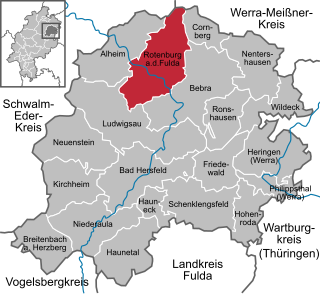
Rotenburg an der Fulda is a town in Hersfeld-Rotenburg district in northeastern Hesse, Germany lying, as the name says, on the river Fulda.

Spangenberg Town in Hesse, Germany

Spangenberg is a small town in northeastern Hesse, Germany.

Antrifttal Municipality in Hesse, Germany

Antrifttal is a community in the Vogelsbergkreis in Hesse, Germany.

Immenhausen Town in Hesse, Germany

Immenhausen is a town in the district of Kassel, in Hesse, Germany. It is located 12 km north of Kassel on the German Timber-Frame Road. The town has 7,098 inhabitants as of July 2020, including the northern village of Mariendorf and eastern village of Holzhausen.

Eppenberg Charterhouse was a charterhouse, or Carthusian monastery, now a ruin, situated on the Eppenberg next to the Heiligenberg in Gensungen, now part of Felsberg in Hesse, Germany. It was established to replace a failing monastery of Premonstratensian canonesses.

West Hesse Depression

The West Hesse Depression is part of the West Hesse Highlands and Lowlands region in the north of the German state of Hesse. Like the East Hesse Depression, it is a series of separate depressions that form a natural corridor and have been an important historical trade route.

Heiligenburg Castle

Heiligenburg Castle is a castle on the hill of Heiligenberg in the district of Schwalm-Eder-Kreis, Hesse, Germany.

Conrad of Dhaun was a German nobleman. His relatives were the Wild- and Rhinegraves of Dhaun. He was Archbishop and Prince-elector of the Bishopric of Mainz from 1419 until his death as Conrad III. His term was marked by the Hussite wars and by serious disputes with the Landgraviate of Hesse and within the city of Mainz.

Altenbrunslar Part of Felsberg in Hesse, Germany

Altenbunslar is a small village in North Hesse, Germany. It is part of the town Felsberg.

Riesenstein (Wolfershausen)

The Riesenstein is a megalith or menhir, which is situated close to the village of Wolfershausen. It is the largest megalith in the district of Schwalm-Eder-Kreis, Hesse, Germany.

Brunslar was a short-lived municipality in North Hessen, in the now-extinct district of Melsungen, Germany. It was created during the changing of district boundaries on 1 February 1971, when the independent communities of Altenbrunslar and Neuenbrunslar fused. On the 31. December 1971 the community of Wolfershausen joined the Brunslar municipality.

Buchenau (Eiterfeld) Ortsteil of Eiterfeld in Hesse, Germany

Buchenau is a district of the market town Eiterfeld in the district of Fulda and has around 350 inhabitants.

The Mainz-Hessian War of 1427 was the final military conflict in the two-century long dispute between the Archdiocese of Mainz and Landgrave of Hesse over supremacy of the Hesse region. The decisive victories of Landgrave Ludwig I over the Mainzian military leader Gottfried von Leiningen near Fritzlar and over Archbishop Konrad von Dhaun near Fulda spelled the end of Mainz's ambitions in the Hesse region. The Peace of Frankfurt, signed on December 8, 1427, decisively ended both the war and the long-standing power struggle between Hesse and Mainz.

References

  1. 1 2 "Historisches Ortslexikon Hessen - Wolfershausen". lagis-hessen.de. LAGIS. Retrieved 13 February 2014.
  2. Statistisches Bundesamt, ed. (1983). Historisches Gemeindeverzeichnis für die Bundesrepublik Deutschland. Namens-, Grenz- und Schlüsselnummernänderungen bei Gemeinden, Kreisen und Regierungsbezirken vom 27.5.1970 bis 31.12.1982[Historical directory of communities in the German Republic.] (in German). Stuttgart and Mainz: W. Kohlhammer. p. 405. ISBN   3-17-003263-1.
  3. Magistrat der Stadt Felsberg, ed. (1986). 700 Jahre Stadt Felsberg: 1286-1986[700 years of the town of Felsberg: 1286-1986] (in German). Stadt Felsberg.