
Brandenberg is a municipality in the Austrian state of Tyrol in the district Kufstein. It consists of the Brandenberg village and the Aschau locality.

These are the 107 municipalities of the canton of Solothurn, Switzerland.

Leinefelde-Worbis is a town in the district of Eichsfeld, in northwestern Thuringia, Germany. The town was formed on March 16, 2004, from the former independent towns Leinefelde and Worbis along with the municipalities of Breitenbach and Wintzingerode. In July 2018 the former municipality of Hundeshagen, and in January 2019 Kallmerode was merged into Leinefelde-Worbis. The population before the amalgamation was 14,387 for Leinefelde, 5,541 for Worbis, 1,021 for Breitenbach and 614 for Wintzingerode. The 10 parts of Leinefelde-Worbis are Leinefelde, Worbis, Breitenbach, Kirchohmfeld, Birkungen, Beuren, Hundeshagen, Kaltohmfeld, Wintzingrode, Kallmerode and Breitenholz.
Breitenbach may refer to:

Sangerhausen is a town in Saxony-Anhalt, central Germany, capital of the district of Mansfeld-Südharz. It is situated southeast of the Harz, approx. 35 kilometres east of Nordhausen, and 50 km (31 mi) west of Halle (Saale). About 26,000 people live in Sangerhausen (2020).

Breitenbach is a municipality in the district of Thierstein in the canton of Solothurn in Switzerland. There are two train stations near Breitenbach, the main being in Laufen and the other in Zwingen. As with most of Switzerland, there are Postauto buses which take people to surrounding cities and to and from the train station. Schweizerdeutsch (Swiss-German) in Breitenbach closely resembles that of Baseldeutsch (Basel-German).

Oberleichtersbach is a municipality in the district of Bad Kissingen in Bavaria in Germany.

Breitenbach am Herzberg is a municipality in southwesternmost Hersfeld-Rotenburg district in eastern Hesse, Germany.
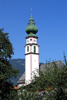
Breitenbach am Inn is a municipality in the Kufstein district in the Austrian state of Tyrol located 5.5 km west of Wörgl and 19 km southwest of Kufstein. The village has five parts and received new parts and house numbers in 2006. It was founded in the middle of the 19th century.

Breitenbach is an Ortsgemeinde – a municipality belonging to a Verbandsgemeinde, a kind of collective municipality – in the Kusel district in Rhineland-Palatinate, Germany. It belongs to the Verbandsgemeinde of Oberes Glantal. Breitenbach is one of the Kusel district's eight biggest municipalities. It is also the Palatinate's westernmost municipality.

Homberg is an Ortsgemeinde – a community belonging to a Verbandsgemeinde – in the Westerwaldkreis in Rhineland-Palatinate, Germany. It belongs to the Verbandsgemeinde of Rennerod, a kind of collective municipality.
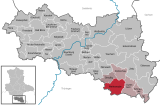
Wetterzeube is a municipality in the Burgenlandkreis district, in Saxony-Anhalt, Germany. On 1 January 2010 it absorbed the former municipalities Breitenbach and Haynsburg.

Breitenbach is a commune in the Bas-Rhin department in Alsace in north-eastern France.

Breitenbach-Haut-Rhin is a commune in the Haut-Rhin department in Grand Est in north-eastern France.

Potůčky is a municipality and village in Karlovy Vary District in the Karlovy Vary Region of the Czech Republic. It has about 400 inhabitants.

Kašava is a municipality and village in Zlín District in the Zlín Region of the Czech Republic. It has about 900 inhabitants.
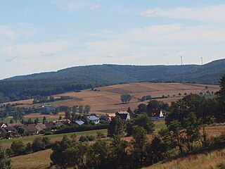
The archaeological site near the village of Breitenbach in Saxony-Anhalt, Germany is an important open-air settlement that dates to the period of initial colonization of Europe by anatomically modern humans. The occupations date to the early Upper Palaeolithic and more specifically belong to the Aurignacian cultural complex. Breitenbach is currently the biggest open-air settlement site in western Eurasia dating to this time period. Overlying the Palaleolithic deposits are the remains of a younger settlement that has been dated to the Neolithic.
Mount Breitenbach, at 12,140 feet (3,700 m) above sea level, is the fifth-highest peak in the U.S. state of Idaho and the fourth-highest in the Lost River Range. The peak is located in Salmon-Challis National Forest in Custer County. It is 2.0 miles (3.2 km) east of Mount Church, its line parent, 1.4 miles (2.3 km) east of Donaldson Peak, 0.85 miles (1.37 km) southeast of No Regret Peak, and 1.8 miles (2.9 km) north of Lost River Peak.
Oberes Glantal is a Verbandsgemeinde in the district of Kusel, in Rhineland-Palatinate, Germany. The seat of the Verbandsgemeinde is in Schönenberg-Kübelberg. It was formed on 1 January 2017 by the merger of the former Verbandsgemeinden Glan-Münchweiler, Schönenberg-Kübelberg and Waldmohr.
The Toter Mann near Friedewald in the Hessian county of Hersfeld-Rotenburg is, at 480.3 m above sea level (NHN), the highest natural hill in the Seulingswald range. This small upland is the southernmost spur of the Fulda-Werra Uplands.


